

19 – 22 October, 2018
The objective of this short excursion north was to round the three Capes (MVD, Reinga and North) in 3 paddle days from Hukatere. The return travel times to the Far North are such a grind that there needed to be some real benefit from making such a short paddle trip.
The prospect of clearing the West coast provided just the incentive.
Splitting the travel days between Friday and Saturday (19 & 20th) presented the option to get half a day paddling AGW.
Sunday (21st) and Monday (22nd) promised good paddle conditions with 1.3m surf conditions, light winds and an ebbing (north flowing) tide through the best part of the day (0800-1400). The plan was to utilise this strong tidal stream with the paddle north from Hukatere, through the Cape Maria van Diemen gap timing our arrival at Cape Reinga at slack tide (1400hrs).
The next day, the same tidal flow would assist with rounding North Cape if the forecast remained favourable. As it turned out I would only get in two paddle days ……..
THIS TRIP: Hukatere to Tapotupotu bay 2 paddle days
Overall Distance 78.9km Time 12.88hrs Speed 6.12km/hr

Saturday, 20 October, 2018 Hukatere
The initial plan was to camp two nights at The Bluff having obtained the necessary permits to access through the forestry roads to this coastal camp. This would be our base while I paddled from Hukatere to The Bluff on Sunday and launched from The Bluff to round Cape Reinga on the Monday; allowing me to paddle light on these days.
However, yesterdays attempt to follow the forest road maps failed as we came to a dead end road 10km into the forest. Being the middle of a Labour weekend and cellphone communications being very scratchy we quickly resorted to plan B. This was to return to Gabby’s at Hukatere to camp for the night and launch the next morning with a loaded kayak for a solo overnight camp at The Bluff.
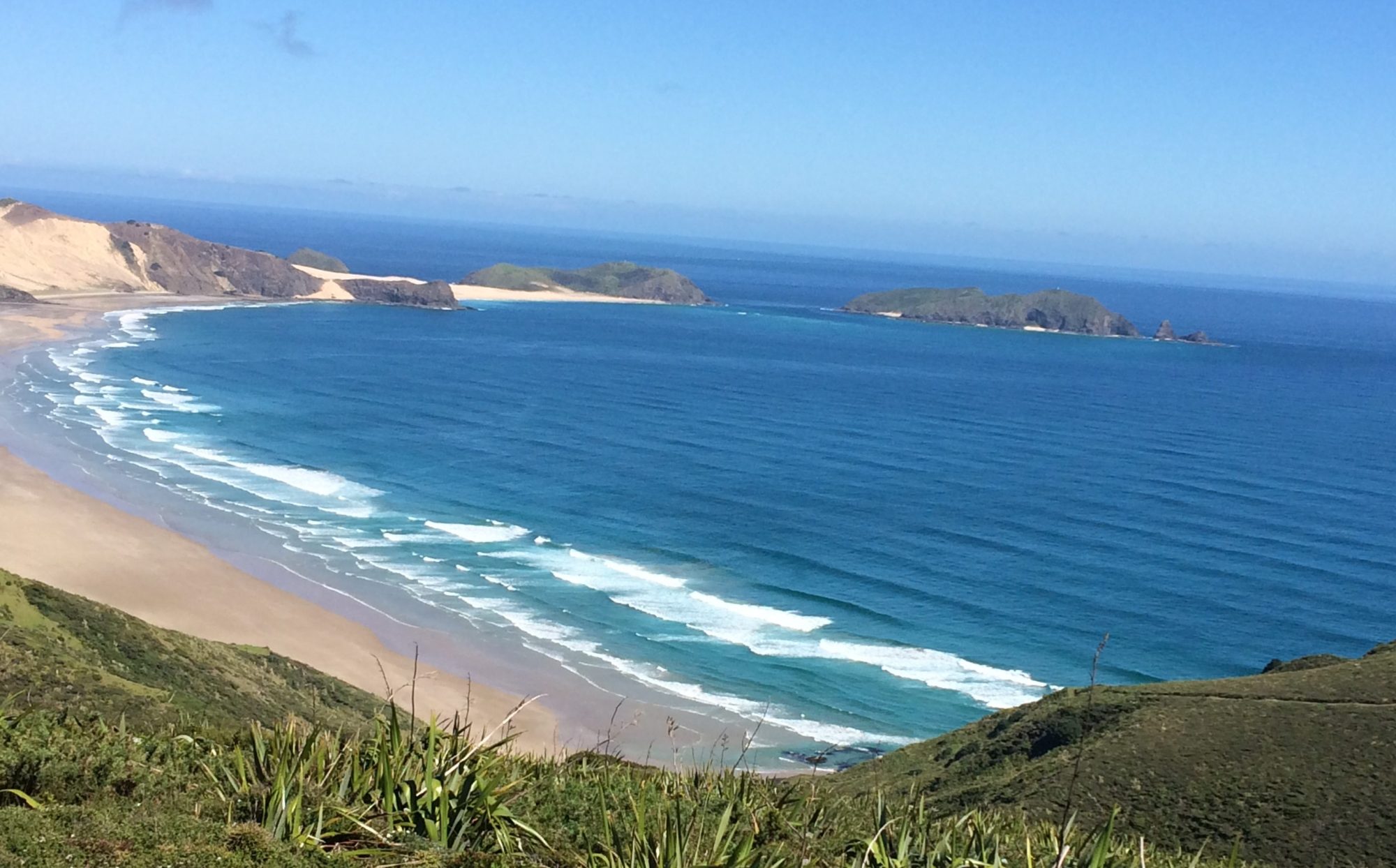
Great to see Gabby again although this time in her campground rather than her BnB. The camp was very quiet (I thought) for a Labor weekend. Took a walk to the beach to check out the Hukatere surf on the evening high tide, which would be the equivalent morning high tide launch time of about 0800hrs. These are always moments of anticipation hoping that the surf is true to forecast; especially after such a long road trip getting here. Thankfully the forecast proved accurate and significantly less menacing than the same surf I landed through nearly 7 months earlier. Although there were still a series of sandbanks creating dumping surf that could still cause carnage if mis-timed; I was relieved to see that there was really little doubt about breaking through that surf in the morning.


Shaz ………… Another 4 hr trip to Pukenui to pick up information about access to Forestry road to get to the Bluff and set up camp for the night. I told Brent last weekend that I wasn’t looking forward to travelling down this road on my own. He said that he would drive there with me and set up camp and then in the morning I would drive him back to Hukatere to launch.
Anyway we picked up the information and followed those instructions. Travelled a long way down this forestry road only for it to come to an end where the forestry guys had been working. Thank god Brent was with me, or I would have freaked out and not being able to tell him where I was.
We turned around and went back to the main road until we found mobile coverage and rang the lady who gave us the information. She apologised as you normally can go that way. So we drove back down to Hukatere and have now set up camp here and Brent will leave here in the morning.
Once Brent leaves in the morning I’ll travel up to Spirits Bay and set up camp there for 2 nights (one on my own and one with Brent). Brent will now paddle and solo camp overnight at the Bluff before paddling round Cape Reinga and joining me at Spirits Bay.
Still not feeling the best, hopefully someone will help me set up camp or it could take me a long time on my own.
Sunday, 21 October, 2018 Hukatere to The Bluff (Te Wakatehaua Island)

Distance 32.5km Time 4.65 hours Speed 7.0km/hr
There was no rush to get on the water today as it was only a 5 hour paddle up 90 mile beach to set up for an assault on the Capes tomorrow.
After a casual cooked breakfast and coffee, Shaz and I decamped and I took Secala to the beach to load up ready for launch. While loading up, a few car loads of surfers drove pass for an early morning surf. A squizz over the sand dunes confirmed that the surf was still relatively easy ………….. but the reality was to be a little different
As usual now, I launched without consideration for timing the sets and paddled out to were there was a channel (hole) between sand banks with the usual idea of holding water until I could gauge the lull between sets for a break out. Well the lull seemed to take forever today. It always seems that way when amoungst it. I was tiring after battling through several solid breaking waves when I heard the nearby surfers whooping at a very large set coming through. Looking out I saw them cresting well above the tumbling waves in front of me and I sensed that a swim might well be on the cards. Similar sights previously have usually been a prelude to carnage.
On this occasion, thanks to a laden kayak, I saw these out with relative ease (for the west coast) despite being driven solidly backwards a couple of times. The down side was the lack of acceleration that you’d normally enjoy when making the inevitable sprint through the lull. Relieved to get out on the 1st attempt and feeling great to be back making progress North again after such a long layoff.
Once safely beyond the surf zone, the familiar pre-paddle routine. Recovering gear from the safety of the day hatch and the VHF check-in with Shaz to confirm everything was OK. I settled into a steady pace North while Shaz made her way to Spirits Bay to meet me in two days. We scheduled our next VHF check-in for between 1230 – 1300hrs tomorrow when I should be outside the Cape Maria van Diemen gap with line of sight to Cape Reinga lighthouse. We knew that cellular contact would be impossible however I was going to be using a newly purchased Garmin Inreach Mini (satellite communicator) for the first time from which Shaz would be able track my progress on the water and communicate by satellite text messaging, as long as she was within cellular coverage to receive them on her cellphone. There was no Coastguard response to my TR call today.
This paddle was a straight shoot up 90 mile beach with an ebb tide assist on a flat calm sea and as low a swell as you can expect on the west coast. My hourly snack breaks and GPS check revealed I was making good progress of about 8km/hr. The snack breaks were a little longer now as I included sending messages to Shaz from the Inreach.
Sharks seemed to be on my mind today after the reported shark attack on a surfer off the Kaipara a couple of days ago.
Paddling was easier with the following current and soon the prominent Bluff quickly became apparent on the horizon.


Landed easily in low surf on the north side of the Bluff that was much more sheltered than the unprotected south side.


It was an hour before low tide and their was quite a few fishermen on and around the rock, all of which had driven up the beach in their 4WD’s from Hukatere in the south or Te Paki in the north.
Plenty going on around the rock with surfcasters all around the rock and families hanging out round the rock pools. Its little wonder there are signs up warning of getting too close to the edge. Tour buses cruised down the beach and a steady stream of hikers who had walked all the way from Twilight beach near Cape MVD.


Great to be back on the water today and making progress. The overall speed average was 7.0km/hr today that included all stops. Happy with that. And happy to heed own advice to ease into the paddling after a long lay-off. Excited now, in anticipation of rounding two Capes after one more sleep and off the west coast for a while.
Finished the day watching my last west coast sunset over a calm sea with a cup of tea. Perfect! I will miss them. Tomorrow it will be champagne at Spirits bay. Can’t wait!

Shaz ……….. Brent up early to have breakfast and take kayak and supplies to Hukatere Beach ready for paddle and overnight camping at the Bluff. Then he came back to help me pack up camp at Hukatere before going back to beach to launch.
Brent only needed the one attempt today thank goodness, it could easily been much different as the were some big dumping waves out there.
Once he made contact and organised himself for the paddle he continued. I went back to Hukatere campsite for a shower and cup of tea. Talked with a lovely Indian family, English couple and a French couple who were staying on to do some work for Gabby. Gabby is not your typical camp ground operator, she is very hands on and full of advice and information about where to go and the history of the area.
The Indian family were travelling a a large motor home. The man I spoke to lives in Auckland with his wife, but they were taking his parents, his brother and his wife who were here on holiday from India.
Around 10am I left for Spirits Bay, stopping at Pukenui for some supplies, then the coffee place around the corner (a container on the side of road shop). All the time watching to see where I had internet. So I can make contact with Brent. People at the Waikere Landing shop said that there isn’t any internet at the Cape or Spirits Bay, I drove back up the road and managed to get one bar, messaged Brent not sure if he got it or not. Messaged Katie to say I would be out of range for a couple of days. That worked as she rang me, so I asked her to message Brent for me.
Got to Spirits Bay at set camp up myself, it took me 1 hour to put the tent up, while the couple sat in their motor home and watched me trying to put the fly on, stubborn tart, didn’t let it beat me! Felt like giving them the fingers.
Nackered now, having a rest now! Go for a walk later.
Monday, 22 October, 2018 Maunganui Bluff to Tapotupotu Bay


Distance 46.4km Time 8.23 hours Speed 5.6km/hr
Up to a perfect day despite a restless night with cough and sore throat. Think I’m getting some of Shaz bugs. Low surf, calm sea. Beautiful dawn. Nothing is going to stop me now after seeing the Cape MVD on the horizon yesterday. On the water at 0700 and an easy clean breakout, and last on the west coast for a while. A misty morning obscured Matapia Island from view for the first half hour. The island is in a direct transit with the Cape so an obvious waypoint. Stopped off the island to enjoy a snack and take some photos. In such calm conditions I contemplated paddling through the hole in the island, but only for a nanosecond. An unnecessary risk, on my own.

Made my way on a calm sea to Scott Point where the tidal stream assisting me north became obvious by the many cray pot buoys in the area. A cray boat cruised by to say gidday.

Approaching Cape MVD a moderate NE headwind kicked in, that would unfortunately set the wind against the tide going through the gap.

Nice moment seeing Reinga through the gap and making first contact with Shaz via VHF after a couple of days. Battened everything down in the day hatch for the run through the gauntlet. Sizing it up, the fast flowing surface was pretty smooth through the gap but some real turbulence on the other side with wind against tide in obvious shoaling areas. Seeing the huge standing waves through the gap was pretty daunting; however the beach end of the turbulence looked more manageable, so quickly cut across to the south end of the gap.


Was slingshot through the gap reaching 13.2km/hr (according to GPS). All my focus now was negotiating the worst of the shoaling and turbulence. This was literally “riding the seat of your pants” territory. Happy to pick a good line and get through, not without my heart in my mouth a couple of times as breaking waves one moment in front of me, the next moment chasing me from behind.
Breaking clear, I settled into a steady paddling rhythm into a sloppy chop caused by a 13+kt NE headwind against the current. Despite this, I start to sense that a major milestone for this adventure is now all but done.

Progress is slow now and I get a hurry up from Shaz to “turn the turbos on”.

Gradually getting closer to Reinga, I could make out individual people at the lighthouse lookout.


Mentioned to Shaz earlier that I would try to land at the beach directly under the Cape and come up to see her but decided it was too rough at that beach today.

Reaching the Cape, the wind died away however it had slowed me down sufficiently that the tide had now turned against me. The paddling became tough. As soon as you stopped paddling you could see yourself losing ground against nearby rocks. Called Shaz on the VHF to say I’d be pulling in to Tapotupotu Bay as I don’t think I’d make it to Spirits Bay today at my current rate.


Very glad to pull in to the beach and begin to enjoy the days achievement. Champagne with tea today.
Sure enough, I was coming down with a “man flu” and wasn’t too flash the next day. The 3rd Cape would wait for another day. A super sense of achievement having now cleared one of the major obstacles on the entire coast and the demarkation of the West coast. Will hopefully start making some real progress round the North Island unencumbered by the West coast sea and surf conditions.