

6th March – 25 September, 2020

THIS TRIP: Pukerua Bay – New Plymouth 9 paddle days
Overall Distance: 332.8km Time: 57.9hrs Ave Speed: 5.7km/hr
6 – 9 March
A long (Taranaki Anniversary) weekend to play with this time. Four full days available to get as far up the home straight as possible. Luckily the weather permitted 3 consecutive days on the water. Not bad for the west coast.
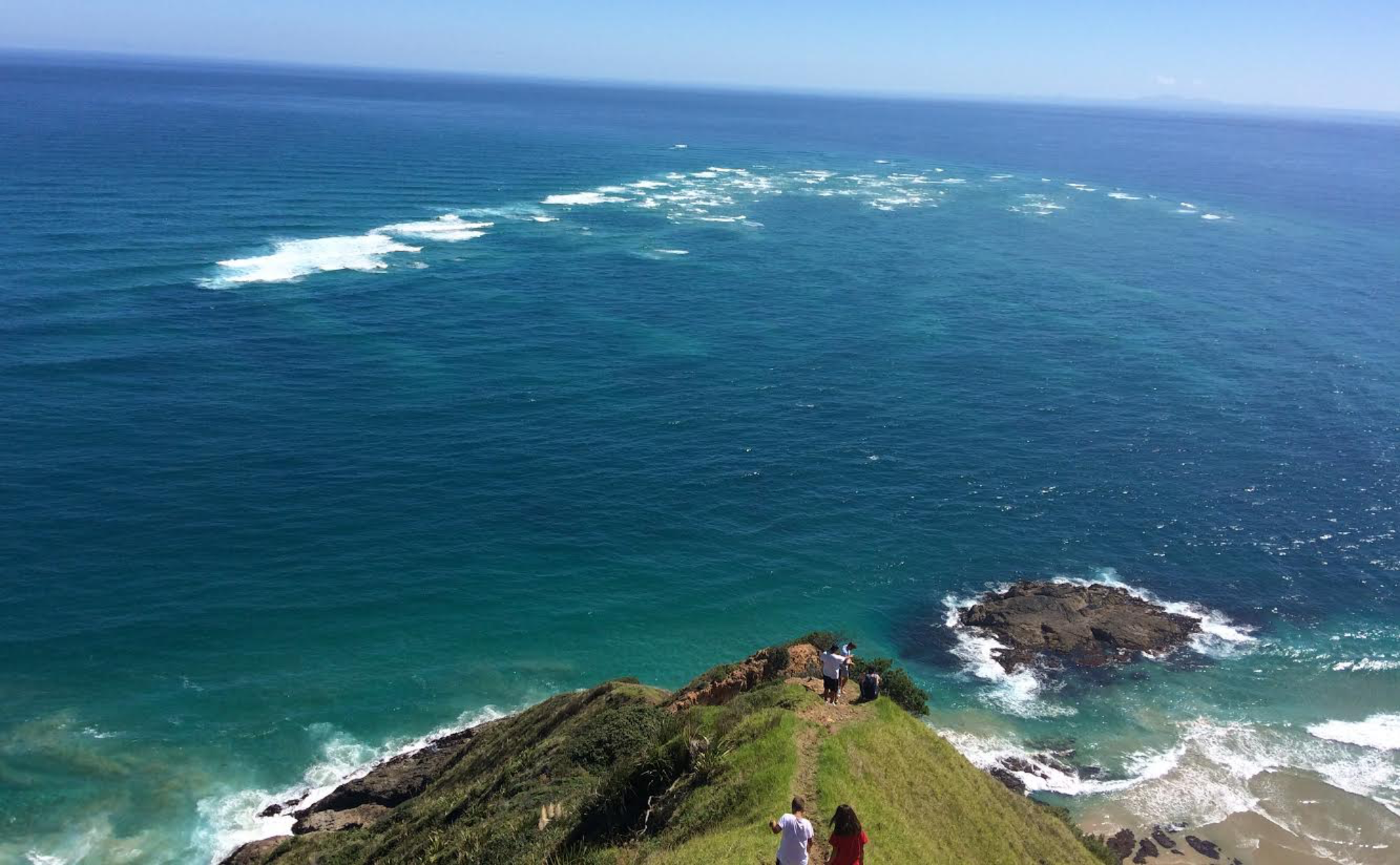
6 March, 2020 Pukerua Bay to Waikawa Beach

Arrived at Pukerua Bay just after sunrise, after a short drive from our overnight stay at Manakau. Eased into a calm Pukerua Bay.

Followed within 100 meters of the shoreline and State Highway 1, filling now with commuter traffic. Saw Shaz drive by in the camper and stop at one of the lay-bys for some photos as I rock hopped around her.

Caught up with Shaz again, 2.5 hours into the paddle, parked up at Raumati Beach. Came ashore for a few moments and confirmed the plan to meet at Otaki for lunch.
Sea remained flat through the Rauoterangi Channel inside Kapiti Island although the ebb flow was working against me.

Once out of the lee of Kapiti Island a reasonable swell was exposed, with occasional big sets, that kept my attention seaward as I cruised very close to the beach. After 6.8 hours from Pukerua Bay, Shaz guided me into Otaki Beach for a late lunch.

In these conditions, I decided to put in another hour to Waikawa. Didn’t worry that we hadn’t scoped out Waikawa beach for access from the sea; or the shore. Enjoyed the prospect of coming in somewhere different, so off we went to carve off one more hour, and deal with the exit when we got there.

The landing was all too easy with Shaz there to guide me in. The Waikawa Stream was too shallow (low tide) to paddle, so with Shaz’s assistance we pulled Secala a few hundred meters up the beach, thankfully on hard sand.

Shaz ……… Friday 6 March 2020
Left home around 4.30pm last night and headed for Pukerua Bay! We stopped at Gary & Phillippa Betts (POP) on South Manakau Road, before Otaki. Arriving around 8.40pm, cooked up baked beans on toast and a cup of tea. There was a knock at the door, Gary and Phillippa came and introduced themselves and welcomed us. Up early, left the Betts place 6.20am! It’s a 37 minute drive to Pukerua Bay, so not to far and Brent can get started for the day.

Brent was set up by 7.41am and on the water by 7.48am, heading for Otaki for lunch!

I watched him leave then headed along the road stopping in one of the lay-by’s along the coast road before Paekakariki.


Took some photos and then drove to Raumati Beach! What a beautiful spot, lots of people walking along the beach.


When I arrived there were 3 motorhomes parked up which is the maximum for staying overnight here in the car park. Went for a short walk along the beach heading south as I didn’t want to get my feet wet going north. Then spoke to the lady from the council taking motor home rego numbers that had stayed the night! She thought we had stayed also as I was parked in a non-compliant area. I said no that I had just arrived from Pukerua Bay as my husband is kayaking from there to here! Wow, she said once I explained what he was doing, and she said ‘that had better not be what her husband brought a 2 man kayak for!! ‘. Not happening, no way!!. We had a good laugh anyway. I asked where to go and get a good coffee from, she suggest the ‘Green & White Ribbon cafe just on the other side of the park. Before going, I looked down the coast to see if I could see Brent and there he was way in the distance. Plenty of time for a walk and a coffee.

Gosh, people are already swimming in the sea and another man has put out his Contiki for some fish. Brent much closer now, and he made contact.

As he got closer he came ashore for a quick chat around 10.22am and then he was off again at 10.29am, saying he would see me at Otaki in 3 hours.


While I was waiting for Brent to arrive at Otaki, I got my camera out and took a few photos. Hopefully I’m improving my skills!


Brent arrived at Otaki around 2.55pm, it took longer than he thought as the wind changed against him.


I had made him a late lunch and coffee while he decided if he would go on today or call it quits for the day.
Brent decided to continue onto Waikawa beach just under an hours paddle further along the beach. So I drove on towards Waikawa to check out the best spot to land on the beach. When I got there I quickly realised that the waters edge was a long from the van. I wasn’t game enough to drive down onto the beach like some cars did! Brent called on the VHF and asked where to come in!

I walked down to the waters edge to meet him and got some photos, and looking back at Waikawa.


Once we got back to the van, we loaded up all the gear plus the kayak and headed back to Gary & Phillippa Betts POP for the night.
7 March, 2020 Waikawa Beach to Scott’s Ferry

Stayed at the same campervan Park over Property (POP) just down the road at Manakau again tonight. As we drove out of Waikawa Beach yesterday I noticed a boat ramp on the stream beside a footbridge. Thought I would try paddling down the stream as the tide would be further in this morning. Expected though to have to get out a drag Secala over the shallows as we reached the beach.


Once clear of the bar, set off towards Waitarere 3 hours up the coast. The forecast Northerly 10kt slowed me down, adding half an hour to this section.
Approaching the Manawatu River bar I could see a couple of jet skis playing in the good sized line of breakers extending offshore. After watching them for a while, I could figure out the outer extent of the river bar and safely cruise outside it and through some muddy turbulent water to Foxton Beach about 3km north of the river.

After lunch, departed Foxton through low surf and was greeted by 3 women having a swim; one of whom speculated “Are you paddling around NZ?” When I replied that I was, they burst into cheers and clapping. Funny wee moment.
Aiming for Scott’s Ferry 3 hours further up the coast. This is another “wing it” scenario, not having checked out the beach access situation in advance.
Typical afternoon west coast conditions developed with winds increasing as they backed from the north through west to the south west.
The continuous beach from Foxton is backed by exotic forest, behind the sand dunes. This is a busy stretch of beach with many vehicles , motorcycles, bikes all the way towards Tangimoana. With speed signs on the beach and a 4×4 police ute patrolling this “highway”. Many were involved in fishing of one sort or another; surf casting, contiki long lines and nets.

Arrived off Tangimoana taking a wide route around the Rangitikei River mouth to avoid the worst of the turbulence over the river bar.
North of the river and heading back towards the beach, it became apparent that contact with Shaz would be difficult. Failing to make contact by VHF after several attempts, I reached for the cellphone that displayed “No Service”. Hadn’t anticipated no cellphone coverage on this coast! Came ashore on a wide beach at low tide; to see if I could get cell reception by climbing to the top of the sand dunes. There was one bar reception, but very sketchy, not being able to connect, but seemingly able to leave a voicemail message. Said that I would paddle up the Rangitikei River until we managed to connect by road or by phone. Figured that I would find a house or some better reception as I got closer to civilisation. The inReach satellite tracker was on and would be very useful today so long as Shaz was within cell reception. This would give her regular updates of my position.

Hoping that my phone message would be received, I dragged Secala up the beach, over the dunes and across the river mud flats to the river.


Relieved that the mud wasn’t too soft which would have made a messy portage. Paddled about 2km up the river until I saw a small boat ramp on the north (left) bank. Intended on exiting here, as there were houses nearby; when I saw some people fishing, a little further up the river on the south bank. Headed over and landed a respectful distance away so I didn’t upset their fishing.

Explained to them that I was looking for my wife who was driving a camper van. They said that they had seen a camper just down the road in Tangimoana and offered to go and find her. No sooner had they left the river, they were back with Shaz right behind them. Shaz had located me via my inReach tracker and found her own way along a narrow overgrown gravel track, down a shingle bank and onto the exposed river bed. Our compact campervan demonstrating its versatility despite a rear mudflap working loose along the way.
There was some concern expressed by our 4WD friends, that we would not make it back up the shingle riverbank on our way out. They kindly offered to stick around and tow us out if necessary. As it turned out, our camper easily made it out and off we went to look for the Tangimoana campground.

Shaz …….. Saturday 7 March 2020
Up a little later this morning as not so far to travel to launching spot at Waikawa beach. Unloaded and ready to launch on the river at 8.08am.


Brent was going to paddle as far down the river as he could and the drag the kayak to the edge of the sea.

I drove around to where I parked closer to the beach yesterday . From there I could see him pulling the kayak along the river towards the sea. He called on the VHF to say he was set to go and see me in Foxton unless I decide to stop in at Waitarere beach.

Driving towards Foxton I did decide to go down and have a look at Waitarere beach, glad I did its a very nice beach.

Once I got there I realised that I hadn’t had any breakfast so decided to have some at a little cafe there.

Great bacon and eggs with coffee at a really good price the place is called ‘@ Beach Cafe right next to the 4 Square and a little gift shop!

Finished my coffee and set off for Foxton beach!
Got a good spot in the car park close to the walkway down to the beach and not many people here. However it didn’t take long to start filling up and then the lifeguards arrived and set up with a safe swimming zone.


The beach is a road with a 30km speed limit, however the lifeguards put up a cones and road closed signs at each ends of the swimming zone to ensure that the public are safe!
I made Brent some lunch and coffee ready for when he arrived, putting the coffee in the thermos. He arrived around 1.50pm. Had a quick lunch and then launched again heading for Scott’s Ferry.
So I set off for Scott’s Ferry driving on State highway 1 to Bulls and then out towards the coast from there. It’s around a 50 minute drive from Foxton. However along the way I decide to stop at Waireka Honey Centre and brought a Real Fruit Yoghurt ice cream, they are so good from here!
I turned off at Bulls for Scott’s Ferry where Brent wants to come in, I was almost there when I saw on the road side a Historical site and pulled over. It was the old Scott’s Ferry and a write up about it.


I arrived and saw the Camp ground on the left driving through the settlement on my way to the beach! I need to check out the best spot for Brent to land along the beach. Once I arrived at the car park I soon realised that the beach was a lot further away than we thought! I parked up and walked to the beach, around a 15 minute walk and not really suitable for pulling/dragging a kayak back to the van. Reception not the best, only one bar on the beach, so I tried to ring Brent but NO answer. Left a message and texted him. I took a video of walk back to show him what it was like. Once I got back to the camper I decided to head back to Bulls (25 minutes) to get better reception and call again/leave a message. I told him that I was going back to Tangimoana on the other side of the river hoping that there would be better access! Decided to fill up with diesel while in Bulls and then headed back down the road towards Tangimoana (20 minutes). Once I got there the access to the beach wasn’t much better, and hardly any reception here for the cellphone either. Driving towards the beach it soon became apparent that the road just stopped from erosion and I couldn’t really turn around. So I parked and walked down to the beach where I managed to get 2 bars on my phone and rang Brent, no answer so I left another message. I had to back down the road to a place where I could turn around, thank goodness there was no traffic coming down the road! I drove back down the road to the local shop and asked them if there was anywhere I could get internet as I needed to check iReach to see where about Brent was. He must be getting close now. They said the best place was outside the shop, I see that I’ve missed two phone calls from Brent so tried to ring back without any luck! Driving around trying to find somewhere that he could land, the lady in the shop said that the Tangimoana boat ramp would be the best place.

So I drove down there and got 2 bars on the cellphone, so tried again and then saw a message from Brent and listened to it. He has landed somewhere but couldn’t see me and wanted to know where I was! He sounded a little bit grumpy, but then so was I! Finally I got an update on the iReach and could see that he was up the Rangitikei river. So I looked on my GPS and there was a road called the Old Scott Ferry Road and it looked like he was heading towards that. Hope he stops around there otherwise I will miss him and not sure what to do then! So I set off towards Old Scott Ferry Road, as I head down it I thought OMG no where to move if someone else comes my way. Then I came to a point where the road went down towards the river, so I pulled over as I didn’t want to get suck in the sand. Just as I was getting out of the camper van a Ute came up from down the beach and stopped and asked “ are you Shaza”, I said ‘yes I am’. Brent was on the river bank and they had come to look for me! They said it was safe enough for me to drive along the river bank as it was pebbles and very firm. So I drove down onto the rivers edge and there was Brent standing talking to some people, so headed straight for him! All the while feeling happy to see him and frustrated at the same time, as I’m sure he was too!


It was now 6.30pm! Thank god there was a camp ground here in Tangimoana, so we headed straight for that!
Upon arriving the office isn’t manned and you have to fill in details in the book and put the money for the night into the honesty box. Couldn’t find any kitchen, but there are toilets and showers thank goodness! I had a shower before I cooked tea, Brent was going to have his later on! After dinner Brent went for his shower, but he came back and said ‘what’s the code for the lock on the door’, I asked “what lock on the door, I just went straight in!” The men’s block had a lock on the door. Suggested he to go and check in the office where there were instructions for stuff. He never came back so I guess he got in! WRONG, he couldn’t; so just used the women’s shower. OK!! Funny, luckily there wasn’t really anyone else there!
8 March, 2020 Tangimoana to Whanganui

Up for early breakfast today preparing and hoping to get most of the day. Has to be all the way to Whanganui today, about a 9 hour paddle, as there are no real access to the beach through the coastal Santoft Forest. I have had no weather forecast since yesterday morning due to poor internet in the Tangimoana area.
Headed down to Tangimoana boat ramp; where yesterday, Shaz discovered a spot with reasonable internet coverage. The weather forecast is good for the day so the target is Whanganui.
It’s an hour before HW and the ramp is busy with boats wanting to get over the river bar.

No coffee break with Shaz today and I didn’t bring my coffee kit on this trip!! Lesson learnt! Won’t leave it at home again.
It turns out that from the boat ramp I can see where I had dragged Secala over the dunes to the river yesterday. Would have been easier had we known about this ramp. Never mind …….winging it adds to the adventure!


Took my cue down the river following the lines of a fishing boat out through the bar. There was still a good incoming tidal current at the river entrance but once in the clear, the sea was flat.


A nice moment to see Mt Taranaki clearly directly ahead as I cleared the bar and set a northerly course. Felt now that this part of the NZ adventure was quickly coming to an end. Mt Taranaki would stay visible on the bow all day.
In the conditions I could stay within 30m of shore most of the way. Skirted out a little wider, at times, to avoid surf casters lines. Only the occasional vehicle on this more remote section of coastline.

Just over two hours paddle from Tangimoana I past the prominent fire lookout structure overlooking the Santoft forest. Thought for a moment whether I could go to climb the lookout, but figured, these days, there will be good security measures in place. About an hours paddle down the beach, the chart showed the location of the wreck of the Fusilier (1884). Brought back memories of the wrecks on the beach at Kaipara. Kept very close to the beach to try and find any signs of it, unfortunately I didn’t see anything although could have easily missed it amongst the driftwood along this section.

Found a quiet stretch of beach a little while later and stopped for lunch. About half way to Whanganui now.
The easy paddling continued through the afternoon distracted only by the turbulence at the Turakina and Whangaehu river mouths. The inshore currents easily detected by the discoloured river water; especially the Whangaehu that was very brown.

A little further down the beach I got waved down by a fisherman (Luke) on the beach who reckoned he had lost contact with his contiki while pulling it back in. I offered to go and check it out. Seemed fine to me, and escorted it towards the shore for a while. As I gave Luke a thumbs up and peeled off to continue northward, Luke held up a fish. You beaut ……… darted ashore to claim a nice little pannie snapper.

Could make out the Whanganui river breakwaters now and watched several boats, from a distance, enter the river over the bar. It appeared pretty flat but couldn’t be sure from a couple of miles away. Low tide now as I nudged up close to the breakwater and gingerly entered the river mouth.

Despite a gentle flow seaward, the entrance was smooth.


Crossed the Wanganui river mouth easily and onto Castlecliff beach. Castlecliff pretty much marks the end of an uninterrupted lowland beach all the way from Paekakariki. The rugged Taranaki coast awaits!


Shaz ……. Sunday 8 March 2020
After spending the night at Tangimoana campground we set off to the boat ramp to launch rather than go back to where Brent came in on the Rangitikei River. All sorted by 8.01am to launch from the Rangitikei river boat ramp and followed out some fishing boats.


OMG, the boat ramp is so busy this morning everyone making the most of the great weather. Not sure how they get on coming back over the bar when they want to come back in! Guess they wait for high tide, that must be why one boat came back in when they realised they forgot their cigarettes! They said they can’t do without them all day, SAD!!
After packing up I headed for Castlecliff, Whanganui stopping at Mother Goose cafe in Bulls for a coffee and some breakfast. From here I headed for Whanganui and stopping at supermarket on the way. I still had so much time to kill before Brent would arrive at Castlecliff beach I decided to go and visit my friend Deborah’s mum who lives in East Whanganui. It was great catching up with her and seeing her new home that she had only moved into recently after spending 23 years in her other place. So good to see that she is still very independent getting out and about when she wants too! Even though she has Home Help coming in to help out with her domestic chores, she is still driving herself around at 84 years old. After leaving her place I went straight to Castlecliff beach to check it out. Once I got there, there was plenty happening! Lots of people on the beach and swimming, local market was on and the cafe and gallery were busy with tourists and locals.

I parked up and checked out the market and then went for a coffee at Citadel cafe for a coffee. Very nice it was too!
After my coffee I went and parked up in the car park that looked down over the surf club and down to the Whanganui river mouth, awesome views from up there!

Brent came into view around 5pm, made contact but reception wasn’t the best on VHF. I told him that I was going to drive down to the car park beside the surf club.


So around 5.15pm he landed on the beach.


What was great was a fisherman gave him a snapper for our dinner tonight, yum!

Tonight we are going to stay at the Springvale car park and then most likely go home tomorrow!
21 March, 2020 Whanganui to Waiinu Beach

Drove down to Castlecliff Beach at daybreak from our now familiar overnight freedom camping park up at Springvale Park. The squatters in their tent weren’t there this time.
A couple of hours from high tide and although the dumping surf was low, it looked like a wet west coast welcome on this exit.

The forecast promised increasing NW head winds backing West as the day progressed. Our plan was to see how far we could get today with exit opportunities at regular intervals. Firstly Kai Iwi Beach (1.5 hr), then Waiinu Beach a further 2.3hr; and if really lucky, Waipipi Beach a further 2 hours.
Sure enough, after a cool down getting through the shore break, I set off in a NW direction towards Kai Iwi Beach in a light offshore breeze. The topography changes here, from a sandy beach backed by dunes and lowlands; to limestone cliffs shrouding a narrow black sand beach. Beach access is much more intermittent from here onwards.

Soon enough I was at Kai Iwi Beach where I saw our camper van parked on the waterfront. Gave Shaz a call on the VHF and said I would push on to Waiinu Beach despite the NW making itself known with occasional gusts. As the NW chop increased; I hugged the shore until Ototoka Beach hoping to get some lee behind the Waiinu bulge in the shoreline. I could clearly identify Waiinu Beach in the distance with its prominent line of pine trees and a couple of conspicuous white houses.
Approaching Waiinu Beach, I couldn’t reach Shaz on the VHF despite several attempts, going backwards each time, in the now blustery conditions. Unlike previous landings, we had actually recently done a reccie to this beach so I knew where the best shore access points were. I landed easily in the low surf at mid tide.

Shaz arrives at Waiinu Beach campground just moments after I land. We got our ETA timings a little mixed up.


As the forecast conditions have set in, it looks like a lazy afternoon for us at Waiinu Beach. It’s a little gem of a spot, so happy to hang out here for the rest of the day.

Shaz ……… Saturday 21 March 2020
We spent the night at Springvale car park in Whanganui. Up early around 6.15am in the dark, have a coffee and then head for Castlecliff beach to check out the conditions. Arrive about 6.50am, everything looks good at the moment so its all go! The wind is supposed to get up today, so even if Brent makes it to Kai Iwi that’s another 1.5 hours off the next trip.

Brent all sorted and launched at 7.32am.


You got to love the west coast, it gave him a quick reminder of how different the conditions are on this side of the island. He got soaked getting out, but he made it on his first attempt so that’s good! Took a video of his launch and sent to family and friends!


I set off for Kai Iwi beach, stopping at Funky Duck for takeaway coffee. The man there said ‘You are up and about early this morning’, I said yeah, husband is kayaking around the North Island and he just launched from Castlecliff beach heading for Kai Iwi maybe further! He was impressed, and said ‘Well he won’t get Coronavirus out there!’ He said that he had already been to the supermarket on his way to open the cafe. The place was packed already at 7.30am and people filling up their trolleys, bloody crazy!! Anyway got my coffee and set off for the short drive to Kai Iwi beach.


Once I got there I had a walk around and got some photos and replied to messages that I had got. Today is our daughter-in-laws birthday in Auckland, hopefully their plans for today go well. Unfortunately with the Covid-19 virus going around you just don’t know; things are changing daily. It nice that her sister is here from France to celebrate with her.
At 9.07am Brent comes into view and says that he is going to continue onto Waiinu Beach.

He wasn’t sure about the cellphone coverage between here and there so keep an eye on the iReach tracker as he may have to turn back!
I left Kai Iwi and headed for Waiinu beach turning off at Waitotora, just a 30 minute drive plenty of time. Before turning off I checked where Brent was on the tracker. He’s almost there. Didn’t think he would get there until around 12.30pm.
As I was driving through the campground gate way I saw that he was already on the beach, oops!!


Brent isn’t going to continue today as he was battling a head wind to here! We have decided to stay the night here and go home tomorrow.


It’s $10 per night here, no facilities but a really nice quiet place to spend the night. However we can only muster up $9.40 in coins, hopefully that will be OK!
After dinner we sat outside and enjoyed a wine, while the sun went down!


So four months later, after Covid lockdown and Shaz breaking her ankle, we resume this North Island adventure. Have avoided winter paddling, so far; preferring the longer warmer days. With only a few paddle days remaining to complete this circumnavigation, there is a bit of anticipation in doing so now; winter or not.
01 August, 2020 Waiinu Beach to Patea
Expecting to have lost much of my paddle fitness since March, I planned to break the next few paddle days down to around 4 – 6 hours to be safe. This meant that Patea came into the frame as the next landing, about 4.5 hours paddle away. Patea has a narly reputation as a difficult river bar and shore break. The couple of reccies that we had done there recently definitely confirmed this.

On the way through to Waiinu Beach yesterday afternoon we stopped at Patea for a look at conditions. The tide was at half flood with only a W 1.0 meter swell forecast. Never seen the river bar and beach so flat. Conflicting with this were some notes that I had made on recent reccies. “Swell W 1.1m (Swellmap); NW 0.8m (PredictWind) My observation at HW is that this is too dangerous. Dumping very heavily on the beach. River entrance too treacherous.”
The swell was forecast to increase significantly to W 1.8m overnight though, so there was no telling what I’d face when I got there. Launching at first light tomorrow would get me to Patea at about 1130hrs when there would hopefully be enough of the half ebbing tide remaining to safely cross the bar. The alternate option was to land on the beach just north of the river.


On arrival at Waiinu Beach I organised and dragged Secala to the beach ready for an early start. There was only one other person at the campground that night.
We both had restless sleeps in the camper last night. Eventually got up at 0500 for muesli and coffee before heading down to the beach by headlamp, to wait for first light and size up the shore break at nearly high tide. There was a little nervousness during the launch as it felt such a long time since my last west coast launch.
At first light, an hour or so before high water, I launched into a low dumping surf. Always good to get a dry start to the day. Made good time to Waipipi staying just outside the surf zone. The forecast light offshore (NE) breeze offered easy paddling.

The planned VHF checkpoint with Shaz at Waipipi didn’t quite eventuate with Shaz running a little late. She arrived soon after to check in. I confirmed that I was good to continue to Patea.
The next landmark was the wind farm being established north of Waipipi. It seemed to take forever to leave the wind farm behind. A GPS check showed that I was barely doing 5km/hr. Whether it was my fitness or the tide, I’m not sure. I picked up the stroke rate.
This stretch of coastline from Waiinu is a mixture of rolling sand dunes and cliffs offering sanctuary if necessary. From the wind farm, the moles of the Patea river mouth were visible.

Shaz contacted me by VHF from the car park above the Patea river mouth about a half hour before arriving. Shaz said the surf wasn’t too bad with occasional breaking surf as the sets rolled in. When I arrived I decided to give the entrance a miss as it looked like the tide had ebbed sufficiently to create a turbulent undertow at the entrance. Decided on a beach landing on the north side where the surfers were enjoying some ideal conditions. Watched the surf conditions for a while, and even though the bigger sets looked narly, there was a good period between them. I also observed a gap in the shore break that I could possibly exploit. After letting the next set roll under me and dump heavily on the shore, I managed to time my run perfectly to the beach for a dry run.


Built in England in 1889, the Waitangi, originally named the Banks Peninsular, was 120 feet (36.58 metres) long, weighed 171 tonnes and had a top speed of 12 knots. She had been renamed the Waitangi by the time the Pātea Co-operative Freezing Company bought her in 1919. The steamer had refrigeration installed and was used to take meat out of the port and carry supplies for the company store on her return journeys. She foundered here with a cargo of coal.


Relaxing afternoon spent here watching surfers enjoying the conditions. And a quiet contentment to be back on the journey; to get through the paddle day “unscathed” and in better shape than expected.
Shaz ……….Friday 31 July 2020
On the road again to Waiinui so Brent can continue his kayak adventure!
Well neither of us got much sleep last night, not sure why it is so quiet here!
Anyway brent was up at 5am, got his breakfast, coffee and then got ready to start his paddle to Patea. He called me once he was on the water and ready to leave at 6.50am. It is about a 4 – 5 hour paddle to there! I headed off for Waipipi beach at Waverley around 8am, to see if I could see him around the half way point of his paddle. As I was running a little late there was no time for a coffee at Waverley, I’ll go there on the way back from the beach.
When I got to the beach, I drove down past the boat ramp drive way to where we had lunch one other day. No reception to see where he was on the iReach, tried the VHF and couldn’t reach him! Oops, maybe I’ve missed him! I drove back to the grass area above the boat ramp and could see him along the coast a little, so contacted him on the VHF! He said that he was going well and would see me at the Patea river mouth in a couple of hours.
I headed back towards Waverley and went for a coffee at ‘Main Street Cafe’! They do a great coffee, food and very friendly in a great atmosphere! Lots of little signs with different sayings on them, loved this one, most people can relate to this!

A couple of locals there getting their coffee and hot chocolates on their way to ‘Ripper Rugby’ for the kids! All dressed for the conditions, Hunting and fishing tops and red band gum boots!! Went across the road to the 4 Square for small bread rolls to have with our soup for lunch.
Driving towards Patea, you get a good view of the new Wind Farm being built – very impressive.
Great views of Mt Taranaki, to my right with plenty of snow!
Not far until we get home to New Plymouth now, and complete the North Island part of Brent’s epic journey!
Driving past Patea Area School and saw this great message at there gate! ‘Tomorrow belongs to those who prepare for it’, so true! Along the bottom of board it said ‘Growing good people for a changing World’.

I arrived at the Patea river mouth look out around 10.30am, great views of the river mouth and assess the conditions for Brent. About 11.15am I saw Brent in the distance and contacted him on the VHF, he said he would contact me again once he was a bit closer. Once he made contact with me I told him what it was like and suggested that I go down to the car park near the river mouth and assess the situation from there! The swells were up and down, some crashing right at the entrance and others further down the river. He decided to come in onto the beach on the north side of the river. I couldn’t see him from where I was, and with ankle still not strong enough to cope with sloping sand hills waited for him at the car park.
Managed to get some photos of the river mouth and the wind farm across the river in the distance. After we had some lunch with drove around the corner to the freedom camping area to set up for the night.


OMG, some old friends/work colleagues Bryan & Shelley just pulled up in their camper van for the night. Nice to catch up with them.
02 August, 2020 Patea to Ohawe

No rush to get on the water today. Waiting for the high tide at 0900 hoping that there would be enough water over the bar to paddle out the river entrance. Forecast swell was for 1.7 meters today, similar to yesterday.
An early look at the river mouth, an hour before HW, wasn’t encouraging. The larger waves of the sets were still breaking heavily at the entrance. I had to size up my 200 meter sprint between sets. Timing was key …… as usual. There was a fair degree of apprehension as I launched at the boat ramp up the river. Shaz was heading for the wooden jetty near the surf club for a photo opportunity.
I paddled down the river to the jetty where Shaz was waiting with her camera; before heading downstream to size up the entrance again.

Observed a couple of sets roll through and break at the entrance. I watched the next set dissipate and committed. At sprint speed I headed out with the horizon looking flat. Then in the space of a few seconds two waves reared up at the entrance ahead. I hesitated momentarily trying to judge their life cycle; then committed. The only real option.
Hammer down I rode up the face of the first wave, stalling as I slapped over the crest. The larger 2nd wave was looming as I tried to regather speed. Seeds of doubt grew as I climbed through the face to near vertical, before cresting, hanging in mid-air, leaning forward and slumping down the other side. The coast now clear for the sprint over the bar.
At a safe distance off shore I let the adrenaline dissipate before giving the usual paddle wave to Shaz. Relieved to be clear of this major obstacle; I put Patea behind me.

This coastline is a solid line of imposing cliffs, save for small beach heads at the mouth of the Tangahoe and Manawapou Rivers. About half way to Ohawe (3 hours) the Manawapou River mouth offers vehicle access and an escape route is necessary. Shaz and I had recently done a reccie down Manawapou Rd to confirm that access was still available. The only other escape route through the cliffs is at Waihi Beach, Hawera about 5km from Ohawe.
Eventually the Ohawe surf club building appeared, conspicuously white against the farmland backdrop. Shaz made VHF contact reporting that a low tide rocky landing awaited.

On arrival Shaz advised that staying close to the northern rock wall offered a better sandy area to land. Ended up surfing in on a small wave over the rocks.

Bloody good to be back into it after a 4 month hiatus; with anticipation high now of finally completing the North Island.
Shaz ………. Sunday, 2nd August
Good nights sleep thank goodness, was a little worried as some strange guy in a BMW sports car kept hanging around close to single female travelling on her own. She was travelling on a bike with all her gear, I’m sure she was fine and would know how to look after herself! However the parent in both of us made us a little suspicious, so kept an eye on her! He left around 9.30pm thank goodness!
Brent went for a walk down to the beach at around 7am to check out the beach and came back saying that that guy was sitting on the beach with a fire going. Looks like he’d been there all night! Weird!!
Got to sleep in a little this morning, as Brent was having a later start today! He is heading for Ohawe today just north of Hawera. I managed to get some video of him getting out of the river, only wish I could have managed to walk on the sand dunes and gone over to the river wall too get better footage. However Bryan was over there and looked like he was videoing it, so here’s hoping that I can get a copy of that.
OMG, that weird guy has turned up in his car again (9.15am) and parked right near her camp and just sitting in his car.
I left Patea about 11.15am and headed for Ohawe where I will meet up with Brent before heading home!
Decided to stop in Hawera for a coffee before going to Ohawe. Amazing views of the Mt Taranaki today, completely different view from this side to New Plymouth side! Stopped at the turn off to Ohawe beach and took a photo of the mountain.

Parked up at Ohawe beach with an awesome view back down the coast towards Patea. Have a long wait before Brent is due here, so heated up some soup for my lunch and then watch a movie on my iPad Pro.
Around 2.30pm I saw Brent in the distance, so got the coffee ready to put on when he gets closer. He came ashore at 2.55pm onto a rock shoreline.

As I can’t go down to the beach with my ankle, I put the coffee on and soup for his late lunch.

By the time we packed up and headed for home it was after 4.15pm, but a good day’s paddle for Brent.
15 August, 2020 Ohawe to Opunake

The 2nd wave of Covid restrictions is again impacting planning. Packed up the camper on Thursday evening for a hopeful early trip to Ohawe on Saturday morning. The government Covid lockdown announcement is due tomorrow that would put an end to this trip if a level 3 was announced.
Friday ………….. fortunately only Auckland is staying in level 3; so it’s all go.
The plan this weekend is for two short paddles finishing up at the Cape (Bayly Rd). This will be the launch point for the last leg on the North Island circumnavigation. The Auckland lockdown is preventing family from travelling down to be at the Ngamotu Beach finishline, so hoping the lockdown will be lifted soon.
Ohawe is only an hour road trip from home. It’s a clear and cold morning. Our ice covered mountain dominates the vista as we drive pass frost covered paddocks and iced up curbside windscreens.
At Ohawe boat ramp we emerge gingerly from the camper to clear skies and sub zero temperature. Shaz braves the conditions to help me set up.

The sea is smooth for now, with a moderate SE forecast to develop through the day. The SE has nasty reputation in these parts. The plan for the early start was to get to Opunake (6 hours) before a potential SE blast.

Easy launch at HW with frozen fingers despite wearing gloves. Our first checkpoint is Kaupokonui (2 hours) to reassess conditions. The cliffy coast has many more breaches now, providing some comfort of an exit if conditions deteriorate.

A light E offshore breeze veered SE 10-12 over the first couple of hours. The following wind provided easy paddling; while the mountain remained peripheral as our heading slowly gained a more northerly component.

Opunake seemed to come slowly. My time and distance judgement remains impaired after the long Covid lockdown. Finally came into the sheltered lee of the familiar Middletons Bay. Shaz was parked just above the boat ramp where we would stay the night.


Shaz ……… 15 August 2020
Early start today up and showered by 6.20am, breakfast and then on the road by 6.45am. Bloody cold this morning, 2 degrees leaving home and progressively getting colder down to -2 degrees through Eltham, Hawera and Ohawe. Brent was outside unloading his gear from the van in his shorts and jandals! Bloody mad, I had my warm clothes and gloves on and I was freezing. I made a cup of tea and he came in to have that and thaw out before putting his kayaking gear on.

Once he was ready he headed down to the beach to launch. I stayed up by the van to video his launch, it was a perfect day just bloody freezing! Brent came back up to say that the wind looked like it was getting up looking at the caps on the horizon and that he would call me a Kaupokanui Beach to see if he would continue or not.
I took some photos, but my fingers were getting cold, so went back into the van to warm up. Brent called on the VHF to say he was ready! He called a second time to say that his finger tips were freezing, I said so are mine, but I’m in the van!

After having some breakfast and tidied up I headed into Hawera to get a coffee before heading towards Opunake. Limited for choice and ended up getting one at McDonald’s, sorry but McDonald’s coffee is bloody awful!
Heading towards Opunake the view of the mountain looks magnificent!

The further around the mountain you go the view changes, still a beautiful sight! Took a few photos. Driving through Manaia, I tried to contact a friend who has recently brought a house here, but I know answer! Checking the InReach to check on Brent’s progress, he appears to be going OK!
Once I arrived a Kaupokanui I parked up down by the river with a good view to the ocean. Around 10.45am Brent came into view, we spoke on the VHF and he is happy to continue to Opunake.


I drove onto Opunake getting a coffee and Kumara & Bacon quiche from ‘Arty Tarts Cafe’! OMG that quiche was amazing and their coffee is great also!
Arriving at the Opunake Boat Ramp, I parked in the Freedom camping space. You can stay up to 3 nights here, on a little bit of a slop but OK! It was another 3 hours before Brent was due to arrive, so had a little walk down to the boat ramp and along the beach. I only walked on the firm sand though as I’m still a little protective of my ankle, physio said not to walk on the soft sand yet!
Came back and had my lunch, then watched a movie on the iPad. Not long after that Brent came around the corner into the bay (2.30pm). I walked down to get some photos of him coming in, such a beautiful day just a little chilly though! Landing on the beach at 2.35pm.


16 August, 2020 Opunake to Cape Egmont (Bayly Rd)

Spent a beaut evening and night at sheltered Middletons Bay although, with the van on a bit of a slope, it meant lean times in the sleep department.
The forecast today was for SE 15-20 increasing 25+ in the afternoon. Rounding the Cape will realise the peak of the SE before reaching shelter in the lee; north of the Cape.
Another early start would have me finishing the 4.5 hr trip by about midday. Having Secala parked and ready outside the door is always good for an early start.

It’s not so cold this morning although setting up the device’s was still a challenge with numb fingers.
The conditions were as flat as I’ve seen them over Middletons Reef. There was no reef break as I scanned from the high tide mark on the beach, pre-launch.

Launched off a lapping beach and headed for the shortcut over Middletons. Had an early adrenaline rush as a larger set rolled over the reef prompting me to meet them head on just in case.
Settled into a paddle rhythm in a light E offshore that gradually veered and increased from the SE. Approached our first check at Kina Road which is a familiar landing zone having kayak fished out of here several times. Ahead of time, Shaz didn’t pick up my VHF call as I past by.
South of the Cape the winds gusted to 20kt with choppy seas before subsiding to a more comfortable ride, once around the reef off Parihaka Rd.

In contrasting calm conditions I approached Cape Egmont where Shaz was parked up.
After a check in and a few photos I enjoyed the last 40 minutes paddle to the Bayly Rd boat ramp. Glad to have made it here this weekend. Now only one paddle away from completing at Ngamotu Beach. Unbelievable. Exciting.


Shaz ……….. 16 August 2020
Brent up and on the water by 7.10am and heading for Bayly Road Boat Ramp. Another beautiful day, cool start but not as cold as yesterday! Got a couple of photos of Brent leaving then headed back to bed for a little.

Brent said that it would take about 1 – 1.5 hours to get to Kina Road, so make contact there to see if the wind conditions are OK! Oops I feel back asleep its 8am, quickly made some breakfast then went to ‘Arty Tart Cafe’ for coffee before heading to Kina Road. I checked the inReach to see where Brent was, it looks like he has at Kina Road beach now, oops! By the time i arrived he had gone past, tried to make contact but I missed him. The wind can’t be hampering him as he is continuing towards Bayly Road. Got to Manihi Road, checked the inReach no point going down there as it appears that he has just gone past. I headed for the next road down to the beach. Lower Kahui Road in Rahotu, drove down but can’t drive to beach and with my foot wasn’t keen to walk down sandy walkway tot he beach. I decided to drive onto Cape Road, Pungarehu and go down to beach by the lighthouse and wait for him to come along! While I was waiting I decided to get some photos of the mountain and the lighthouse.

Such a beautiful day, got out of the van OMG it’s freezing out here! It’s a cold wind out there, so went back into the van and rugged up then went out to take some photos around 9.45am!

Brent made contact on VHF saying he could see me (10.30am), he seems to be making quick time! I could see him taking some photos from the kayak, will be good to see them!

I left and drove onto Bayly Road 5 minutes down the road and parked up! Boy its a busy place here today, so many vehicles and boat trailers! I got the camera and headed down to the boat ramp. Completely different conditions here, no wind at all and very warm! With my camera in tow, I got some photos of surfers climbing over the rocks trying to get to the waves. Not easy!!

Brent came into view around 11.05am, that was quick! Made contact of VHF and said I could see him in the distance.

Brent arrived at the boat ramp entrance 11.20am! That’s another 2 days knocked off the final stage of circumnavigation of the North Island. Only 1 more days paddle before reaching Ngamotu Beach, New Plymouth and completing Secala’s Kayak Adventure of the North Island!! So exciting, however the kids all want to be at the finish line when Dad comes in! Sadly Daniel and Alexandra live in Auckland, that means they are in Level 3 lockdown due to Covid-19 and can’t leave! So as soon as they are out of lockdown (providing that we don’t all end up in lockdown) and the weather conditions are favourable Brent can finish!

25 September, 2020 Cape Egmont (Bayly Rd) to Ngamotu Beach

The planets have aligned at last, with the whole family in town for the weekend and one paddlable day available while they were here. Forecast is for NW 15-20kts winds (beam on) decreasing in the afternoon, and a 1.5m swell from the West. Being a Friday, accomodating the work schedules of the “welcoming committee” meant a launch time of 1000hrs to finish the 6 hour paddle at 1600hrs. This is a much later than normal start time for me but could be an advantage today with an improving weather forecast.
Shaz and I left home earlier than necessary for the short 40 minute drive to Bayly Road after getting an early morning txt report from kayaking mate Martin Rook taking a look off Puniho Road. “Morning Brent, I’m at ‘Puniho Light’. Sea conditions lumpy 1mtr white caping, 10 to 15kts NWest, cold…….. A side-on, sloppy, wet paddle off the point, mate”. Rookie also advised yesterday that there was likely to be a strong southerly current working at the moment. It could be a workout today, but as my Scottish stepdad would say “A faint heart never won the fair maiden”. Due to this information I brought the planned launch forward half an hour.
I didn’t know what the launch would be like at Bayly Road in these on-shore conditions; at low tide, where there are reef breaks on either side of the channel. It would be a bugger not to be able to get out at all!
On arrival at the boat ramp, Rookies observations proved accurate; although, as the flags on the Secala (below) showed, I would be experiencing head winds to start. This is a day where conditions would call the shots. Shaz said she would check in on me at Stent Road and Puniho Road to make sure I was OK to continue.


Once out through the boat channel it was clear that this was going to be a wet ride. The swell was coming from both the W and SW directions. And the forecast on-shore NW wind was actually a 15+kt headwind from the North. Shaz checked in by VHF at the bottom of Stent Road, just around the corner from the launch. Progress was slow but was managing well enough at this early stage. Shaz said she would check in again at Puniho Road.
These sloppy conditions and headwinds continued to Puniho where the winds eventually deferred to the forecast NW. Clearly the wind had been deflected parallel to the coastline between Puniho and the Cape. The big surf breaks pushed me out wide for the slow rounding at Puniho. Shaz checked in with me just around the point, and with wind now on the beam, I told Shaz that it would be OK and that I would see her at Ngamotu Beach. The conditions up to this point had been challenging. There was plenty of bracing as the stern got pushed around and the bow seemed more underwater that out of it. Later, our Garmin Inreach tracker would reveal that I was barely doing 2.0km/hr for over two hours through to Puniho.
I continued pushing out wide again off the Stoney River bar and as I did so Paritutu Rock with the Chimney, in transit, came into view for the first time. As I cleared the Stoney, I was able to put them dead ahead for the four hour paddle down the home straight to the finish …….Nothing was going to stop me finishing now!
This final course adjustment around the Stoney put the easing winds slightly behind the beam for a gentle but grateful assist although the ride remained uncomfortable in the confused swell.
The only reef break to be wary of now was the familiar Ahu’s. I was looking forward to clearing that as the straight run from there to the Sugarloaf Islands was over deeper water where the sloppy conditions should settle and be more consistent. Finally made contact with Coastguard on 61 to deliver an ETA of 1700. Had tried unsuccessfully to contact Coastguard after my check in with Shaz at Puniho. Although I did hear Rookie put a TR that he was heading out the harbour to meet me on the water at Seal Rocks.
At Seal Rocks I reconfirmed my ETA with Coastguard and got a call from Rookie to say that he had returned to the shelter of the harbour.
The gap between Paritutu and Lion Rock is a shoaling area to be mindful of, where there are only a few meters depth in places. At low tides with a moderate swell this area often breaks. It was high tide now as I approached the gap, and although the surface was quite confused due to the backwash and increased swell lift, there was no “break” that I could see. More bracing as I got thrown around though; and thankful (again) for the extra “ballast” on board.
Once through the gap with only a few hundred meters of the Port Taranaki Main Breakwater to go, I finally allowed myself to relax and realise that this journey was actually coming quickly to an end. I don’t know how many times, over the years, I had returned home through this harbour entrance in Secala. I do know though that there would never be a home-coming like this one ever again. As I enter the harbour Shaz calls up to confirm its me. She sounds excited. I look around for the welcoming committee Martin Rook and Sue Spannagl; who I know are on the water somewhere. I see them way down past the wave recorder. As I wait for them at the harbour entrance, I glance along the distant northern coastline and wonder for a moment at all the “factors” that had been critical to the success and enjoyment of this amazing journey. The most important one of them; Shaz, was waiting for me on the beach……………


Shaz ……… 25 September, 2020
Bayly Road, Warea to Ngāmotu beach which is the finish line of the North Island circumnavigation!
Left home (New Plymouth) for Bayly Road after 8am, Brent would like to be on the water by 9.30am. He is aiming to finish around 4pm, at least that’s what we have told people! However the weather conditions indicate that could be pushing it.
By the time we unload the Ute and Brent set everything up, the weather conditions look a bit choppy out there! He left the boat ramp at 9.35am and headed out. From the shoreline it looks like a bumpy paddle! After he contacted me on the VHF and said he was off! I asked him what it was like out there with the wind, he said ‘he was paddling into a head wind. He was hoping that it would be good enough for him to continue. I said that I would go down Stent Road and check in with him and see how he was going. I watched him paddle until he went out of view then headed off! Called him on the VHF at Stent Road, he said it was tough going but hoped that when he got to Puniho it would be easier. I said that I would make contact with him down there!
I realised that I never had any water or coffee with me so decided that I had time to go to Okato and get a coffee. I went into Downtown Okato Cafe to order coffee and there sitting at the corner table was some old family friends Ruth and Barry. I ordered my coffee and had a quick catch up with them. It was so nice to see them and learn that they have now retired and live in Okato, will have to catch up again sometime.
I drove back towards Lower Puniho Road to check in with Brent. The road came to a sudden end with a sign that said ‘Private Property’, bugger; now what! But as luck would have it a man was walking his dog at the entrance of driver way. I had a chat to him about access to the beach and he said that this was private property and can’t get down to the beach from here. Asking were the closet place was to access the beach I told him why I was trying to get down to the beach. That’s when he said ‘drive down to the second house along the drive, which was his place and park on the concrete pad around the front. He said to tell his partner that Dave said it was OK and he would be back soon and get his telescope out! I introduced myself to Donna and she showed me where to park, what an amazing spot with awesome views. Got out and had a look for Brent, on OMG the wind was blowing and damn cold! However sure enough there he was in the distance! Dave came back from walking his dog, he asked if I could see him so I pointed Brent out to him. He ran inside and came back out with his telescope and set it up by the outside picnic table.

It was so good seeing him through it, you can see him up close and watch him paddling away! It turned out that Dave and Donna, were avid sailors and been all over the world sailing. So had a good understanding of the sea conditions, and were impressed that Brent was paddling around the ocean in a kayak. I left around 11.25am and headed back to New Plymouth to check up on our daughter who has broken her little toe this morning!
At home the family started to arrive, its so special for Brent that all the kids are home! He really wanted to get this final day done, but with Covid-19 it has been put off until now. Our oldest son Daniel and his wife Alexandra live in Auckland, so we had to wait for ‘Jacinda’ to let Auckland out of lockdown! We got the beer and ice sorted in the Chilli bin to take down to the beach. Then Daniel and I went around to Sue & Herb Spannagl place to pick up Sue’s kayak as Herb is away! She wanted to paddle out to meet Brent, as Herb is away and knew he would be out there to meet him! We told her that we would meet her down at the beach between 3.30 – 4pm.
While we were waiting to leave Ava was having fun annoying Uncle Daniel while he was trying to work.

We arrived at Ngāmotu beach just before 4pm, I had been tracking Brent on the InReach and saw that he would most likely be in around 4.30pm. When we arrived there wasn’t anyone there! I was a little surprised as Brent had been told that there would be some people from the Kayak club and fishing club could be there! I guess it is Friday and people are working, and the weather conditions really aren’t the best! Good old Marty was out on the water ready to come in with Brent and Sue was waiting for us so she could do the same! Barbara & Ian arrived when we did, Derek from Brent’s work also arrived. Oh and a Daily News reporter Jane Mathews! Fortunately Brent had been informed by a friend that they were going to be there, so had accepted it! Jane came and talked to me, asking questions regarding Brent’s circumnavigation and our journey! Diane turned up followed by Rob, Mike and Russell from Brent’s work. A couple of guys from the kayak club and then later Pete from ‘Canoe and Kayak’, came along too!

Brent finally came into view around 4.45pm, it appeared that he was stowing down his gear! But he just sat there, then I realised that Marty and Sue were nowhere to be seen! Brent saw them and was waiting for them to join him and come in together. Brent landed on the beach about 5pm, with family and friends cheering and clapping. The kids had made signs and holding them up, ‘That’s my Dad’ Daniel – No, that’s my Dad’ Vinnie – ‘Nope, that’s my Dad’ Katie & then ‘Festive Mistake’ Ben funny!

Grandad got a big cuddle from Ava, so cute!

So proud of Brent, it’s been quite a journey and it’s been a pleasure doing it with him!
We all left and headed home to celebrate as a family, a few beers and pizza.


