
Arrived at Rowallan on the afternoon of Saturday, 6 February, 2021 hoping to launch and kick start the adventure with a short paddle to Port Craig, before a nice two day weather window opens up on Sunday and Monday. That I planned would get me to Puysegur Landing, at least. However, the rough road for our camper van and the high surf conditions played parts in our decision to withdraw back to Orepuki for a launch there tomorrow. This withdrawal and lost time made Puysegur Landing an unlikely destination this weather window.

The beachside camp site at Orepuki was full (Waitangi Weekend) so we ended up further down the road at Colac Bay for the night.
Sunday 07 February – Orepuki (Monkey Is) to Wairaurahiri River

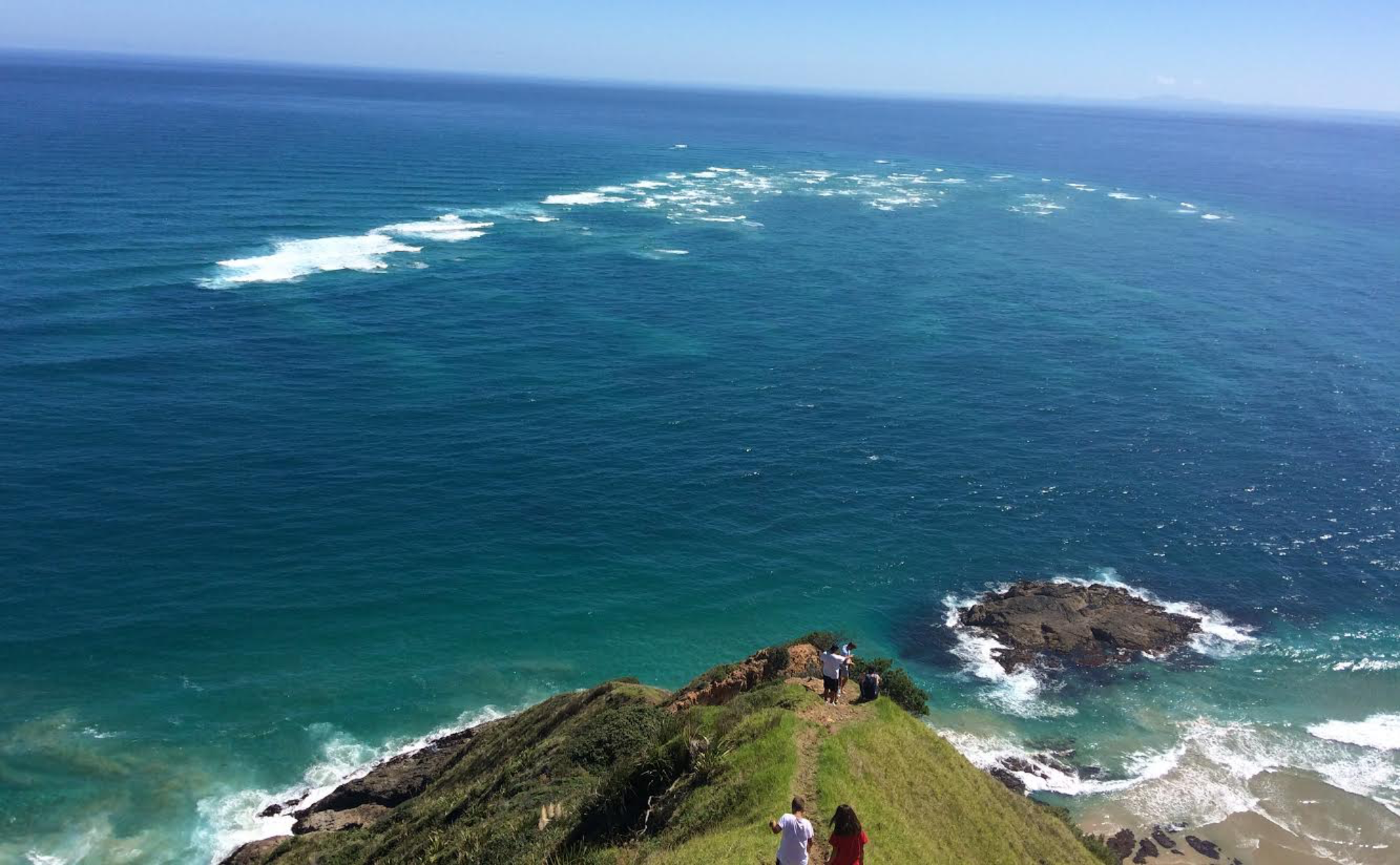
It’s a grey morning when we arrived at Orepuki Beach (Monkey Island). A freedom camping Irish couple were just leaving their beachside parking spot so we got good beach access to unload Secala and gear. My distant landfall (Sand Hill Point) is indistinguishable on the horizon, 30km away. This will be the longest open water paddle that I have ever taken on; to date. And in the middle of the Bay I will be the furthest (12km) I’ve ever been from any shore, in a sea kayak. All the forecasts are ideal though. A light following SE breeze is predicted in the afternoon. And I will enjoy whatever residual west flowing ebb tide through the Foveaux Strait; for a good portion of the day.
With Shaza’s help Secala is loaded to the gunwales with sufficient food and equipment for 18 days. It’s the heaviest she’s ever been. My previous longest solo trip was 7 days; from Te Araroa down the North Island East Coast; back in April, 2019.
All the usual pre-launch routines and processes kick in …….. PLB in left lifejacket pocket ………. InReach in right lifejacket pocket. VHF; Compass; Maps; Food; Tent; Primus; Fuel; Clothes; Water – check . Insect repellent – CHECK! Then, all too quickly we’re ready. Time to take a breath and realise that this is the moment that we have planned and prepared for well over a year. The launch that will take me towards the most remote and exposed coastline in NZ. It is estimated to take me 7 – 8 paddle days to reach my next rendezvous and resupply with Shaz at Deep Cove, Doubtful Sound. Who knows what part the weather will play?


At the last minute Shaz hands me double ziplocked bags of Christmas cake that I squeeze into the deck bag. A little extra water is required to detach Secala’s bum off the beach now.


After the launch there is the usual paddle wave farewell to Shaz before I turn to look for my landfall heading. It’s usually point to point. Clear and obvious. Or the compass course to find a land feature to aim for. Easy. But this time there is no land, or feature, on my bow. In the direction I need to go. Despite excellent visibility. My landfall is low lying Sand Hill Point, 30km away. Beyond the earths curvature. For now I would rely solely on the compass.
I ease into my paddle rhythm and focus my thoughts on the here and now. I feel the increased drag on Secala’s hull. A little like pushing into the next resistance level at the gym. About 30 minutes into the paddle I realise that I hadn’t checked the fridge. I have left behind the cheese and salami…….

Gradually the cloud lifted and the calm Bay gave way to a very gentle following SE breeze. Occasionally a large SW swell set would roll by, reminding me that we are actually in the Southern Ocean. They were reminiscent of the big rollers I experienced off Ninety Mile Beach. I managed to run right over the top of an unsuspecting shark seemingly resting on the surface. About 2.5m long. Not a midget. It bolted into the blue depths. My advantage of surprise. Need to keep it that way.
As I passed Mid Bay Reef, a recreational fishing boat, with 6 guys on board, came over for a chat. No doubt trying to figure out what a kayak is doing so far off shore! Nice chat but no offer of fish!

Approaching Sand Hill Point I knew I had to make a decision on whether to continue beyond the protected west side of Te Wae Wae Bay. There is a lovely protected beach just east of Sand Hill Point that looked very inviting. Otherwise my destination today would be somewhere along the exposed south coast, probably in the vicinity of Wairaurahiri River, that will certainly be a surf entry. And, more importantly, a surf exit tomorrow. The predicted swell height is only 1.5m from the SW. Which is very tame for this area. I decided to have a look on the west side of Sand Hill Point to assess the surf conditions.
At Sand Hill Point hundreds of Sooty Shearwaters were attending large fish work-ups. As I rounded the Point a local westerly 10kt headwind kicked in for a while but the swell looked low and manageable. It is all lowlands here with native bush right down to the beach. An amazing sandy beach stretches west from Sand Hill Point and there was not too much surf observed here. This sealed my decision to push on and find a suitable landing spot. In fact, beaches pretty much extended all the way to my landing spot. A helicopter flew overhead heading in the direction of Preservation Inlet. I hoisted my paddle to him.

At a spot that I thought was very close to Wairaurahiri River I came in close to shore to investigate and discovered a very protected Bay just east of the River. After landing on sand at low tide, I decided to stay, even though there wasn’t much room to camp above the high tide line. It would make a rocky bed tonight.
My introduction to Fiordland sandflies has now begun. I figured these sandflies hadn’t tasted human, in these parts, for some time. They had a few mates. They figured there was plenty of me to go round. The sandfly battle had begun. Decided I needed to mount some sort of defence. Some resistance or fortification. I can’t start our relationship with a whimper. I made a fire and stood in the smoke to get changed into dry clobber. I try to keep the smoke over my torso; not my head. I cough and splutter a little; but it’s worth it. The sandflies are largely kept at bay. I figure I win a points victory this round! There will be many more rounds to come. They are not going anywhere. And nor am I.
My next concern was fresh water. I needed to replenish my supply here. Or I would have to pull in somewhere along the way tomorrow. I wouldn’t get a full days paddle in with the water I had left. There was no obvious stream or creek nearby but I found a trickle of brackish water coming off an adjacent cliff. It tasted fine. Happy now that tomorrows paddle was sorted.


Have slept on a rocky base before; so knew my Sea to Summit sleeping mat would do the job.

While setting up camp, the helicopter was returning down the coast but this time very very low. Maybe 30m above the water and 200m off the beach. I expect he was on the lookout for me.


The first day of this South Island adventure. And all is well. Conditions are great; but that will not remain. Not in these parts. Every day paddled though, every mile achieved, is a mile that will probably never be seen again. Enjoy!
Monday 08 February – Wairaurahiri to Green Islets

Had a pretty reasonable nights sleep on the rocks. Can’t complain. The main disturbance was the high tide dumping surf on the rocks/boulders only a few meters away! Rose pre-dawn at 0500 to have my muesli breakie and pack up inside the tent by headlamp. Good to see the surf hadn’t changed overnight, despite the racket last night suggesting otherwise. Packed down Secala at first light and slipped easily through a small surf.
It’s another gloomy grey start to the day. But the sea is settled and the paddling easy. Settling into the day I get a real sense now of the remoteness and vast proportions of this place. It could easily be overwhelming. I snap out of it. Focus on the here and now. And what I can see. And control. There is more of a demand for contingencies, in these parts. An escape plan. As many as possible. In case conditions take a turn.
Today’s target destinations are either Green Islets (6hrs paddle) or Gates Harbour (8 hrs paddle). Both are selected for the all round protection they offer. From the adverse conditions expected from tomorrow. The obvious escape options today are Knife and Steel Harbour and Big River. During the paddle casual and continuous observations are made of other possible landings. If needed.

Where I end up today is where I will be hunkering down for a few days. Northerly gales are forecast for Puysegur.
I exit my calm Bay and round the corner to see a good sized bar and surf at the entrance to Wairaurahiri River. I’m even more pleased with decision to stay on my rocky beach last night. Long Point is the next prominent landmark. It looks a looong way off, yet by my reckoning less than 2hrs paddle away. My distance estimation, by observation, is a long way out.
Long Point demands respect. It has a lighthouse. For a reason. Rocks and shoals protect its shoreline forcing punters out wide. Green Islets is clear on the distant horizon as the next waypoint. Instead I cut in towards the shore to try and get a closer look at Knife and Steel Harbour. I find it; but observe many shoaling areas of turbulence and upwelling. The bigger swell sets break heavily over some. I get caught too close over one shoaling area and have to quickly turn to face an on-coming, and rapidly growing wall of water. The heart rate ramps in sync with the bow. Several paddle strokes up the face. Near vertical but safely over. A timely reminder. I retreat to deeper waters with my tail slapped.
The topography is becoming more significant. The land is growing now. Vertically.
Something breaches the water behind me and slaps back through the surface to jolt me back to the present. It sounds like a full breach as there is a time lag between the exit splash and the slap of re-entry. Maybe something after some little penguins that I saw moments earlier. I look for the telltale signs of dolphins, orca or whales. I don’t see or hear any. I’m left with my imagination. I’m more alert now and watchful of my surroundings. And I lift the paddle stroke rate just a tad. Create distance between me and whatever it was. I know it’s futile to out run anything out here. But it’s all I can do …… and doing it helps.
I enjoy the last of Shaza’s Christmas cake that has survived in its double ziplock bags. From now on my nourishment on the water will consist of Em’s Power cookies, nuts, dried fruit or a peanut slab. If I’m deserving! Would have enjoyed some cheese and salami …………..
A light rain now accompanies a light offshore NE breeze. Big River is the next conspicuous landmark adjacent to Prices Harbour. There are large rocky outcrops standing sentry at it’s entrance. The NE funnels down the Big River valley to give me a nice little assist on my starboard quarter; on the final approach to Green Islets.
Green Islets arrives and it’s stunningly beautiful. I weave through the cray pots, reefs and shoals on a smooth readable surface.
I land on a SE facing beach with ripples lapping the shoreline. The beach has vertical cliffs shrouding it from the SSW clockwise all the way round to the NE. Cosy, safe, stunning.

A transition takes place at the end of the paddle day. Ocean to land. Where to camp? Flat, relatively high ground is important. Above the tidal zone – crucial. Wind protection – desirable. Soft base for tent – optional, but nice. For an old fella. And where is the water supply?
But first, immediately before landing, the sand fly defences go up. I keep my head net and repellent in the cockpit. For quick access. First the hat and buff come off. Head net goes on with buff pulled over the top. Snug around the neck. Repellent is pumped onto hands and wiped all over the head net. Hat goes on. More repellent onto hands and wiped all over the remaining exposed skin – the wrists and hands. Good to head ashore now. And hope it’s not a wet landing.

The camp site pretty much ticked all the boxes, although there was light rain while setting up the tarp and tent. Tarp first. Erect tent under the tarp and move into position. Bring all dry bags under the tarp. Get changed by the fire. Make a coffee.
The most consistent water supply is found just beyond the arch about 300m away. It’s just a trickle, but the rain is coming.

Can’t complain! Got my 2 paddle days in before the expected northerly blast takes over. Glad with decisions to bring an additional Goalzero battery bank for charging the devices and with my MSR pocket rocket for a quick coffee.

Finishing each paddle day earlier in the day, after a 6 to 8hr paddle is part of the general plan. Ideally! To set up camp. Find water. And have a wander. To enjoy the journey. So far, so good.