9. Top of the South – Kohaihai Bluff to Cable Bay

A year later; we are back. And keen to finish off the West Coast. A nagging hangover from last year. Then ……. some solid progress down the East Coast. Hopefully. There are some hurdles to overcome though. Some of the most remote and rugged coastline in the country. And Farewell Spit.

But first – Kohaihai Bluff ………..


Tuesday 21 January, 2025 Kohaihai Bluff to Seal Bay

We made haste from New Plymouth to Kohaihai. The immediate swell forecast looks good. Required for a Kohaihai launch. With it’s fearsome reputation.

You also need a good 2-3 day forecast. This NW section of the South Island is rugged and remote. There are few known refuges. Few paddlers have taken it on. And those that have; have stories to tell.

At the completion of our trip here last year we identified a better launch location 2km south of the Kohaihai campground. The beach was not as steep. The shore dumpers were not as menacing.

The swell forecast now is 1.5m reducing to 1.2m. You can’t expect better than that around here. We parked at the Mossy Burn bridge lay-by to reaquaint ourselves with the conditions. At an equivalent state of tide that we would have tomorrow morning. It would be an ebbing mid-tide.

There is a nice “hollow” just beyond the shore break. Very handy. A place to dwell before taking on the destructive outer break.

But that is not all. There is a second outer break to contend with. Which becomes more prominent as the ebb recedes below mid-tide.

On the positive side; the shore dumpers should moderate as the tide backs away from the steeper section of beach. An ebbing mid-tide was shaping up to be a good launch period. As good as any.

Down the dunes and across Mossy Burn
Mossy Burn bridge and lay-by

There are two good paddle days left in this weather window. After that all bets are off.

Weather would dictate progress; ….. as always. With two days I should reach the accessible haven of Paturau River. There is a campground there. And Shaz can drive there via a 30km gravel road if needed.

Ideally though, we are planning to get to Fossil Point (Farewell Spit) on the third day; bypassing Paturau River altogether. This plan will have two remote overnight camps. At Seal Bay and a beach just south of Whanganui Inlet. I have no paddle intel on either. They are unknown as paddle destinations. I identify them both as possible landings while inching my way along the Google Earth coastline. They look great on paper. But who knows what we will be confronted with when we arrive. Or what the suitable alternative would be if they weren’t.

Seal Bay (Google Earth)
2km south of Whanganui Inlet (Google Earth)

I have packed Secala with several days worth of supplies. In case plans change. And we need to take refuge somewhere on this remote and rugged coast. Which is probable.

Today’s target though is Seal Bay; 7km south of Kahurangi Point. And conveniently midway between Kohaihai and Whanganui Inlet. About 6 hours paddle. I prefer to restrict my first few paddle days to about 6 hours. To bank some paddle fitness early; for the bigger efforts to come.

I was confident of getting out of Kohaihai today. They were my first impressions of the conditions. We have launched in harsher shore breaks before. But it wasn’t going to be easy.

The launch attempts turned out ugly. Uglier than they should have been. And took four attempts.

Paddlers familiar with heavy shore breaks know that selecting the setup location on a sloping beach is usually a key to success. There is an element of luck; with waves of varying intensity. Sometimes sweeping past you; sometime short. Additionally; Secala is well loaded and harder to manage. Once in the cockpit, a few seconds are required to secure the skirt and grab the paddle. And a few seconds is often all you have.

I get the first two launch attempts all wrong. I have set up too close to the sweeping shore break. Twice we get sucked into the maelstrom before we are fully prepared. We get smashed back on the beach before leaving it. It’s frustrating, tiring and time consuming.

Mid-tide conditions

On the third attempt, we get things right. And we’re through the shore break. We sit in the “hollow” behind it. And take the first gap that I see in the outer break. And get the timing wrong. There wasn’t a gap at all. And I have committed too far. Successive waves rear up in front of us. We rise up the first one as the crest was breaking. My chest and head get smashed backwards by a solid green wall of water as the heavy Secala ploughs through and over.

This momentary feeling of relief is dashed; as we flop over the crest, and gape at a second larger wave. Crestfallen; we take on the challenge. Despite knowing the outcome. The wave is already breaking heavily and will swamp us.

Like a defiant child; we paddle hard into the maelstrom ……. to be consumed and eventually spat out like a piece of driftwood.

More frustration. And more energy sapping time lost. We start over again.

Our forth attempt is pretty much perfect. And should have been what the first attempt looked like. Maybe. If I had shown a little more patience.

We are through the shore break again. More time in the hollow. A full swell set rolls through. We sprint out the lull without a problem.

Almost two hours are wasted. And I nearly lost my drybag of tent poles that somehow became unclipped from behind the seat. And recovered where they had washed up 30m along the beach.

The first major obstacle has been overcome. Beyond the surf breaks, the conditions are perfect. A paddle wave to Shaz and the adventure is finally underway.

Kohaihai Bluff

Passing Kohaihai Bluff and Scotts Beach; pods of Hectors dolphins momentarily drop by. Enough to sooth the mood and easing the pulse.

The Heaphy River arrives quickly. The pounding shore break continues unabated. Reminding us that these fully exposed ocean beaches of North Westland offer few safe havens.

We settle into our paddle rhythm on this spectacular coastline. The sea conditions couldn’t be better.

Four hours from Kohaihai, we close in on the prominent Wekakura Point. Large rocks extend directly off the beach that would offer good protection from northerly or southerly conditions.

Wekakura Point

Rounding Steep Point; Big Bay beach looks enticing in these benign conditions. Rocks Point at the northern end of Big Bay offers more dramatic shoreline to navigate.

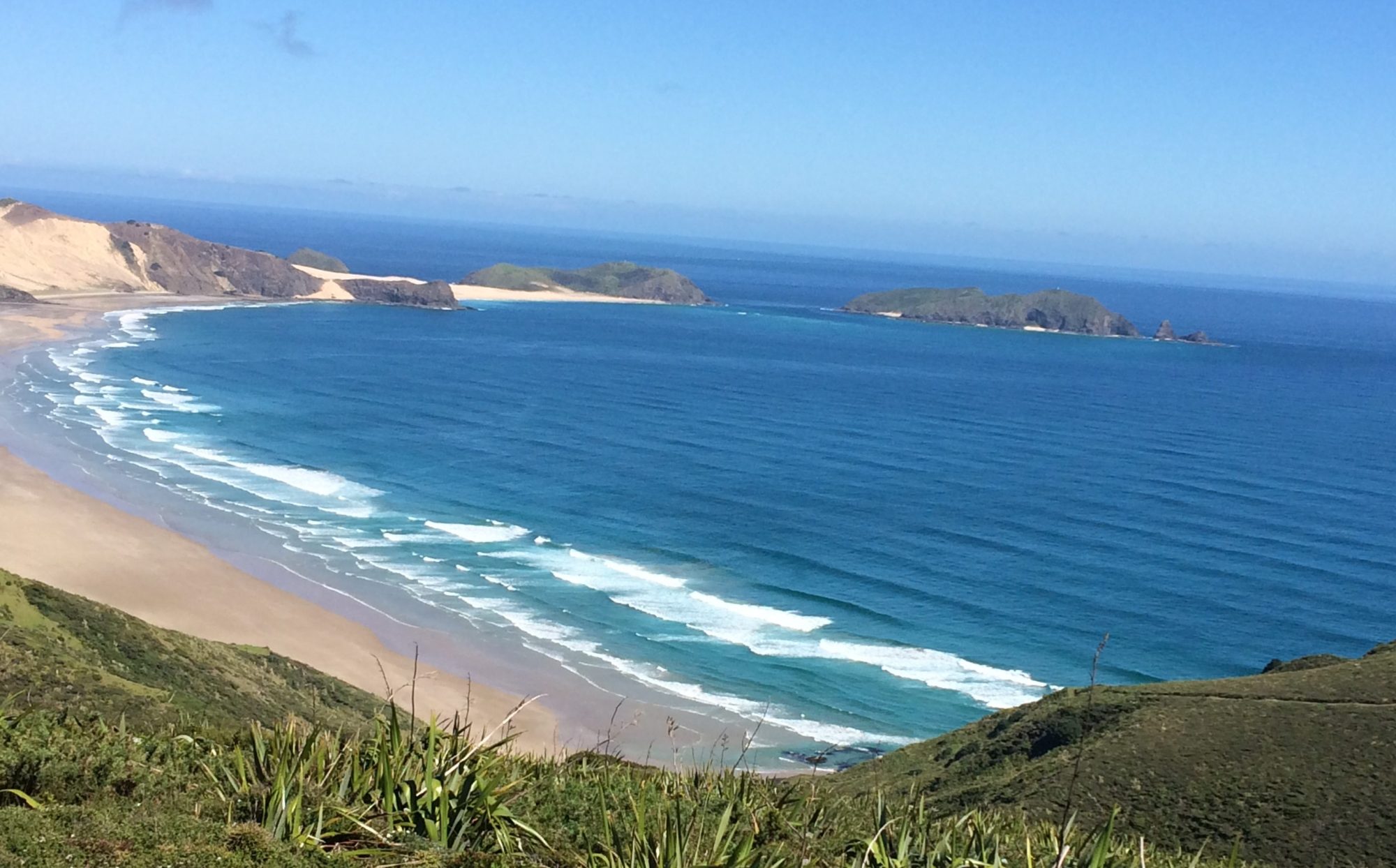
Around Rocks Point and the outcrop of Seal Bay becomes obvious. As we get closer I could see right through the sandy gap that seems to form an isthmus between the mainland and its promontory. Offering two potential approaches and landings at Seal Bay. One from south; or go around the rocks to approach from the north. I chose the northern approach. Much of the northern beach is exposed to the swell. More so than the southern approach. But we hug the rocks of the promontory and find a sheltered landing in its lee.

I am stoked. This placed has turned out so much better than I could have imagined. Remote; idyllic; beautiful. And all mine. There is no sign of recent human occupation.

Seal Bay
Seal Bay. Landed in the lee of the rocks.

I check out the entire beach. There are rocks that divide the beach in half. The eastern side is much more exposed to the westerly swell. And there’s a decent shore break. It has the only good water source with a steady stream of water tumbling from the rocky undergrowth.

The western end of the beach has an isthmus that offers a sheltered landing from both (north and south) directions. And a better camping option for protection from the west and south.

Camped on the beach. Mine are the only footprints in the Bay.

There is no sign of previous human activity. It feels like my very own discovery. Without doubt, one of my favourite locations so far on this entire NZ circumnavigation. And better still; there are no sign of sandflies ….. yet.

I take the opportunity to strip off for a swim and wash off the Kohaihai sand that’s got under the wetsuit. There is plenty of time to get re-acquainted with the old camp routines. And soak up the surroundings. I set about solar charging the battery bank; replenishing water; fresh water rinsing and drying the gear. Erecting the tent. Soaking up this stunning area and its wildlife. As the day wanes, a few sandflies do turn up. Not enough to be annoying; but enough to suggest that they probably have more friends nearby. 

I can be very content with the day. It’s been a long one. Dusk arrives as weariness set it. Kohaihai is behind us. No mean feat.  It was a beautiful paddle on a most stunning coastline. And concluded with a camp on a remote piece of paradise. What will tomorrow bring!


Wednesday 22 January, 2025 Seal Bay to Paturau River

Todays paddle destination is still undecided. It depends on tomorrow (Thursdays) forecast. It had been showing strengthening SW on Thursday; up to 30kts at Cape Farewell after midday.

My planned destination is another “Goggle Earth” discovery; 2km south of Whanganui Inlet. Similar to Seal Bay; offering a protected landing in the lee of a rocky shoreline.

This would be a 7.5hr paddle from Seal Bay. From there its only 4hrs to get around Cape Farewell on Thursday. If I could get around Cape Farewell by midday; I might beat the strong SW’lys.

Plan B is to come out at Paturau River. A shorter 6hr paddle. Where Shaz can drive to. And we can camp until the conditions improve.

Shaz is primed to send me an extensive forecast for Thursday via inReach overnight. I will make the decision on paddle destination in the morning. Whanganui Inlet (south) or Paturau River.

I rise at my usual 0430hrs. A good sleep considering. But a few aches and pains from yesterday’s hiding at Kohaihai. To be expected.

Soaked my breakfast cereal, made a coffee and read Shaz’s lengthy weather forecast. Which hasn’t got any better. Cape Farewell actually looks worse. Decided to make Paturau River the destination and told Shaz I would be on the water by 0700. No rush. Today’s forecast is good. And I only have a 6hr paddle instead on 7.5hrs. Shaz will have a bigger day than expected. With a long drive from Motueka with a 30km gravel road from Pakawau to Paturau River campground.

A very reluctant departure from Seal Bay. If there is ever a place to return to; it is here. Or be weather bound for a couple of days. But this is the West Coast. When there is a good paddle day; you take it every time.

It’s an easy launch. Within seconds we around the protective rocks and beyond the surf zone. What a contrast from yesterday.

Kahurangi Point soon comes into view. The lighthouse structure is much more majestic than expected. I was expecting something insignificant. Like Puyseguer Point or West Cape.

Kahurangi Point

The rest of the paddle is very enjoyable keeping as close to the shoreline as practicable; considering the numerous offshore reefs. Once we venture a little too close to shore and scrambled to meet a very large wave as it rose menacingly towards us. With its death rattle in progress. A few heart pumping seconds of hard paddling and we flop over the peak.

Anatori River campground

Paturau River eventually arrives. A little slower than expected; with the last 3hrs against light headwinds.

I see the top of the camper moving behind the dunes. Shaz has arrived and is soon at the top of the beach sizing up the best landing spot.

Paturau River

There are reefs to the south of the river mouth. Evidenced by rocks awash in the tide zone. The surf zone looks similar whatever approach we take. Continuous lines of tumbling surf. But nothing too menacing. We enter and ride the surf with a little too much complacency. And get flipped in the shallows. Unnecessary and annoying. But Shaz enjoys a good laugh. Nevertheless; another enjoyable day of solid progress on this wonderful coastline.


23 – 29 January, 2025. Paturau River

We are expecting to spend some weather days at Paturau. But the “weather days” have developed into a westerly storm. We decide to seek shelter back at the NZMCA park in Golden Bay.

Before we leave Paturau; Peter Hall introduces himself. The owner of the land around here, including the campsite. He stays in a caravan while renting out a couple of houses behind the campground. He’s impressed with our story.

On the 27 January we returned to Paturau to find heavy surf and strong SW winds. Conditions are forecast to ease over the next few days. The familiar waiting game on the West Coast continues. Twice daily I walk 1.5km back up the road to get cell reception. And the latest forecast.

Paturau River camp down the river
Paturau campground
Paturau River Bar

Finally, on the 29 January the swell conditions look good enough. And the NW winds are forecast to ease. We prepare for an early launch tomorrow.


Thursday 30 January, 2025 Paturau River to Fossil Point

All set for an early launch this morning. The forecast swell conditions are set to rise through the day. Paturau has a deceptive surf given any swell and tidal combination. The view from the top of the beach offer no glues for a preferable exit. The surf lines are continuous over the reef. But look relatively benign. And yet at sea level; in the kayak, they feel quite daunting. As we were about to find out.

A quick walk up to road to check the forecast. It hasn’t changed. The forecast swell is rising today from 1.6m to 2.0m. Providing some incentive for an early start. The tide has turned and the flood begun. We are set to launch at 0630. Although Shaz is apprehensive about my chances.

We launch behind the fully exposed rocks below the campground. The unrelenting stream of tumbling surf offers few glues for timing a breakout. It’s energy sapping and we’re getting nowhere. I become impatient and pay the price. The washing machine spin cycle picks me up and spits me out.

Peter Hall comes running down the beach from where he was watching on the hill. He offered some advise on the better launch spot some 200m along the beach. He describes a gap in the reef. Good to have that local knowledge. And an alternate option. But I suggest to him that I would give it another shot when the tide has had a bit more time to flood. Which will cover the reef a little more and take the heat out of the outer breaks. Hopefully. We head back to the camper for a cup of tea.

Waiting around isn’t a strength I possess. I’m itching to give it another attempt. Shaz says I’m crazy. And asks me for the passwords to my bank accounts.

The surf hasn’t perceptively changed. But giving it another go; we must. I figure conditions aren’t going to improve anytime soon.

This time success. Maybe I’m a little more patient. More likely a little more lucky. Whatever the case ………..we are out of Paturau River. And perhaps the last “real” West Coast launch. Shaz expresses disbelief on VHF. A paddle wave and we’re off.

Great to be on the move again after a week confined to barracks. The target today Fossil Point at the base of Farewell Spit.

The wind forecast is for essentially light winds through the day. There is a blanket of altostratus overhead; stretching to the northern and western horizon. There is a clear line of  precipitation and reduced visibility ahead. The sea is a little lumpy. Probably a relic of yesterday’s strong onshore NW winds. We pass the conspicuous Sharks Head that looks like an inverted sharks head with open jaws. Soon after that the outer breakers of the Whanganui Inlet become conspicuous. We drift out wide. It is the top of the tide now. We have made good progress through the flood. The turn of the tide will gather against us soon.

As we head north of Kaihoka Point the weather closes in. Rain showers are heavy; impairing visibility. The wind remains a steady 10kt from the west. For now. I am a little apprehensive that the weather may change; or amplify, as we close in on Cape Farewell. As they tend to do at all geographical extremities. I consider our refuge options. There is Wharariki Beach at the Archway Islands. But nothing much else. The coastline is rugged. Limestone cliffs grow in prominence to culminate at Cape Farewell. If we choose not to pull out at Wharariki Beach; Fossil Point is the only viable alternative. And only another hours paddle away.

The Archway Islands are much larger and imposing than expected. Yet provide some finesse and beauty to a dramatic and daunting shoreline. Caves in the cliffs have been carved out by the ocean. Booming emanates from them as the sets roll through. Adding to the drama of the spectacular landscape.

The sea conditions become much more sloppy as the bounce back opposes the sea state. I can also feel the strength of the ebb tide gathering against us now.

As we round the Archway Islands; Farewell Spit comes into view. The conditions are holding. And the decision is made. Fossil Point will be the destination. We round Pillar Point and line up the beach just to the east of the reef at Fossil Point. And ride a gentle surf onto the beach.

It has taken longer than expected to get here from Kohaihai. We have only paddled 3 days out of the last 10. Below par. But the successful completion of the formidable NW coastline cannot be snivelled at.

It’s time now to focus on the next challenge. The rounding of Farewell Spit.

Fossil Point (with Pillar Point in the background)

I stash Secala in the dunes and take the 20 minute walk out to Shaz at the car park.


31 January – 02 February Fossil Point (Pakawau)

Getting the conditions right for the Farewell Spit paddle will be important. It’s a big day even when they are favourable. We bide time at Pakawau. While Secala rests up in the dunes.

Secala in the dunes (Fossil Point and Pillar Point to the west)
Looking east down Farewell Spit
Fossil Point
Keeping active in the down time.

Monday 03 February, 2025 Fossil Point to Mutton Cove

I have looked forward with anticipation to this paddle. For a long time. Symbolically closes the chapter on the South Island west coast. Significant enough in itself.

The Spit has a mystique. An aura accentuated by its remoteness and access prohibition. On a global scale; it’s huge. 35km long. It’s a wildlife sanctuary and a place of regular pilot whale strandings.

Each side of the sand spit endure completely different marine conditions. The northern side contends with the harsh open ocean. While Golden Bay enjoys the buffer and relative tranquility. It is well known in the maritime world as a sanctuary for vessels; a safe haven from adverse weather.

My curiosity with this place is intense. What does the interface look like as the Spit delves below the sea surface? And the tranquil Bay clashes with the open sea. How big will the breakers be? How does the tidal range impact the observable length of the Spit? And the extra distance I may have to paddle. How will I know when to make the radical right turn towards Separation Point? Where the water depth transitions from tens of meters to just a few inches. And; how much wildlife will I encounter?

Nominally this is a 9-10 hour paddle. Around 55km. 5hrs to the end of the Spit; and 4hrs across Golden Bay to Separation Point. It’s still early days on this trip. I have only done 3 paddle days. And I’m not in top paddle shape yet. By some margin. 

I have contacted DOC to advise them of my intentions. There is a firm understanding that landing anywhere on the Spit is prohibited unless my personal safety is in peril.

Our plan is to make camp somewhere near landfall at Separation Point. Probably the DOC campground at Mutton Cove. If it’s not too busy. Then paddle the length of the Able Tasman to meet up with Shaz at Kaiteriteri. I plan to carry a few days worth of supplies; just in case.

The forecast is marginally better than it has been lately. Expect the early SE’ly wafting over the Spit; followed by a gathering NW’ly during the day. Peaking at 18kts this afternoon. Better than 25+kt predictions in recent days. It will be a cross wind. Over my right shoulder. When I eventually make the turn towards Separation Point; at the end of the Spit

Tides are also a consideration. LW today is 0800hrs. HW is 1400hrs. The tidal range is 3.5m. I was keen to coincide my arrival at the end of the Spit at; or close to, HW. My assumption is that more of the Spit will be submerged. Or further submerged. Maybe reducing the paddle distance to the turning point. I have been advised that the breakers can extend several kilometres beyond the visible end of the Spit. 

Also, the flooding tidal stream is easterly along the outside of the Spit. In my favour. It should be a cruisey morning paddle at least.

An early start is planned. For the 15 minute drive from Pakawau to the cark park at Port Puponga. And the 20 minutes walk through farmland, to the dunes. Where Secala remains stashed above Fossil Point. By the time we arrive at the car park; twilight has advanced sufficiently for me to dispense with my headlamp. 

In collapsible supermarket bags I carry the gear that I have recharged (VHF, inReach, phone, battery pack, GoPro); water and food. Secala is patiently waiting in the dunes.

Launch from Fossil Point

The tide is still an hour away from LW. There is a lot of beach between the dunes and the waters edge. A long way to drag a semi loaded kayak.

It’s an easy launch through low surf. For a pleasant change. Behind the breakers, we turn directly into the sun that is emerging over the Spit. The first sunrise that we have experienced for quite a while. A whisper of a SE’ly wafts offshore. We settle in for the first phase of the trip. To the end of the Spit. Where I expect to have the assist of tide and a trending NW breeze.

The paddling is easy along a baron sandscape. We stay as close to the shore break as possible. The predicted light (6-8kts) NW arrives by mid morning. There is a splattering of wildlife. Gannets, terns, the occasional seal on the beach. My only obstacles are the occasional outer surf breaks.

The most conspicuous landmark of the Spit arrives. The lighthouse amongst a cluster of trees. We are just over 4 hours from Fossil Point. Making good time so far. 

Farewell Spit Lighthouse

From here the Spit slowly recedes before submerging below the sea surface. It’s a fascinating thing to observe. The length of the Spit is out of proportion with its elevation. It looks like the tiny observable tip of a subsea behemoth.

The tranquil shallow sea state of the Bay is abruptly accosted by the turmoil of the open ocean. We are paddling within 20 meters of the demarcation. A continuous line of breakers extends ahead without visible end.

There is 3 hours of flood tide remaining. On both sides of the Spit. The breakers tumble on the ocean side; and disperse. Rippling over a few inches of water on the Bay side. The tidal zone on the Bay side is very shallow sloping. And covers a huge area.

Wildlife appears more prevalent in this tidal zone of the Spit. Flocks of gannets and terns swirl overhead. Shearwaters clutter the sea surface. On the submerged Spit, a seal rears up on its flippers; giving the illusion that it’s “standing” on water. 

The line of breakers continue. I can see the water depth slowly accumulating on the Bay side of the breakers. 

Separation Point is beckoning on my right shoulder. The temptation to turn is strong. Every paddle stroke I make further around the Spit; could be one that I’m making towards our destination.

There comes a point where the depth of water on the Bay side of the Spit will appear deep enough to cut through. But there is no telling if that water depth will be enduring. Over that huge tidal zone. 

The breakers continue ahead. With no observable end point. I recall Paul Caffyn’s advice “Go to the end of the breakers Brent”. And I know that this is exactly what I will do. I set aside any temptation to break through the surf zone. Lynn Paterson has advised that we may have to paddle up to 10km beyond the end of the Spit before turning into the Bay.

Sooner than I expect the line of breakers diminish in quantity and magnitude. The water depth on the Bay side appears more than sufficient for Secala and me. I decide to turn. A key moment. A leap of faith. And it’s a radical turn. A 70 degree course adjustment from 125 to 195. We sprint across the potential surf zone and over the shallow tidal area of the more tranquil Bay. The bottom is less than a meter deep. But comfortable. And after several minutes fast paddling; gradually deepens. We are in the clear and I focus our attention on the distant landscape. It’s 24km away; and featureless. We set a compass course for a more accurate landfall. 

There’s mixed emotions that the Spit is now behind me. I stop and look over my shoulder at the clump of trees at the end of the Spit. There’s elation and a good sense of accomplishment at a successful rounding. And some mysteries of the Spit revealed. The rounding marks the end of the West Coast. The sunsets will be displaced with sunrises.

Our destination; Separation Point, is now directly ahead, at last. The sea state changes dramatically over the next 20 minutes. The NW’ly that has been more or less astern; is now on my stbd beam. And escalating, as forecast. The westerly flowing flood tide into the Bay still has 2 hours left in the tank. Directly opposing sea state. It gets lumpy. During the next hour the winds escalate from 12 to 20kts. The sea state becomes intense and annoying. Even though I know Secala tracks very well in these conditions; I apply some leeway to be sure. The wind is pushing us offshore. And it’s a 4 hour trip across the Bay. On a good day. The sea chop washes over the deck of Secala constantly. There is no opportunity to rest. I’m grateful to have some “ballast” in the hull. In anticipation of a long day, I have made a point of frequently hydrating and nourishing all morning. More than usual. And the body is feeling fine.

At the top of the tide; the sea state eases to a more comfortable level. Even though the wind has escalated.

Separation Point is painfully slowly arriving. During the last hour the conditions ease further. Eventually Separation Point lighthouse becomes apparent. I have tried to pinpoint the lighthouse against the landscape a number of times. Thinking that it was more elevated. It eventually becomes obvious; and much closer to sea level than expected. My compass course and leeway have served me well. I say a big “Hi” to the Point; from Lynn Paterson. 

Separation Point (white spec mid right)

Immense satisfaction that a big and memorable day has been completed well. 

Mutton Cove and the golden sands of Abel Tasman.

A smooth landing onto a golden sand beach to finish the day. A long time coming. The South Island west coast has been overcome. This NW section has been a particular challenge. It is remote and inaccessible. The coastline is dramatic and difficult. Safe havens are few. Not many have kayaked this area. And little is known from a kayaking perspective.

And so; there is a sense now that the journey can continue more fluidly; with less complication. Less restrictions on surf, weather and safe havens.


Tuesday 04 February, 2025 Mutton Cove to Kaiteriteri Beach

Today was always going to be a cruisey day. Shaz will be waiting at Kaiteriteri after tackling the renowned Takaka Hill in the camper yesterday. Kaiteri is only 5 hours paddle away. And I have all day.
I rise casually; make a coffee and carry it along the 20 minute track to Separation Point.

Mutton Cove from track to Separation Point

Not surprisingly, there is no sign of low lying Farewell Spit from this vantage point. 

Separation Point


I pull out my phone to take some photos and realise I have cellphone reception. A few txts have congratulated yesterdays effort. 

A casual decamp and we are on the water just after 0900. There’s only so much aimless mooching that can be done. A light SE headwind eventually backs around to the NE. The Able Tasman is an old stomping ground from my youth. Boarding school tramps. And a training ground for more ambitious trekking adventures.
We linger and reminisce off some of the Bays like Bark Bay and Anchorage. And appreciate them from a different perspective. We gladly bypass all the beaches that are lined kayaks. Boats infest the waterways. It is still peak holiday period. And this is a very popular holiday destination. We are reluctantly back in the “real” world; apparently!

I shall return in quieter times; to dwell along this beautiful coast.

Cottage Loaf Rock
Tonga Island
Coffee break on a deserted tidal beach near Mosquito Bay
Pinnacle Island
Jules Point; Adele Island

We round Adele Island and our destination Kaiteriteri becomes obvious. As vessels of all shapes and sizes converge upon it.

Shaz has set up camp and directs me ashore through the bustling Bay. The Riviera of the South Island.

Kaiteriteri

Thursday 06 February, 2025 Kaiteriteri Beach to Cable Bay

After a layday; it’s an early start. The forecast for this 6 hour paddle is good until midday. A 20kt easterly headwind is expected this afternoon. An early start is called for.

We are at the waters edge ready to launch at 0600 in the early dawn twilight. And so are a queue of boats at the nearby boat ramp. It’s still too dark to be on the water in a busy bay. We wait 20 minutes for better light.

We clear the docile waters of Kaiteri Bay and into an equally passive Tasman Bay. Despite the conditions; there is a sense of urgency to get across the 35km stretch of water. The distant horizon is shrouded in ominous dark grey cloud.

Tasman Bay looking towards eastern shoreline

Yesterday I had established my compass course across Tasman Bay. I would need this even on a good day with perfect visibility. And we certainly needed it now. There is no discernible landmark on the distant horizon.

Soon into the paddle though; buoys of a large mussel farm provide ideal directional markers.

And fishing boat activity around the mussel farms added further distraction to what would potentially be a tedious open water paddle.

We keep up a good pace in the calm conditions. And it is the first paddle this trip where Secala is light. I just keep a little gear fore and aft for ballast. As usual.

About half way across the Bay, the landscape ahead starts to obtain some definition; through the grey haze. I can make out Pepin Is. My compass course had been perfect again.

About 14km (2hours) from Pepin a light rain sets in and the anticipated easterly reveals itself. The shoreline retracts behind a grey shroud. 

By the time we are just a few kilometres from Cable Bay, the easterly has only escalated to 10kts. And eases back as we enter the protection of the Bay. We have timed this paddle perfectly.

Arriving Cable Bay
Cable Bay

I see the top of the camper as we hit the rocky shore. Shaz has timed her arrival perfectly to.


Summary ……………

An outstanding first 17 days of this trip South. Kohaihai seems a long time ago. But there are times and places that are permanently etched. The beauty of the rugged, remote, unforgiving NW coast. Seal Bay ……..Seal Bay ……… Seal Bay. Petulant Paturau. Mystical Farewell Spit. And the tranquil Able Tasman.

There has only been 6 paddle days out of the 17 though. A poor average. Our experiences to date; along the entire North Island West Coast and the South Island West Coast (to Kohaihai), we have averaged 50% paddle days. That paddle day average will surely improve now.

Despite the relief of completing the West Coast; there is a sense of remorse that the most beautiful; remote and challenging coastline in the country is now behind us. From Green Islets to Farewell Spit. It’s been a journey of a lifetime. Where the soul has been nourished; Peace has been found; Beauty has been revealed; And frequent reminders that the present is all that matters.

It is time to focus ahead. The next segment though the Marlborough Sounds will have quite a different series of challenges. Surf breaks are substituted with tidal streams. French Pass; Cape Jackson and Tory Channel. And what a story they should tell.


7. West Coast (South) – Milford Sound to Okarito

I had completed the epic Fiordland journey at Milford Sound almost 3 years ago; on 12 March, 2021. The adventure resumes now. The second leg of the South Island circumnavigation up the West Coast. This coast has a reputation. Like its North Island counterpart. I can only expect a 50% paddle day average. My ultimate aim this trip is to clear the West Coast in the time I have available. But I have re-read Paul Caffyn’s and Lynn Paterson’s accounts of their West Coast experiences. There experiences verify that it’s unwise; bordering on arrogant, to presume such an optimistic target.

I have rekindled contact with Paul and Lynn (aka Red) for this trip. Their knowledge and support is so valuable and welcome. (And what an understatement that would turn out to be)

Paul Caffyn

Paul has been the key inspiration for my sea kayaking adventures that started in ernest in 2017. Since reading about his amazing circumnavigation of Australia in the Dreamtime Voyage; I have been captivated by the monumental hurdles he had to overcome to survive such a journey. And this was without the huge advantages that modern communications and technology provides today. The sheer audacity to conjure up this outlandish challenge; followed by the dogged determination and resilience to see it through; was inspirational. A pioneering legend in the world of kayaking.

Lynn (aka Red) Paterson

Not long before this whole NZ adventure began for me in 2017; I became aware of Redz amazing non-stop NZ circumnavigation. I read and dissected her blog. Page by page. On one level her stories told of daunting challenges; dogged resilience and determination. On the other; the sheer beauty and peace of a world that wraps around you like a spiritual cloak. Where you yield to Mother Nature in all aspects of your existence. That you disrespect at your peril.

I eventually mustered up the courage to call her; back then. When I felt worthy. Her strength of character and warmth was enveloping. Like a cloak. From the start, her guidance has been as uplifting as a tailwind; and as sage as an oracle.


Saturday 17 February, 2024 Deepwater Basin (Milford Sound) to Martins Bay

Shaz and I hit the road after work on the 14 Feb to meet the Cook Strait ferry on the 15 Feb. Milford Sound to Jackson Bay takes 3 paddle days. Solo. The best weather window that you can expect in these parts is 3 consecutive days. In a perfect world you would paddle out of Milford at the start of this window. Despite making all haste on the drive down the South Island; I would only have two good days this time. Got to be happy with that. On the West Coast.

We learn from a road sign at Te Anau that the Homer tunnel is closed overnight. Opens at 0600 hrs. Earliest we can hit the road in the morning is 0530 to meet the Homer tunnel opening time. 

The day has finally arrived. For both of us. The early starts. The intense scrutiny of weather apps and maps. Plans are made and re-made. Regularly. The only constant is change. Agility is key. And we are out of practice.

We exit the Cascade Creek camp in slumber; and get to Deepwater Basin boat ramp just as the early glow of dawn shimmers above the Darren Mountains to the east. Boaties were queuing up at the ramp. It was Saturday. And the forecast was good.

We set up Secala at the waters edge. To the side of the busy ramp. I have practiced packing Secala in the garage. I have some different equipment this time. Notably a new and bulkier Hilleberg tent. And a new sleeping mat. I will carry a spare sleeping mat now. I had figured through my solo Fiordland journey, that this old man who would struggle without one.

The tent replaces my previous MSR that didn’t handle the Fiordland conditions so well. The new tent is relegated to deck cargo, to free up hull space. I have packed for 8 days solo. For a trip that is forecast to take 4-6 days.

Calm conditions were forecast today and I will enjoy an ebb tide out of the Sound.

The waiting is over. I’m eager to get going. Farewells and paddle waves to Shaz as she pivots her attention on the next few days of her own solo journey in the camper. Towards Jackson Bay.

Leaving Deepwater Basin on the ebb tide

At 0725 I send the inReach message broadcasting that my trip has started. It’s an overcast and calm dawn. Wisps of cloud hang in the valleys and edges of the Sound.

Mitre Peak dominates the skyline. Returning overnight tour boats hover past the many cascading waterfalls on the north side. I pick up the tidal current and before long we slide past Dale Point to exit the Sound.

Approaching Dale Point on the right. Entrance to Milford Sound (Saint Anne Point) on the left

Yates Point becomes prominent 12km away. As we eased past the protection of Saint Anne Point, the 1.5m swell announces its presence. The safe haven of the Sounds are now officially over as Fiordland gives way to the exposed ocean beaches of South Westland.

Approaching Yates Point with The Haystack in the distance

I followed a line of cray pots about 100m offshore towards Yates Point which roughly marks half way to Martins Bay. The shoreline retains the ruggedness of Fiordland albeit without its vertical dominance.

Rounding Yates Point

Old habits rekindle. Like noting contingency landings; if the weather changed. There were actually beaches all along the way. The preferred landing before Martins Bay is Kaipo Bay. And it looks larger than I had expected.

Lion Rock and Ruby Beach
Lion Rock; just before Kaipo River

The overall trip was calm, uneventful and very enjoyable for the first serious outing in 3 years. Conditions permitted close shoreline paddling; with its breaking shoals. A wonderful way to kick off this adventure.

Leading into today I had a few questions about my paddle fitness and stamina. I am pleasantly surprised with the 40km effort today. There will be sterner tests to come. But I’ll take it.

Glad to come around into Martins Bay at 1430hrs. With plenty of time to set up camp.

The landing was easy enough through a small shore break at the southern end of Martins Bay. Where the rocky shoreline mets the sandy beach. 

My surf re-entry routines are exposed though. When I hit the beach I realised that I hadn’t removed my glasses and I hadn’t removed my sipper tube from under my paddle skirt.

I didn’t really notice the sandflies until I stopped moving. When they attached to me in their droves. They don’t appear as big or vicious as the Fiordland sandflies but they number almost as many. 

Sandflies not as bad as Fiordland.

Found a perfect site for the tent among the flaxes a couple of meters from the beach. The only down side was trying to keep the sand out of the tent. During my walk around later; I discover a better sand free tent site, but it is a further 80m along the beach. 

First use of new Hilleberg tent at south end of Martins Bay

The other routines fall into place. Charging batteries with solar panel, eating, sorting gear and taking walks. I don’t find any water in the immediate area. But I didn’t try too hard. I have brought plenty with me. Dusk approaches and the chores are done. 

The highlight of every day arrives when all that remains is enjoying the beauty and tranquillity of this remote and idyllic place. To experience the last vestiges of a world still unspoilt by humans. My biggest fear is that some day the adventuring will end.

Martins Bay

I look out across the sprawling bay on a wonderful evening. The images are perfect. I try etching them into my brain. Like I did at Green Islets. And Acheron Passage. I know I will never be back.

I read an inReach message from Red. She has checked-in. As supportive as ever. And will be there for both Shaz and I as our adventures unfold. So good to have her on board.

Very content with the first day back after 3 years. Tucked myself into my new Hilleberg tent as dusk dwindles to starlight.

Bedtime routines rekindled. First the sandfly slaughter. Breakfast, water bottle and pee bottle laid out inside the vestibule. Within easy reach through the insect mesh. Cellphone and headlamp at my left shoulder. And drift off to the sound of the surf. On my new luxurious sleeping pad.


Shaz

Morning everyone, Brent launched from Milford Sound boat ramp this morning around 7.30am. We were on the road by 5.30am, the Homer Tunnel was closed until 6am following road works. I’m now back in Te Anau where I’ll stay for the night. It’s so different now the place is buzzing. Shops reopened and tourists everywhere. I counted 25 buses heading towards Milford from Te Anau, crazy!


Sunday 18 February, 2024 Martins Bay to Barn Bay

Up at 0500hrs. The pack down routine of everything inside the tent begins. By headlamp. While my vacuum sealed portion of muesli, milk powder and protein powder softens up in bowl of water.

Nourished and changed into paddle gear; I exit the tent. By now it’s 0600hrs and the stars still lay claim to the dawn sky. What a beautiful day break. 

By 0630 Secala is stowed and we launch easily off the beach into the 1 meter shore break. The laden Secala has little freeboard. And is sluggish through the surf. That breaks right over the deck and into my chest. On three successive occasions.

The wet start could not detract from the perfect morning. Calm, gentle offshore breeze wafting out the Hollyford Valley and a cloudless sunrise over the Skippers Range. 

In a buoyant mood, I got into my work with more purpose and energy today. There are some mornings that you feel you could paddle forever. A good nights sleep probably helped.

A straight run across Martins Bay to the prominent Long Reef conspicuous with its rock sentinels. Big Bay looms around Long Reef. I have read plenty about it. It is 6km deep and 8km across. From Long Reef to Awarua Point. An exposed piece of ocean. With an earned reputation.

The calm conditions continued around Long Reef as Big Bay is slowly unveiled. Visually, from sea level, the depth of the bay is more impressive than its width. The distance off shore that I will be paddling is a little unnerving at first.

Of more immediate interest is the number of upwellings and shoal breaks just beyond Long Reef. And good size breakers randomly appear in the heavier sets.

As we got a little deeper into the bay, the offshore breeze backed around to the NE and lifted significantly. The short sea chop slowed progress. The going got tough and wet. It’s like Big Bay decided it had a reputation to uphold. No-one, it seems, is allowed easy passage across this Bay.

Conditions eventually improved as Awarua Point approached. The open water feeling of vulnerability dissipates. I swing past Awarua Point as close as I can. As always there are plenty of shoaling areas around these prominent Points.

In my planning for this leg; I had identified two possible landings north of Awarua Point. Hackett River and Ryans River. As I paddled by, I noted that these locations looked like good landings in these conditions.

Aptly named Longrigde Point, is only two hours paddle from Awarua Point. And just 40 minutes paddle beyond that was Gorges River. 

Gorges River has long held some fascination for me. I have read and seen documentaries about the Long family who live there. Robert Long for over 40 years. 

I was keen to stop in and say hello if possible. This opportunity is not likely to come around again.

The Gorge Islands mark the western approach to Gorge River. In flat conditions I pass easily between the islands and shore. The Long home is easily seen through a gap in the trees. 

Gorge Islands
Gorge River Valley

I hold for several minutes trying to identify the river entrance. There is a line of low breakers before me. I paddle slowly north along the shoreline. Until the entrance opened up. It was low tide. The river bar will be shallow. I lined up where I though the channel would be and shimmied over the bar. There was only inches under the hull. I landed on a stony river bank only 30 meters up river.

I nudged Secala into the riverbank and surveyed the scene. Feeling a little like an intruder. There was no sign of anyone around. No noise. No smoke. The house could barely be seen through the trees. Closer to the river mouth was a wind sock that had wrapped itself around its pole.

Gorge River mouth

Between me and the house were a some punga trees. There looked to be a barely discernible track meandering in the general direction of the house. 

I exited and pulled Secala up the river bank and headed through the pungas.

I emerged to be confronted by a high fishnet fence and a tall ramshackle gate shrouded in vegetation. I soon learn that this is to keep the deer out of the veggie garden.

Still no sign of anyone. The large gate was closed and unwelcoming. I still could not see or hear any signs of life through the vegetation. I call out. Twice. I hear movement coming from the direction of the house before a tall man emerges through the gate. Robert regards me with a little disdain. Like I have breached his personal space. Which I have, I guess. He lives in a remote place for a reason.

I quickly explain that I am just passing through on my kayak and thought I would drop in. I tell him that I have read articles about him and his family. Roberts demeanour softens. 

Catherine comes breezing through the gate and I readily accept her offer of tea. In their house we sit and talk. Robert sits on a bench at the window. Catherine brings tea and cake and joins me at the table. She clearly relishes the opportunity to chat. An outsider who has stories of his own. I ask about their children. Robert’s attention is spiked. And they both take the opportunity to talk with pride about the accomplishments of Chris and Robin.

The living area of the house is small by perfectly adequate for two. No need to cater for too many visitors. There is more to the house than I can see. But what I can see is a genuine attempt and deserved pride in living sustainably with minimal modern convenience.

Although there are a chasm of stories untold about their chosen lifestyle; I take my leave; siting another 2.5 hours paddle to Barn Bay.

Catherine gives me a shove off the river bank and joins Robert to wave me goodbye. I feel privileged to have met this remarkable couple. Who; in these days of modern convenience, find peace in solitude and comfort in simplicity. It’s a visit that is all too brief.

Visiting Robert and Catherine Long at Gorges River

The short shallow river bar is easy to punch through. With a paddle wave beyond the bar; I set course for Barn Islands that were conspicuous in the distance.

Arriving at Barn Bay

Barn Bay is much smaller than Martins. Yet more visually dramatic with its islands and reefs.

Barn Islands
Barn Bay with the Hope River at the southern end

A reef extends from Watson Bluff at the northern end; out into the bay. This provides excellent protection for landing at the northern end of the beach. I landed where the sandy beach meets the rocks of the reef. 

Sugar Loaf Islands (and reef)
Reef extending out from Watson Bluff to Sugar Loaf Islands (on a calm day)

I pulled Secala up past the high tide mark. A storm is brewing from the south. I survey the many campsite options. Ideally reasonable flat with protection from the westerly wind. And away from low lying areas that may flood. And preferably not sandy, like Martins Bay.

Camped beside over-turned dingy. And a calm Bay. (Awarua Point in the dim distance)

Eventually settled on a spot next to an overturned aluminium dingy that had been there for a while. 

The other consideration was water. There was nothing nearby. But the Hope River was an easy walk down the beach. I had plenty of water until tomorrow.

Spent the evening sitting on the dunes looking out over Barn Islands to a beautiful sunset. More wonderful images to etch in the brain. 

A message from Red. She is excited that I have landed exactly where she had.

Perfect evening at Barns

There is no paddle preparation for tomorrow. The two forecast paddle days were up. Targets have been made. And the body is holding up.

I plan to relax and enjoy a weather day in this beautiful place. Even in a storm. I snuggle into my Hilleberg tent. 


Shaz (Sunday 18 Feb)

Evening everyone update on Brent:- yesterday (Saturday) he kayaked from Milford Sound to Martins Bay. His message to me was “All good here except for the sand flies. Tent in the flaxes 3m from the beach”

Sunday:- he was on the water by 6.45am and kayaked a long way from Martins Bay to Barn Bay. He stopped at Gorges river and had a cup of tea with Long’s. If you look them up on the internet Longs from Gorge river you can read all about them living off grid and bringing up 2 children there. I have seen something on TV about them. I spent last night in Te Anau and now I’m in Cromwell for the night maybe 2 nights as the weather is not going to be kind to Brent for the next 2 days. Tomorrow I’m going to catch up with the Webb’s whom we worked for 2 years ago on their orchard. Weather is beautiful here, such a beautiful place really enjoyed our time here!


Monday 19 February, 2024 Barn Bay

The rain started during the night. But not the wind. I was well protected by Watson Bluff to the NW. And I was tucked just behind the crest of a sand dune to take the brunt out of anything from the south and west.

At 0400 I got up to have a pee and I must have startled a deer as there was a loud guttural bark nearby, when I turned on the headlamp. 

As the morning broke the wind backed to the SW. The cool and squally rain showers buffeted the tent. Even though I had some protection from the sand dune. 

When there seemed to be a break in the weather; I grabbed my water bottles and coffee kit and headed for the hunters hut at the south end of the bay. I emerged from the tent to a very different seascape. The swell was well up, as forecast.

The walk along the beach revealed a very different bay to yesterday. The ocean was wild and brown. The steep beach had menacing dumping waves. The sky was bleak and horizon threatening.

The beach is about 2km long. About a third of the way down the marshland ejects water into the bay. The water looked clean enough but figured that the Hope River with its greater flow, would offer better water. It didn’t. It was running brown after the rains. I was surprised as I figured this was a mountain river.

Looking up the Hope River valley after the rains
Hope River mouth

The hut was vacant and locked. A look through the windows revealed a real character setup. And well decked out with solar and gas. The airstrip outside the door was in need of some TLC. 

Hunters hut

Since I had no water to make a coffee at the hut, I headed back up the beach. Marsh water would have to do. 

As I headed home I watched a very dark horizon approaching over my left shoulder. I had 2km to walk. About 20 minutes. It was obvious that the horizon was gaining on me. I started to run. In the soft sand it was actually a combined run/fast walk. While carrying full water bottles and dry bags. The squall was almost upon me. Rain drops were wetting the sand and stones. And I was still 50m from the tent. Breathing hard now; my run was petering out.

The buffering wind was just touching down as I scrambled into the vestibule of the tent. Where I hunched as everything about got lashed with squally rain. This was the story of the afternoon. Outside was no place to be. 

I did enjoy watching about 20 Hectors dolphins though; working the shore break within 20m of the beach.

Cozy and warm in my Hilleberg with coffee and Em’s cookie and Kindle. And the sandflies had hunkered down too. 


Tuesday 20 February, 2024 Barn Bay

It blew hard from the SW into the night. Accompanied by frequent squalls of rain.

Daybreak revealed a calm bay but noticeably cooler. And the swell was up big time. Huge breakers right across the bay. It would be foolhardy to attempt a breakout in these conditions. 

Surf’s up
Flotsam from the storm

The high tide at 0900 might see an opening. If I could get out of the Bay, the paddling would be fine.

Had coffee and muesli watching the surf. Hectors dolphins were frolicking in the shore break within 5m of beach. Sandflies were scarce in the cool morning air. 

As the sun warmed the air, the sandflies returned with the familiar “tap dancing” on the outside of the tent.

Then another sudden change. At 1100hrs the wind had ramped up from the SW to 30kt. And really cold. After a beach walk I tucked up into the tent. The sandflies were tucked up again too. The wind continues to escalate in the afternoon. The bay is full on messy now. Went for a walk around the rocks at low tide looking for paua. Thinking that there would be easy pickings. But the conditions made it hopeless. Forecast is better for tomorrow.


Shaz. (Monday 19 Feb)

Evening everyone, well not much to tell you tonight as the weather for Brent has been awful! He sent me 2 small messages:- 7.30am “Glad I’ve got a good tent. It’s pissing down here”. 2.10pm Ok. It’s pretty stormy here but ok”. 

It has been a lovely sunny day in Cromwell, but a little windy though! Got some lovely fresh fruit from Webb’s orchard, some yummy peach’s, apricots and green gage plum so good! Nice to catch up with a couple of people still working there. Checked out my favourite cafe Fusee Rouge, still good and have the best cheese rolls ever! Tonight I’m staying at Lowburn freedom camp (free), should have come here last night never mind. Looks like I’ll stay another night here in Cromwell as I don’t feel like paying Wānaka prices. I’ll get up early on Wednesday morning and drive over to Jackson Bay; just over 3 hours away, all good though! Hopefully the weather will be better for him then.


Shaz. (Tuesday 20 Feb)

Evening everyone, messages from Brent today as follows:-

7.45am Huge swell this morning. No way out at the moment.

9.03am Ok storm last night. Fine today but heavy swell in bay. Can’t get out through the surf even if ok outside. By tomorrow swell should have dropped enough to get out. Otherwise should be nice day here. Been watching a large pod of Hector Dolphins in bay just 20m off the beach.

11.14am Been for walks along the beach to see what the storm has washed up. The wind has picked up again quite strong and very cold. Back in the tent for a while.

12.14pm Wind has really picked up now. Swell map report was right Shaz. Sunny but very cold.

4.16pm The wind is really strong here now 30+ knots. Swell high too. Hope it changes overnight especially the swell, are you in Haast now?                  

Well as you can see I changed my plans and decided to come over to Haast today. I’m staying at a POP (park over property) just a gold coin donation for the local St John’s, great idea. It’s sunny here and a nip in the air but very pleasant. Hopefully Brent will get out of Barn Bay tomorrow and get to Jackson Bay where I’ll meet him


Wednesday 21 February, 2024 Barn Bay to Jackson Bay

Dawned a beautiful clear crisp morning. The tent is heavy with dew. 

I was in no rush to launch today. Even though the storm may have passed; I knew a decent swell surge would remain through the bay. I needed good light to suss the breakout. 

Everything was pre-packed for launch yesterday. From a distance; at an obtuse angle, there was a hint of a gap in the reef break. A closer inspection was required.

The reef between Watson Bluff and Sugarloaf Rock completely absorbs the swell surge. The launch is easy. The same reef extends to the south of Sugarloaf Rock but is more submerged. The swell lifts and breaks heavily over and around it. 

From the south, the Hope River bar extends its breakers. They appear to join hands with the Sugar Loaf reef break.

Parallel with the beach, inside the seemingly endless line of breakers, is a channel of deeper water. Where the swell height is still significant but does not break.

I paddle within this zone to explore the breakout options. With only a couple of seconds at the crest of the swell I try to get a read on the line of breakers. I sit through several swell sets. Eventually figure there is enough of a gap for a breakout. With luck. Knowing that a larger set could come along at any time.

I assess my time to pull the trigger; and put the hammer down. I clear the break zone; but can’t really be sure if other breaks lurk behind. I continued to sprint for a couple of hundred meters just to be sure.

Relieved to be out. I send the routine inReach message. Next stop; Shaz at Jackson Bay.

Besides the swell, the sea conditions were fine. Breaking shoals should be the only concern.

As Cascade Point approaches an albatross swings by. Another moment of admiration for this wonderful creature.

Cascade Point is aptly named. Sheer cliffs with waterfalls tumbling over them. Majestic and picturesk.

The cliffs continue east for a couple of miles. I stay as close as the swell bounce back permits. It’s really sloppy. Both hands lock on to the paddle.

I approach the rocks to the east cautiously. I figure I can go inside them well enough. And ride a couple of nice waves through the gap.

A very memorable section of coast. Even though they were still in morning shadow.

The unsettling bounce back subsides; as I find deeper water on the path towards Smoothwater Point.

Smoothwater Point (foreground) and Jackson Head

I was quite weary by the time Jackson Head came around. The tide had a part to play in that as well today. 

Approaching Jackson Head
Jackson Head

Around the corner and Shaz is waiting by the camper.

Jackson Bay

There was a good sense of satisfaction that the first key solo leg was now completed. And in good time. The new gear has passed the test. With flying colours. And the body is performing well after the 3 year hiatus.

Most importantly, the journey has resumed. It has been missed.


Shaz. (Wednesday 21 Feb)

Evening everyone; Brent was on the water by 6.59am this morning, somehow he made it out and paddled all the way to Jackson Bay. He’s very tired and now in bed, complaining about all the noise 😂 around here! Lots of boats are going out to put their cray pots out! 

While I was waiting for him to come in I went for a walk through to Ocean Beach to see if I could see him coming. Sure enough after a 20 minute wait he came around the corner. Couldn’t get a close photo of him, but a nice one of the bay though.

Shaz walk out to Ocean Beach

Thursday 22 February, 2024 Jackson Bay to Haast Beach

Todays forecast was too good to miss. Even though I had just linked up with Shaz again.

A beautiful dawn revealed streaky cirrus invading the sky; giving way to alto at the horizon.

Loading up.
Streaky cirrus

Nice to be back to a cruisier launch preparation from the camper. And I would only have a fraction of the gear to carry with me now.

Perfect start to the day

The plan was to head for Haast Beach. Where there was beach access. I had no idea what surf conditions to expect. But there aren’t many good options north of here. You simply had to deal with whatever the ocean delivered.

I had previously asked Red about Mussel Point as a landing option. Which is about half way to Haast. Her response was brief and on point ……#@***^#……..(Translated) Mussel Point wouldn’t be an option. In any case, the forecast was too good to limit it to 3.5hr paddle. Days like today had to be taken advantage of.

I set off at dawn; with Shaz prepped to wave me down at Haast Beach.

The first hour was flat and easy going with a gentle off-shore wind on the starboard beam. 

Open Bay Islands are the only clear reference point on this uniform stretch of coast. They are 25km away and slightly on my port bow. There relative movement will be oh so slow for the first few hours.

The off-shore slowly backed around to a NE headwind and gradually increased to 12-15kt. The associated chop reduced my speed down to 2km/hr for the next 3 hours.

In the middle of the Bay a cray fisherman #608 detoured to come alongside to take photos. Not a common sight I guess. To see a kayaker in the middle of the Bay.

Finally reached landfall at Okuru where the river outlet created a messy sea state for a few hundred meters. Open Bay Islands are now abeam. The shoreline is nasty. Heavy dumping conditions along this stretch of coast. 

Thankfully the shore break appeared to settle down, as I got further north along Haast Beach. 

Hector dolphins joined me for a couple of km just outside the shore break zone. They are quite tiny; especially the juveniles. And playful in a reclusive way. Like shy children around a stranger. I cherish their company.

When I think I’m getting close to the Haast Beach access; I turn on the VHF and try to make contact with Shaz. We make contact; and my first question; as usual, is “Can you see me yet?”. I think I am closer than I really am. According to her the inReach tracker says I have some way to go yet!

There are no markers on the beach to indicate the access road. And there is no cell coverage here. Eventually I spot Shaz’s yellow flag waving.

She keeps waving the flag though. Even though I’m only 100m straight out in front of her. 

I am weary now. It’s been a tougher day than expected. Thankfully there is an easy shore break. Unlike what I observed off Okuru. And a smooth dry landing.

Shaz is still waving the yellow flag. Which I now realise is as much for the sandflies; as it was for my benefit haha.

Haast Beach looking north. In the distance is Tauperikaka Point
Looking south. Open Bay Islands over Shaz left shoulder
Beach access to the car park

It would have been nice to stay camped at the beach for the night as there is another good paddle day forecast tomorrow. But Shaz’s enquiries with DOC revealed that camping was not permitted there.

We loaded Secala and gear and headed for the Haast Motor Camp for the night. 


Shaz. (Thursday 22 Feb)

Evening everyone, well it’s the end of another day! Brent left Jackson Bay at 7.22am heading to Haast Beach to meet me for lunch and then maybe continue on a bit longer! However thats not what happened 😂 Before he left he said it was estimated to be 5 hours 54 minutes hours, but ended up taking 7 hours 20 minutes. His overall average speed 4 kilometres per hour, very slow compared to 6 kilometres per hour normally. Due to head winds and choppy seas. Haast Beach was dumping waves onto the beach, but Brent being the pro that he is coped very well. So he called it a day and we are now parked up in a holiday park (very expensive one + $4 for washing and $4 for the dryer) never mind. Brent will be back at it tomorrow morning and make the best he can as the weather is turning bad over the weekend. I went into Haast today to get some bread, there was nothing left at all. So I asked were they expecting any today and he said they only have bread delivered every Tuesday and Friday. We have it good at home thats for sure. I asked him how the locals get on and he said they put in a regular order for the week and freeze it.


Friday 23 February, 2024 Haast Beach to Whakahopai River

Back out to Haast Beach from Haast Motor Camp. The access to the beach is a 50m walk through the scrub. As always, I head straight out to survey the surf. Yesterday’s shore break was easy enough. Coming in. Getting out can be a different beast altogether. Thankfully not much had changed overnight.

Loaded up Secala with Shaz’s help and perfectly executed the launch through the small shore break into the calm water beyond. This is the first fully exposed ocean beach launch so far this trip. But it’s easy today.

Today could be a very short day or a very long one. Whakahopai River has an access road down to its river mouth. And is only 4.5hrs paddle. The next accessible landing was at Bruce Bay; another 6 hours paddle past Whakapohai.

The weather is forecast to deteriorate during the day with a storm coming through tomorrow. The next couple days would be off the water. I discard Bruce Bay as an option today.

Whakahopai River is the target destination. The key unknown was the condition of the road down to the river mouth. After launch; the plan is for Shaz to drive ahead to check this out before returning to rendezvous at the Ship Creek lookout. Which is 3hrs into my paddle north. Where we would discuss the options over VHF. Ship Creek would be the alternate landing option if Shaz found issues with Whakahopai.

I set off along Haast Beach which continues uninterrupted until it reaches Ship Creek at Tauperikaka Point. The monotony is broken by the welcome return of Hectors dolphins closer to shore.

Shaz waves me down at Ships Creek. She has discovered that the road access down the Whakapohai River to the beach had been washed out half way down; by a flood. A couple of months ago, according to local residents.

The choice was either to end the day at Ships Creek after only 3hrs paddling; or continue another 1.5hrs to Whakahopai River.

It was a line call. The benefits of continuing to Whakahopai were that the landing; and re-launch, were likely to be easier than Ships Creek. And I would be 1.5hrs further north. Every hour gained now; can be very advantageous down the track.

The downsides were the unknowns. I had no idea what the river bar, surf or shore conditions were like at Whakahopai. I would have to stash/hide Secala somewhere for a couple of days. Secure from swollen river and potential pilfering. Then walk up the river to meet Shaz.

I decided to take the punt. On to Whakapohai River while to going was good.

The paddle north from Ship Creek was amazing. The extension of Haast Beach ends here. Rocky formations feature along the steep shoreline past Seal Point, Arnott Point and Knights Point. The low swell and calm conditions meant I could weave through these formations along the way. A fascinating and enjoyable paddle. 

At Adiantum Bluff looking north towards Seal Point and Arnott Point (big rock in distance)
Arnott Point

Shaz makes VHF contact at the Knights Point lookout carpark on the cliffs above.

I see a couple of small pontoon boats amongst the rocks. With divers on board. And wondered where they had launched from on this remote stretch of coast. 

With high anticipation, I navigate the rocky shoreline that shrouds the Whakahopai river entrance. 

I round the headland to discover a beautiful and easy entry into the river. It was high tide. Coincidently.  As a consequence the river entrance was wider. And deeper. The river bar was mellow. What a welcome conclusion to the day. A hard right turn and up the river a couple of hundred meters until it braided. There were signs of a recent flood. Large uprooted trees occupied the middle of the river. And the river bank has been scoured in places. On the river bank near the mouth were a  couple of 4×4 utes with trailers. The boats I had seen had clearly launched from here. 

Whakahopai River mouth is below the headland (top left).
Uprooted tree from recent flood

Knowing rain was on the way, I pulled Secala well off the river. On the inside of a large bend. I also want to leave Secala out of sight. Losing any gear would be annoying.

Secured everything inside and tied Secala to a tree. Rain was forecast. But not in flood proportions. I hope. And she would have to survive a couple of days.

Secala hidden and secured for a couple of days

With a dry bag full of my more valuable equipment, I set off to find Shaz. Figured I’d leverage the local knowledge. And followed the 4×4 tracks up river. Making river crossings where they made them. Until I reached their river bank access up onto the road.

Where to access road is washed away

Another kilometre and there was Shaz waiting on the roadside near some dwellings. That turned out a lot easier than expected. An adventurous and satisfying day come to a close.

Off we went to Lake Paringa for a couple of days to see out the weather.


Shaz. (Friday 23 Feb)

Sorry everyone for not updating you lately, some places have hardly any internet or none at all! Anyway here is an overall update of Brent’s kayak progress.

Brent left Haast Beach and was heading for Whakapohai River mouth, I was to meet him at Ship Creek to give him an update of whether it was possible for me to get down to the river or not. So I drove to the road that lead down to Whakapohai river and stopped at the first house I came to as it appeared to be a private road with signs that said NO motorhome day or night. I drove down it anyway! I spoke to the old fellow there and he said it was a good thing that I stopped as the road had washed out last month due to river flooding about 100 meters down the road. 

Back to Ship Creek and report this to Brent via VHF, he decided to proceed anyway and would walk out to where I could meet him. He tied up the kayak way up off the river bank in a grassed area, then walked out to the old guys house where I was. The weather for the next 2-3 days was out of the question to paddle, storm coming through. We stayed at Lake Paringa for the next 3 nights.


Monday 26 February, 2024 Whakahopai River to Hunts Beach

Distance 36.5km Time 6h 24m Ave Speed 5.7km/hr

We are both up at 0530 today. For the 20km drive back to Whakahopai River. Followed by the stroll back down the river to Secala.

I had checked on Secala yesterday. After the rain. And replenished the water and food for todays trip. Probably to Hunts Beach all going well. Our rendezvous point would be Bruce Bay. 6 hours paddle away. And possible exit if necessary.

I wasn’t sure what to expect at the Whakahopai River mouth today. It was dead low tide. And the swell would be up significantly too. Predicted over 2m. After dropping me off to wander down the river; Shaz would have to go back to Lake Paringa for cellphone reception. To receive my inReach message. To know if I had got out safely. Or to figure out if I hadn’t.

I half paddled and floated Secala downstream. The river mouth was much narrower. And too shallow to paddle.

I sized up two alternatives. One was off the steep beach through some hefty shore dumpers. The other was closer to the slightly more protected river mouth with a much more chaotic swirling surf. I chose the later. More predictable. Despite the swell; the sea conditions were good. I only needed to get about 20m off the beach to be clear.

With a little luck; a successful launch. It always seems easy when it’s done. 

The stunning rocky coastline continues past Abbey Rocks to Tititira Head. Beautiful small sandy beaches tucked in between the rocky cliffs are exposed now at low tide.

On the way across to Heretaniwha Point a very large fish jumps clear of the water ahead of me; and summersaults in the air. I figure it’s a mako by the unstylish nature of the breach and re-entry. Any kind of dolphin would be much more elegant.

Buttress Point (foreground) and Heretaniwha Point (distance)
Bruce Bay is just around Heretaniwha Point (foreground)

As I rounded the prominent Heretaniwha Point into Bruce Bay a light SW breeze set in.

Bruce Bay was going to be our rendezvous comms checkpoint. And a possible exit. If the surf conditions were good. I was concerned that the surf conditions could make Hunts Bay challenging for both an entry and exit. The key consideration being the exit tomorrow.

As Bruce Bay opened up I fired up the VHF. Despite several attempts, there was no reply. There was about 3.5km between us. Which should have been OK with line of sight. I reached for the cellphone thinking Bruce Bay must be an important settlement deserving of 21st century services. No reception there either.

I made the executive decision to continue around Makawhio Point to Hunts Beach. Just 1.5hrs paddle away. I would just deal with the surf conditions that Hunts Beach served up. As usual. 

I figured Shaz would see what I was up to from the inReach tracker. Little did I know that Shaz was having challenges keeping up with my location due to the lack cellular coverage. She had to keep driving and back-tracking to find coverage.

Approaching Hunts Beach I tried again in vain to contact Shaz via VHF. And no sign of her on the beach with her yellow flag.

The landing looked ominous. There were a set of breakers 150m from shore as well as a tumbling shore break. The beach looked to have a shallow slope. After a lengthy observation I sussed a gap between the outer breaks. Getting through that was the key objective. I would deal with the shore break when I got there. I timed my run through the gap well and rode the shore break before a controlled broach onto the beach. I was saturated but well satisfied with the safe landing. I looked out momentarily and tried to figure out how I would break out tomorrow. The state of tide would make a big difference. An assessment best left for the morning.

Hunts Beach looking south to Makawhio Point
Cook Bluff in the distance

As I dragged Secala up the beach, Shaz appeared. She had had an adventure of her own trying to keep track of me. The camper was conveniently located at the top of the beach. There were a couple of houses nearby. There was no-one home at either house to ask if it was OK for us to stay. We decided to stay anyway. Laid all the get gear out over the driftwood and enjoyed a beer. It’s always so good to be able to park overnight wherever you land.


Shaz. (Monday 26 Feb)

Up early before sunrise to get to the river mouth so Brent could get on the water. I dropped him off and headed back to Lake Paringa. There I waited to make sure that he was able to get out OK and recommence his kayaking. At 7.49am got the email from his iReach to say he was on his way. He was determined to get to Hunts Beach today! I was waiting at Bruce Bay for him to go past but never saw him. Another place where there was NO internet, so drove back down the road to get some internet and saw that he was about to arrive at Hunts beach oops 😬 

I got there and he was walking up the beach asking where have I been 😊. It took him 6.5 hours, which is 37km.

Anyway walked around the houses to ask if it was ok to camp the night at the beach. I walked to 3 houses where people were living but no one home, weirdly the next morning still no one around! So we just parked up and settled in for the night anyway!


Tuesday 27 February, 2024 Hunts Beach to Okarito

The tide was further out on the shallow sloping beach this morning. The outer breakers looked menacing. But there was still a gap to exploit. The same one. And a good enough hollow behind the shore break to sit and time the breakout.

An easy enough launch through the shore break despite getting a drenching. And timed the run through the outer breakers to perfection. Starting to feel a little cocky. My paddle fitness was returning. And my surf nouse has been flawless, so far. 

Cook Bluff with Otorokua Point in the distance

Todays forecast was a light 10-12kt NE headwind; which would be OK unless light turned to moderate. Today is already a big day. 10 hours. Pesky headwinds could push my limits. I had loaded Secala with gear for a random overnighter if by chance I couldn’t make Okarito today. The was only one beach access at Gillespie’s Beach before Okarito. And this had a bad reputation.

Conditions started of with a light offshore before backing around to the NE. Thankfully it remained below 10kt.

Otorokua Point (Gillespies Beach around the Point)

I had an amazing time with Hectors dolphins today. They joined me off Gillespies Beach and stayed with me way into the bight past Galway Point. In typical fashion, their approach is like a timid child. Most often the appear at the limit of your peripheral vison. Or approaching from behind is common. When you are subtly alerted to their presence by their “blow”.

Once they are with you, there is an irrepressible urge to lift the pace. To engage with these beautiful mammals. To entice them to stay. For as long as possible.

So far this trip they have engaged in relatively small groups. Seemingly always in pairs. Or multiple pairs. This time I had upwards of 20 around me. They would take turns to approach from behind and criss cross in front of the bow. Then swim under and around Secala. They seemed so playful. Curiously their nose never seemed to break the surface. Just their blow hole and their back. Enough to see their ghostly grey underside through the water.

Without realising; I had kept up a decent pace for nearly 2 hours. Such an uplifting experience.

I decided I should stop. But not from weariness. There was so much more paddling left in the day that I needed manage myself better. I stopped paddling for a snack. And, more importantly, some fluids. In less than a minute the Hectors were swarming around me en masse. Maybe concerned for my welfare! More likely that they had lost their source of entertainment. And then, in a heartbeat, they were all gone.

I hoped that they would return as I resumed paddling. Alas, they didn’t.

The ocean turned grey with glacial water as I passed the Fox and Franz Joseph estuaries.

Fox glacier was very distinct from my ocean view and Mt Cook peeked out of the clouds occasionally.

View of Fox Glacier and Mt Cook
Gillespies Point

As I made my final course change at the Waiho River some weariness set in. With the high tempo paddling and a slight head wind for much of the day. 

Omoeroa Bluff (just before the Waiho River – outlet for the Franz Joseph)

I was on the home straight now with only 2 hours to Okarito. The wind had finally backed around to the NW making life a little easier.

Was pleased when Okarito came into view at Kohuamarua Bluff. We had stayed at Okarito before. I knew there was a dumping shore break even on a good day. And there were outer breaks to deal with as well. Yesterday’s 2m swell was predicted to increase. I prepared for a hard landing.

There was good cell coverage here so called Shaz. She had arrived at the campsite. I waited for her to come to the beach. To find a good landing spot and wave me in. There wasn’t one.

I packed everything down and battened the hatches. My pack down routine was well sorted now. 

I decided on a spot a couple of hundred meters south of the lagoon outlet. And to my surprise managed to time my run well enough for a safe landing.


Shaz. (Tuesday 27 Feb)

Brent was on the water early heading for Okarito, big day! I left as soon as he did! Just didn’t want to be at Hunts beach on my own, weird feeling!

Brent leaving Hunts Beach

So I headed for Fox Glacier. Wouldn’t you know it, nothing opens until after 8.15am. So I waited until Neve’s opened, ordered some breakfast and coffee. What to do now; so I parked up and saw a sign that said Lake Matheson 6km so decide to go and have a look. Heaps of tourists down there, Americans and Chinese by the bus load! I decided to do the walk to the View of Views lookout – 45 minutes. You look across the lake to Mt Aspiring and Mt Cook, they were visible surrounded by cloud though. I ended up walking around the whole lake 1hr 15min. That deserved a coffee at the cafe. 

Then I headed for Franz Josef to do all the home cores, empty waste water & toilet, fill water tank, rubbish, recycling, top up diesel and do some shopping as we were getting low on supplies.

Then headed for Okarito. We have been here before! There’s plenty of internet there 😊 yeah, just makes life easier with regular updates on Brent’s whereabouts. 

Brent came in 4.45pm, he paddled for 10 hours today and travelled 56km. He said that he was followed by a pod of dolphins for a good hour and half. When he stopped to have a bit to eat and take some photos they swam around him in a circle and under the kayak before disappearing. Okarito campground is really nice, with nice hot showers for $2, clean toilets and friendly hosts. It’s more like a DOC camp with upmarket facilities.


7. Beyond the Bridge – Matauri Bay to Pohutakawa Bay

28 December, 2018 – 05 January, 2019

This trips timing was solely geared around utilising the traditional leave period over Christmas and New Year to advance as far as I could down the coast towards Coromandel, weather permitting. Unsuitable weather did delay our departure from New Plymouth until Boxing Day when we made our way to set up base camp at Tutukaka. This would be our base for the next 6 nights.

After a day (27th Dec) in camp waiting out the persistent southerlies, we were fortunate to get on the water for eight of the following nine days and both of us were very happy to have advanced south of the Bridge at last, and put those travel woes through Auckland behind us.

THIS TRIP: Matauri Bay to Pohutakawa Bay 8 paddle days

Overall Distance 296.5 km Time 53.07 hrs Average Speed 5.6 km/hr


Friday, 28 December, 2018

Matauri Bay to Outu Bay

Distance 48.2 km Time 8.7 hr Average speed 5.5 km/hr

An early rise for the 2 hour commute to Matauri Bay. Encouraging to look down on calm conditions as we arrive.


1000hrs ……. the waiting is over ………… itching to get on the water now.

Rocky Point ahead and Cape Brett in the distance (top left)

Flat conditions for the launch with Secala laden for overnight camp. My intentions were to head for Deep Water Cove (just inside the Cape) for the night, where there was no road access.

Enjoyed light winds from NE all day. In the middle of the bay crossing I came across several large areas of discoloured water where dozens of petrels and JC (jesus christ) birds were eagerly feeding. I scooped out handfuls of these critters that appeared to be tiny krill. Largely transparent with clearly two eyes and overall no bigger than half a grain of rice.

A few of the jesus birds (White faced storm petrel) in the area. Cape Brett in the distance.

Approaching Cape Brett after 7 hours I decided to progress around the Cape and find a beach on the other side knowing there were options at Outu Bay, Te Toroa Bay or Whangamumu an hour or two paddle away.

Approaching Cape Brett and Percy Island
Cape Brett lighthouse

Enjoyed a paddle through the “hole in the rock” with no other traffic

Percy Island’s “Hole in the Rock”

Ended up at the beautiful and sheltered Outu Bay being enjoyed by a couple of anchored boats. Paddled alongside and nattered to a women as she was rowing her dingy around the bay. Landed at the larger rocky beach, now in the evening shade, but there wasn’t any flat grassed areas to pitch a tent so headed across the bay to a small beach still in the evening sun, hoping to find a better place to camp.

Protected anchorage at Outu Bay. Camped on beach across the bay (middle left of picture)
Sizing up my beach camp at about 1900hrs
Setting up camp on rocks above the high water mark
The next morning ….. showing the overnight high tide mark

The tent site options were no better here but could at least enjoy the evening in the last of the days sun. A dehydrated feed of spaghetti bog and a chat to Brett from the nearby anchored yacht. Glad to have a good sleeping mat between me and the rocks tonight.


Shaz ……………… Up early this morning, left camp at 7am for Matauri Bay just on a 2 hr drive. Oops, ended up by telling Brent to go longer way by 9 minutes! Never said as I had already told him to change direction once!! Oh well we got there in good time! Arrived at Matauri Bay, never went via motor camp this time not getting another $10 out of me! There is a large turning bay next to camp with a sign ‘No PARKING AT ALL TIMES’, needless to say we parked there unloaded and packed the kayak ready for Brent. Then I went and parked in the public car park and walked down to the beach to meet Brent! 

He was on the water by 10am! I left there and drove back up the road and turned left onto road by shop/cafe. Great views from up here, but no where to stop and park for photos; all privately owned homes, but I tried from inside the Ute (photos not too bad)

Matauri Bay with Cavalli Islands behind
Cavalli Islands

Stopped at Kerikeri and went to supermarket, OMG what a difference a couple of weeks make! It’s so busy people and traffic everywhere. On my way back to Tutakaka I decided that I’d go back via the Bay of Islands and have some lunch at Paihia. I thought Kerikeri was busy but not a patch on Paihia; parking is a joke hard to find; people driving round and round the car park! But not me someone pulled out and I pulled in!! Some good person even paid for parking for 1hr for several people leaving tickets on top of pay machine! Good day, enough time for me to get some lunch at the Craft Bar & Kitchen on the waterfront.

At Paihia
Paihia jetty

I thought I’d drive down to Opua and have a look to see if Owen Glen’s private boat is still docked here. Chris told Brent that Sam was head cook on board, sure enough it was still there. Apparently it has engine problems or something, I asked a guy who was about to board if Sam Sharp was onboard. She was; so he went and told her that I was outside. She was busy preparing lunch for 8 people so we didn’t have long, just a quick hello and catch up! Owen Glen was onboard with his guests. 

Shaz selfie with Sam
Ubiquitous ……… Sam (niece) is Head Chef

Back at camp and the place is really filling up now! Brent messaged me at 7.06pm to say he had landed at Outu Bay for the night! 


Saturday, 29 December, 2018

Outu Bay to Woolleys Bay

Distance 46.2 km Time 9.0 hr Average speed 5.1 km/hr

Surprisingly good sleep on the rocks despite waking twice during the night ……… and a peek outside to check on the rising tide!

Up at 5.30 to my usual “getaway” breakfast of muesli, banana and protein shake before decamping. On the water just after 7.

Beautiful calm clear morning. Couldn’t check my usual forecast apps without the internet however once settled on my way to Home Point the VHF nowcasting broadcast South 10kt dying away with NE in afternoon. However a southerly 8 – 10 persisted all day which accounted for a slower pace today.

Another beautiful coast though. Prominent Home Pt had a good surge around it and passed within a few meters of a couple of cruising sharks just off the point. One of them was rather large and thankfully paid no attention to me.

Approaching Home Point. Danger Rock and Rimariki Island in the distance.

Pasted within a few meters of some locals fishing from their boat but they weren’t at all friendly. The intimidating Danger Rock had a few fishing boats surrounding it.

Danger Rock

Although well hydrated I started to feel tired after 7 hours and passing Whananaki. After a bit of Christmas cake and a peanut slab I was all good to go again.

Titi Island just off Roimata Point
Motutohe Island just before the rounding to Whananaki

Passing inside Elizabeth Reef and line of sight to Woolleys Bay, I tried to reach Shaz via VHF. Wasn’t sure which of the beaches to head for until I got a lot closer. Another 9 hour day but less miles covered.

Arrived Woolleys Bay and short trip back to Tutukaka camp for the night

What a beaut bay. Later found out that my brother used to give surf lessons here back in the day. A surf school still operates on this beach. Nice to have only an 8km drive return to Tutukaka camp.

Woolleys Bay

Shaz …………. It’s only 6.15am and all is quiet in the camp, why aren’t you sleeping Sharon! At 6.30am I went and had a shower, first in gets the warm shower and no queue’s! The sun is pouring into the tent, gorgeous morning! Did a little bit of washing today, then I went for a walk into Tutukaka! Walked around the marina, some flash boats here lots of money, lots! Got a coffee and sat down watching everyone boarding a boat for some tour. 

Had a quiet time reading at camp while waiting for Brent to let me know where to pick him up. He rang and pick up at 3pm from Woolley Bay. Lots of swimmers and boaties here today having lots of fun in the water. One boat even drove down the road, onto the beach and straight into the water!

Brent got in around 4pm!

Routine of securing the deck before surf re-entry

Have a little picnic ready for him, as after 9 hrs paddling he might need it! 

Picnic ready!

Back at camp, unpack, sit and relax for a bit before getting dinner ready. Boy they have packed the campers in tonight!! A couple of guys here with bloody drones, very annoying for a lot of campers!


Sunday, 30 December, 2018

Woolleys Bay to Ocean Beach 

Distance 37.3 km Time 5.8 hr Average speed 6.4 km/hr

No rush this morning as theres only a 6 hr paddle planned to Bream Head and a small commute to launch at Woolleys Bay.

Another clear and calm day with easy launch. This is to good to be true. If the whole coast was like this everybody would be doing it.

Very enjoyable paddle close to bluffs and shoals around Tutukaka Head.

Tutukaka Head …….. (Taiharuru Head faintly in the background)

Cruised past Tutukaka harbour entrance dodging the flash boats and headed for Taiharuru point across Ngunguru Bay. Sent a txt to Shaz in case she was having a morning coffee by the marina.

Tutukaka Harbour Entrance

Rounding Tutukaka, the prominent and familiar Bream Head destination came into view.

A whisper of a northerly was welcome after yesterday which gradually increased to 8-10kts. So much easier paddling.

Approaching Ocean Beach …………. Prominent Bream Head on the left

Arrived at Ocean beach a little ahead of schedule. Surfers to the right and a patrolled swimming area on the left. Shaz guided me in expertly saying to head for “Rip” sign she was standing beside …….. while I was still 2k away! Caught a ride in at the bottom of a nice wave before bracing into the beach as it broke. Happy to stay in tact in front of a busy beach of on-lookers. Shaz was impressed.

Ocean Beach surf patrolled area
Surfers at north end of beach
Definitely a place to return

Only down side was the long drag of the Secala over soft sand to the car park. A place to return to for sure 


Shaz …………….. Not much chance of sleep in this morning, with the birds singing and the cows mooing! Went for early shower (at 6.15am) to beat the rush, another lady had the same thought! Put my 50 cents in, NO hot water bloody cold shower! Thought maybe I had put money in wrong slot (for shower next to me), knocked on the door and asked if she had hot water, her reply was ‘NO it’s f…ing cold…’! Not a good start to the day!

Rowdy calf

Very, very noisy calf can’t find its mum! Drove Brent to Woolleys Bay and he was on the water by 8.30am. Beautiful morning, just a few people walking their dogs along the beach, couple of joggers and a kayak fisherman just come in with his catch of the day. 

Easy launch at Woolleys
Whale Bay (adjacent to Woolleys Bay)

Photo above taken from Whale Bay carpark, looking down on Brent between the trees!

Went for coffee and breakfast at Schnappers Rock cafe and this van was parked outside, what can I say!! Went back to camp, and Daniel rang! He couldn’t get over how great it looked here, the sun shining and they are freezing in Paris! Never mind they’ll be here in 10 days time! Did a bit of reading before heading to Ocean Beach at the Whangarei Heads. About an hours drive, passing through some lovely bays and a good view of Marsden Point across the harbour. Brent arrived about 2.30pm at Ocean Beach, very busy beach life guards on duty. Waves dumping on the beach, but Brent mastered it no problem. 

Ocean Beach ………helmet for surf re-enrty ………….. wary of timing the kayak exit
Surf always looks different from the beach

Coffee at McLeods Bay on the way back to Tutakaka.

Weary but content after another enjoyable day on the water ……. and another Shaz picnic to look forward to.

Monday, 31 December, 2018

Ocean Beach to Langs Beach

Distance 24.0 km Time 4.2 hr Average speed 5.7 km/hr

A one hour ride back to Ocean beach this morning. Looks like another great day to be had on the water. Felt more at home launching through some surf and taking a couple over the bow today. Morning surfers bid me a safe trip.

Had spoken to Lynn Paterson about a possible arrival at Mangawhai. Although she hadn’t any first hand info she kindly got back to me with some good information from a kayaker friend she had who lived there. However, we later found out that there was a large New Years eve event being held there, so we decided to avoid this place. Lang’s Beach was the new destination.

Approaching Bream Head ………….. Taranga Island (Hen & Chicks Islands) on the left.

Rounded Bream Head to a calm Bream Bay until about a third of the way across when I saw an ominous layer of gray clouds rolling in from the west. Sure enough, within minutes, this brought in moderate SW head winds (12-15kts) and its associated chop. Turned Secala enough to put the chop off the bow for a smoother ride. Ground out the next couple of hours until the wind and chop abated as I closed in on the lee of Langs Beach. A bit of an unexpected grind today but glad to get across the open expanse of Bream Bay.

Clocked up my first 1000km on arrival on this leg in 27 paddle days at an average 6.13km/hr


Shaz …………. Later start today, leave camp at 8am, and arrive at Ocean Beach at 9am. By the time we pack the kayak and Brent’s drags it down to the beach; he finally gets on the water at 9.00am. 

Plenty of surfers this morning, the day trippers are starting to turn up and claiming their spot on the beach.

I stopped at McLeods Bay for coffee at ‘The Deck’ cafe, with views across the bay! 

McLeods Bay

I’m picking Brent up at Lang’s Beach today, as I have to go through Whangarei on the way I’ll do some shopping for Brent. He wants a flag for his kayak and some jandles as his broke last night! It’s a 40 minutes drive to Lang’s beach from Whangarei, heading south. Brent arrived at Lang’s beach about 2pm.

Lang’s beach ……. quick exit attempt

Well it’s New Years Eve, but I don’t think we will be up to see it in; too tired. We walked into Tutulaka an had a beer at the Fishing Club and then had pizza at the Marina Pizza Bar & Grill. 


Tuesday, 01 January, 2019

Langs Beach to Goat Island

Distance 37.0 km Time 7.0 hr Average speed 5.3 km/hr

January 1st and we are not in any hurry today. Packing up camp and leaving Tutukaka is another nice marker as we continue our march down the coast. A little tired of the travelling involved with the base camp strategy, we decide to use the comfort of a motel in Wellsford for a couple of nights that is central for the next couple of days paddling.

Didn’t start out from Lang’s until 1145. With a late start and the prospect of afternoon SW’lies, wasn’t sure how much paddling I would get in today. Although I do have the ability to hug the beach all the way to Goat Island, decisions will be made on the water today with possible exit points at Mangawhai, Te Arai or Pakiri.

Rounded the shelter of Bream Tail into a steady SW 12-13kts. Asked Shaz to check in with me from Mangawhai

Sentinel Rock off Mangawhai

Coming in close to Sentinel Rock and watchful of the surf at the Mangawhai bar I advised Shaz that I would catch up with her at the next road access at Te Arai Point.

Sentinel Rock guarding the entrance to Mangawhai

There were only a few accessible exits on this stretch of coastline so Shaz followed me to each one in case I was ready to call it quits for the day.

Sizing up Te Arai Point

Hugging the coast all the way to Te Arai with the wind and chop ahead of the beam was a pain and with 3 more hours to Goat Island I seriously considered pulling in here.

Chatted with Shaz on a crowded beach and decided that I would continue to Goat Island. The slight change in direction to Goat Island (about 25 degrees) put the wind and chop (gusting 15kt) more on the beam which made a big difference to the paddling effort. Hopefully it would remain that way till I got to Goat Island.

Got to Goat tired but pleased with the decision to push through. Looking forward to a motel bed!


Shaz ……….. Pack up camp day today, leaving Tutulaka after 6 nights!  Driving to Lang’s Beach for Brent to launch for Goat Island. Late launch today about 11.45pm, Brent wants to aim for Goat Island, but the wind is up! I’m going to drive to Mangawhai Heads to make contact on VHF and see how he is going!

Leaving Lang’s beach

OMG, Mangawhai is fair pumping, so many people parking is a joke! Again luck was on my side, drove straight into park as nice man said he was leaving, thank you! Had lunch at Sandbar cafe and had a little walk around. I was heading to the Mangawhai Surf club when Brent called on VHF to say he was just going past, no chance of park here, but I did see him going past from the ute! He said that he would come in at Te Arai Point as the wind was up! To get to Te Arai Point access is via a gravel road, so much traffic coming and going! The car parks are over flowing, cars parked along both sides of the road; one way traffic only – ridiculous!! I parked illegally and called Brent on VHF. I told him the situation, said I’d wait for a park! So many people in a small space; who would believe it. A surfer who comes here every day, said he’s never seen it this busy before! Patience eventually pays off, got a park in the main car park. Brent much closer, I told him the waves were big, great for the surfers though. Brent decided to go on to Goat Island after all! I went for a walk over towards the big rock as I saw a walk way over the other side! Saw a great water hole/ small for kids to swim safely! I went on over the hill and saw Brent come around the corner, called him and wished him luck! 

Te Arai Point beach

What better place to get changed, but on top of rock at Te Arai beach!

Safe swimming beach/hole for kids!

Beach on other side of rock at Te Arai Point

Crazy, jumping off rock into tidal pool! Arrived at Goat Island around 6pm, contacted Brent on VHF, but couldn’t see him!

Goat Island beach
Goat Island
Seagulls having happy time in pool of water

Landing on Goat Island beach around 6.50pm. 

Lama sculptures made from tin, awesome!


Wednesday, 02 January, 2019

Goat Island to Waiwera

Distance 42.7 km Time 7.9 hr Average speed 5.4 km/hr

Arrived as Goat Island was just getting busy for the day and launched between swimming kids at about 9.30. Intending to reach Army or Shakespear Bay on the Whangaparaoa Peninsula today.

Calm around Cape Rodney and easy paddling to Tataku point. Just an easy SW 10 headwind so far.

Cape Rodney

Plenty of tidal stream turbulence at Tataku. LW was at 1115hrs so had timed well the flood assist though Kawau’s North channel. There was a steep “wind against tide” chop through the channel. Still managed a good speed. Needed to be watchful of all the boats. Glad to be sporting my new flag.

Made for Takangaroa Island for a rest and lunch and discuss next strategy with Shaz.

Takangaroa Island with Kawau Island in the background.

Still unsure if I could make Army bay against the headwind now gusting 15kts. 

Continued to hug the shoreline down to Mahurangi Harbour in an attempt to get a better angle with the wind to maybe consider the 2 hour dash across Whangaparaoa Bay to Army Bay.  

There seemed no respite in a strenthening wind blowing parallel with the shoreline. After battling to Big Bay and pulling into the beach, I called Shaz to meet me at Waiwera.

Big Bay just outside Mahurangi Harbour. Hard to imagine a descent wind around the point. Saddle Island behind the boats.

A hard day at the office today. Glad to pull into Waiwera. As I approached the beach a guy asked me to go and check on his mate who had swum out to check on a snagged longline. Found him and he was glad to have a rest holding onto Secala. After clearing the line and starting to tow him back to the beach his mate arrived in a boat to pick him up.


Shaz ……….. Brent let me sleep in this morning, so quiet no birds, no cows and no other campers!! Then we had breakfast at Caffe Cozy, couple of minutes walk away.  Then we left for Goat Island so Brent can continue with this part of his adventure! Late start today, oh well! 

Looking down at Goat Island from Cape Rodney Road

Enjoying a coffee at the Sawmill Cafe in Leigh, before heading back to Wellsford.

I think if we’re all honest, we have spent sometime on or in the ‘Funny Farm’!!

Traffic through Wellsford at 12.40 pm, guess holidays are over for some folk! Had a relaxing afternoon at the motel, waiting for Brent to call to say where he wanted to be picked up! He rang at 4.50pm and said that he would be coming into Waiwera beach in an hour. I said that I’d leave now as traffic was bad! It was  35 minutes drive normally! Got to Dome Valley lookout and traffic came to a complete stop. We crawled our way through Warkworth, 45 minutes, so needless to say I was going to be late! Got there finally, Brent was waiting for me to tell him where to come in!

Waiwera beach, looking across to Auckland.

Landing at Waiwera

Once we were all packed up and Brent changed we had dinner at Sugar Loaf Waiwera before we came back to motel


Thursday, 03 January, 2019

Waiwera to Gulf Harbour

Distance 21.5 km Time 3.66hr Average speed 5.9 km/hr

Checked out of the Wellsford motel and headed to Cafe for breakie. Ordered eggs bene ………. which was a mistake! It was smothered in hollandaise out of a squeeze bottle. Coffee was good though.

Launched from Waiwera at about 8.40 and had the 10-12kt SW just behind my stbd beam which gave me an assist and good speed till I got to Huaroa Point at the end of the Whangaparaoa Peninsula. Hoping to make it at least to Takapuna today if I could escape the worst of the forecast SW’lies.

Rounding the peninsula the SW intensified to 20+kts. Called Shaz to say I was going to bail at Gulf harbour.

Entrance to Gulf Harbour
Definitely looked out of place in here.

Had a look around Gulf Harbour Marina before exiting at the “poor mans” boat ramp.

Boat ramp at Gulf Harbour.

Short day today but can’t complain with weather offering up 7 straight paddle days. Forecast tomorrow not promising – SW 30kts.


Shaz ……….. Up early, packed and drove to Waiwera beach. Staying at Takapuna tonight.
Brent looking like a clown face today with his zinc on his lips!

Clownface

Brent launched about 8.30am heading for Takapuna beach, so long as the conditions (wind) ok!

Heading for Whangaparaoa peninsula in the distance

Lovely drive around the coast to Orewa where I stopped for a while and looked around the shops on the beach front.

Orewa Beach

It’s been along time since I have been to Orewa, it changed a lot! It was always busy, but times that by 10! Parking in the town a nightmare! I got a takeaway coffee and muffin then found a picnic table down by beach.

Left Orewa and headed for Takapuna beach driving along SH25, then headed across to Browns Bay. Beaches very busy, so drove up to Waiake beach. Parked up and read my book for a while, until Brent contacted me an said it was hard work paddling today and he was going to come in at Gulf Harbour, on the Whangaparaoa Peninsula and he’d be there in 20 minutes. Bugger, I was 30 minutes away!never mind, back north I go! He was already up by the boat ramp when I arrived at 1pm.

Loaded up and headed for our motel in Takapuna.


Saturday, 05 January, 2019

Gulf Harbour to Pohutakawa Bay

Distance 39.6 km Time 6.8hr Average speed 5.8 km/hr

Forced off the water yesterday as the predicted SW 30kt for the Gulf played out. Today’s forecast was for early SW turning N during the day.

Earlier 0715 start today from Gulf Harbour boat ramp. Calm conditions in the gulf as I set off for the west side of Rangitoto Island. An 0800 HW meant I would be having an ebbing tide against me for the day. Made some enquires about going through Gardiners Gap on the east side of Rangitoto but the required high tide time didn’t suit today.

Kept a keen eye out for shipping that I intended to keep well away from. Didn’t need to worry about them so much as the speedy pilot boat that came unnecessarily close to me as I approached A buoy. Twats!

Some day trippers fishing off the stern of a large charter boat.

Shaz txt to say she was going over the bridge for the last time as I was rock hopping against a swift tide around the west side of Rangitoto. A real moment to savour for both of us.

Beacon marking shoaling at western extremity of Rangitoto

At the south end of Rangitoto I kept a keen eye on the channel that the Waiheke fast ferries were taking and gapped it for Brown’s Island when it was clear in both directions. Glad to be through these congested waters without any heart stopping moments.

Pulled into Brown’s Island for an early lunch (rice and tuna) and reassess the days destination. Had suggested to Shaz that I would meet her at Eastern Beach for lunch. The predicted northerly was now just kicking in so said to Shaz that I would save myself a detour and cut straight across to Pohutakawa Bay at Beachlands and that I would be there in about an hour and a half.

Brown’s Island with Rangitoto in the background.

The northerly increased to 12kt to assist me meeting my scheduled ETA with Shaz. This marks the end of this excursion north with some good miles made courtesy of some favourable weather. Can’t complain at getting eight out of a possible nine days on the water. Couldn’t happen on the west coast! We were both upbeat now about being south of the Bridge and some shorter return travel distances for a while at least. Next trip ……. across the Firth of Thames and down the Coromandel coast. Can’t wait!


Shaz ………… Early start today from Gulf Harbour! Brent set off around 7.15am for Eastern Beach. 

Just off the boat ramp at Gulf Harbour

Looking across to the Northshore

Just because you’re on holiday, doesn’t mean you can’t do exercise on your bike (set up like an Exercycle). 

Arrived at Eastern beach around 12.20pm, after doing a bit of shopping at Botany Downs. Brent contacted me a little after to say he had stopped on Brown Island for a snack and was going to go onto Beachlands rather than Eastern beach to come in! I went onto my sisters place waiting for Brent to contact me with a time to meet him. Got a text arriving at Beachlands at 2.45pm, and sure enough that’s when he arrived. 

Arriving at Pohutakawa Bay

This is his last day in the water, until he has a long weekend or leave! We stayed at my sisters for the night before heading home the next day! This is his last day in the water, until he has a long weekend or leave!