


There is a sense now that the slow start to this years trip can be rectified. The paddle day average can be redressed. This coastline is near a State Highway most of its length. Solo trips will be few. And small weather windows can be exploited.
Thursday, 20 February Marfell Beach to Wharanui Beach

The accuracy of the forecasts for Cape Campbell have been inconsistent these last few days. Sometimes reasonably accurate; other times completely off the mark.
Todays forecast was for strong NW early; possibility easing after lunch. Nevertheless we had prepared last night for an early launch.
I’m up at first light and conditions were perfect. The Cape is only an hours paddle away. Rounding the Cape would offer some protection from a potential offshore NW; if we stayed in close. And the shoreline looks like it offers plenty of easy escape options.
Glad that Secala was prepared last night. I want to make haste now. The beach was long and shallow. The flood has been in progress for just an hour.
The ultimate destination today is Kekerengu. An 8 hour paddle. The fickle forecast may have the last say though. There is an exit option at Ward Beach; just 4 hours into the paddle. And from Waima River, State Highway 1 hugs the coastline. Shaz will keep an eye on our progress from the inReach tracker.

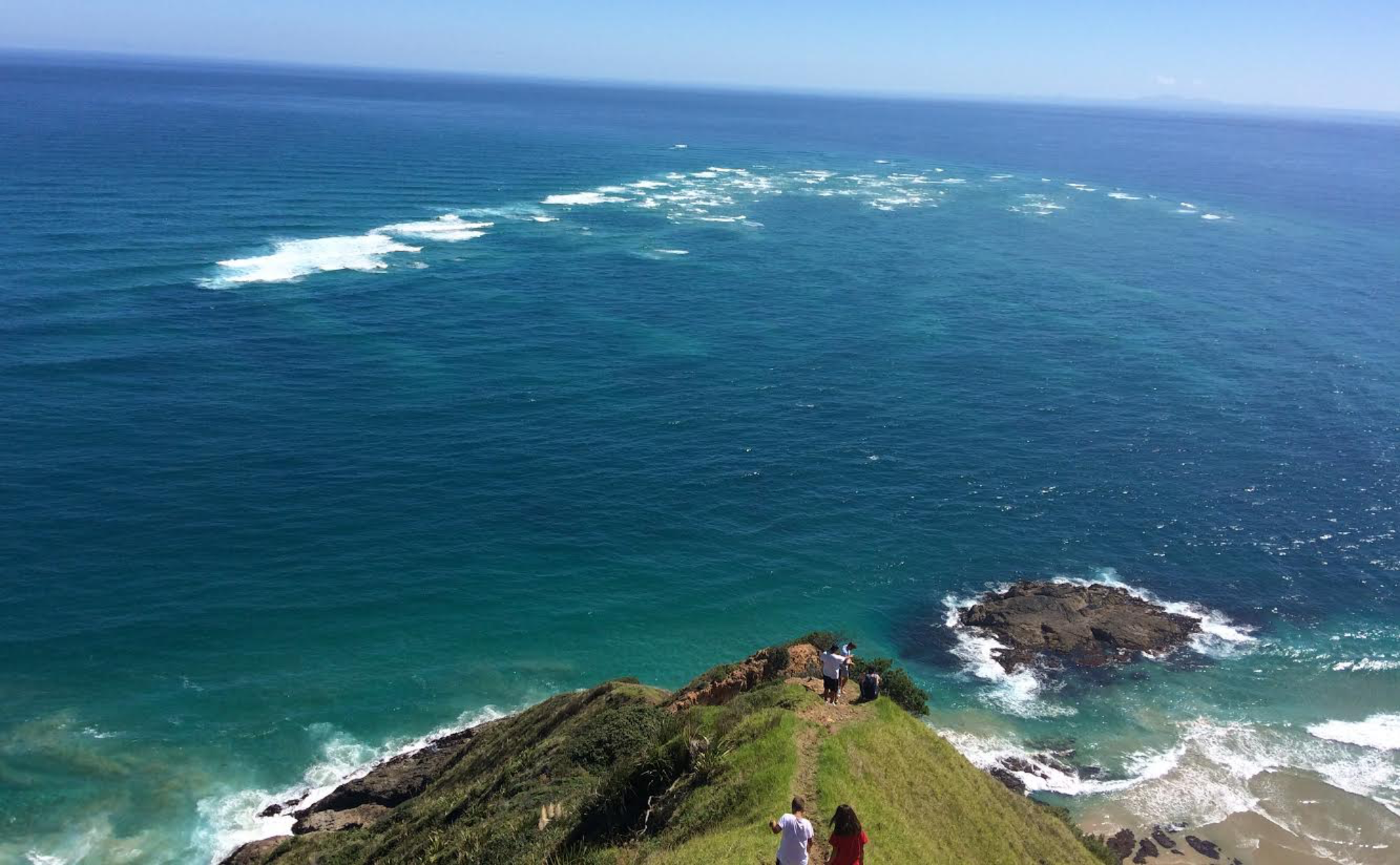
After an easy launch, we skim through the rocks at Mussell Point and aim for what appears to be a gap mid way down Bowler Reef off Cape Campbell. Many photos taken of the Cape in the diffused early sunlight.


The gap in Bowler Reef is good. We make a symbolic radical right hand turn. And a sense that we are now on the East Coast proper. Apart from the bumps at Kaikoura and Banks Peninsula; we are now heading parallel to the SW axis of the South Island.
Cape Campbell is on the periphery of Cooks Strait influence. And the further away from that that we can get; the better.

Smooth conditions remained as we weaved through Shepherdess Reef. Too soon we emerge from an enjoyable paddle through the reef; and continue on an unimpeded SW course towards Long Point and Chancet Rocks.


Paddling conditions remain excellent with a terrific coastline to enjoy up close. Telltale clusters of kelp stream along the sea surface. Marking reefy areas and a solid current against me.
Barron hill country meets a benign shoreline. There is an easy exit almost anywhere we look.
We are six hours into the paddle now and a blustery SW emerges out of nowhere. A very short and steep sea state, right on the bow, becomes untenable.
I see a small settlement about a kilometre away and we make a B-line for it.
Thankfully, we find shelter on the beach behind a reefy shoreline. My TopoMap says we are at Wharanui Beach. And there is road access.


I take a moment to survey the sea state that we have just escaped. The suddenness and intensity of the breeze reminds me of the Wairarapa coast.
There is a very strong NE a couple of kilometres offshore. Between that and the shoreline there is an opposing and strong SW wind that we encountered. I don’t think I’ve ever seen anything like it. Opposing winds of such magnitude; in such close proximity. I’m glad to be on terra firma.
There are some pine trees above the beach where I can stash Secala for the night.

Comfortable that Secala is well hidden within the trees; I grab the essentials and walk out about a kilometre to met Shaz on the side of State Highway 1.
Friday, 21 February Wharanui Beach to Ngaio Downs

We stayed at Kekerengu camp; 10 minutes south down SH1. Yesterdays unrealised destination.
Todays destination is Paparoa; 7 hours away and a good launch point for Kaikoura.
The forecast though, is for southerlies. Paparoa may not be achieved. Who knows where we will end up.
We drive back to Wharanui. Secala is waiting. Unmolested. We launched through a small shore break; weaved through the reefs and set off to rendezvous with Shaz at Kekerengu camp. Two hours later we reach Kekerengu and all is well.

SH1 remains coastal until the Clarence River delta; where is cuts inland. We set this as the next target and check-in point. 3 hours paddle away.
Dark cloud formations are looming ahead over the Seaward Kaikoura Ranges. The southerlies could be on their way. We lift the tempo with our time on the water now looking in jeopardy.
Signs of the southerly unveil slowly. Wisps and wavelets become more consistent. Then in quick order; escalating to an uncomfortable short steep sea state. With the wind ramping up just as quickly to 15kts. The dark cloud mass over the Ranges has now descended to sea level. The Clarance River delta is being consumed. And it is still 10km away. The winds preceding the front are inevitably going to get stronger. It is time to find refuge. The unprotected shoreline is 2km away. There are no reefs to dampen the shore break here. Any landing spot will be as good as another. And be close to the Highway. As we approach the shore I see Shaz and the camper pass by.
We land through the shore break and find a clump of pine trees to stash Secala. Shaz finds me on the inReach tracker and is parked not far away.

The TopoMap says we were at Ngaio Downs. A nearby farm track provides a convenient 200m walk access the where Shaz has parked.


Another day of the weather winning by TKO. But meaningful progress all the same. We head back to Kekerengu campground. This time 10 minutes north along SH1.
Saturday, 22 February Ngaio Downs to Kaikoura

An early start for a normal paddle day. Hopefully. The weather front has passed with a forecast of variable conditions this morning with Easterlies developing later in the day.
Shaz drops me back off at Ngaio Downs. There is little confidence in predicting a destination today. We plan to rendezvous at Paparoa about 4hrs into the paddle.
It is a cool morning. The front has delivered snow to the tops of the Kaikoura Ranges.

An easy launch through a low shore dump. But big enough to bury the bow and give everything a good wake up call.
Nice to see multiple pairs of Hectors dolphins this morning. But they keep their distance.
We come in close to the Clarance River delta with the Ranges providing a very picturesque backdrop.

Emerged from the murky river water around the delta and headed straight for the contrasting steep and rocky shoreline. Where the Kaikoura Ranges kiss the coastline for the first time.
Close in to the rocky shore between Waipapa Bay and Paparoa Point we enjoy a couple of exhilarating encounters with large pods of Dusky dolphins. Factions of the pods break away and frolic around Secala. Behaving like defiant juveniles. Play-acting and diving over each other seemingly to attract attention or outdo one another.
The forecast is holding true. We say hooray to Shaz at Paparoa and made a B line across Ingles Bay to the Kaikoura Peninsula.
Good conditions remained with a strong southerly current assist across the Bay. We were making excellent progress until the Ely breeze suddenly picked up to 15kt. Then; as we closed in on the peninsula, a weather tide effect took hold. The current from the north was being forced seaward by the curvature of the Bay. And directly opposed the easterly wind.
The sea state got very messy for a while; until we got close to the Peninsula where the edge of the current lane became very obvious. From blue water to green. And the weather tide sea state subsided as we broke out of the current lane.
Shaz made contact by VHF, from the shores of Kaikoura township, to confirm our destination of South Bay.

Upon reaching Keen Point; the settled sea state gave way to a messy bounce back aided by an escalating easterly. Eventually around Atia Point and found relief in the shelter of South Bay.

Shaz had picked out a good landing site. Good to get a full days paddle in at last. And a little tired after some unexpected testy conditions. Which is becoming a theme for us so far on this coast.


We load Secala onto the camper for the short drive to the NZMCA campground. We realise that it’s the first time this trip (since Paturau River) that we’ve had to load Secala onto the van.
Sunday, 23 February Kaikoura to Goose Bay

After much procrastination; I decided to launch into some messy Easterly conditions to Goose Bay today. Just 2 hours paddle away. It’s definitely not a day for a lengthy paddle. But figured I could grind out a couple of hours on the water. The purpose being to reduce the paddle time to Gore Bay tomorrow from 10hrs to 8hrs. Even though there are favourable conditions tomorrow; I didn’t want to take a chance on a long day where favourable conditions are unlikely to last the duration. Such has been our experience down the East Coast so far.
We paddle out of South Bay in a reasonably consistent but lumpy sea chop from the east. As soon as we reached the rocky coastline south of Peketa, the swell bounce back became annoying. We moved out deeper and around Rileys Lookout until I saw Shaz at Goose Bay. A clean landing through the shore dumpers. The rain arrives as we load everything onto the camper once again.


Monday, 24 February Goose Bay to Gore Bay

A solid forecast today. Winds from the NE all day. Less likely to get caught out with southerlies. With confidence we plan to get to Gore Bay.
There is no rush from our Kaikoura NZMCA campground this morning. The edge has been taken off this paddle day by yesterday’s hop to Goose Bay.

We slip easily out of the small Goose Bay dumpers and out around the Otumatu Rocks. Line up the spectacular Spy Glass Point an hour and a half away. Some pairs of Hectors dolphins show up but remain remote and peripheral.

Spy Glass Point holds my attention. It is an attractive headland. And as we get closer, there is an alluring beach on its north side.
From Spy Glass Point the Hectors dolphins decide they want to be sociable. From a single pair they quickly multiply as 4 pairs come and go over the next couple of hours. Like children with a limited attention span; they would come and play for 20 minutes; then peel away as if bored with the entertainment. Only to return a short time later.

The dominate Kaikoura Range is receding from the shoreline now. Lowland farm country of Hundalee and Conway Flat briefly occupy the coastline until the Hawkswood Range sends out its deep ravines to meet the coastline. We cruise within 100m of this interesting shoreline. The narrow beachhead is steep with shore dumpers. Not too menacing though. The NE 8-10kt conditions remain consistent. Life is easy on the water today. The distant bluff and Mt Beautiful, that mark the approaches to Gore Bay are slow in coming. The winds escalate as we enter the Bay. I spy Shaz arriving behind the dunes as we size up our approach to the beach. There are some outer breakers over some shoaling. We skirt around the edge of an outer break before catching a nice wave to the beach to finish the day off nicely.


We had decided yesterday that today’s paddle would be the last for this trip. A little earlier than expected. It’s off home for some recovery and planning for what I hope will be a final trip south to complete this amazing adventure.