

This stretch of coastline was always intended to be a solo trip. The outer Marlborough Sounds is largely inaccessible by road. French Pass is the only place that Secala and I will be going; that has road access. A long and winding road that we want to avoid. Shaz will meet me on the other side of the Sounds. Probably Whites Bay AGW. This will be the longest solo trip and the heaviest Secala has been since Fiordland.

The following days paddle from Whites Bay to Marfell Beach concluded this section

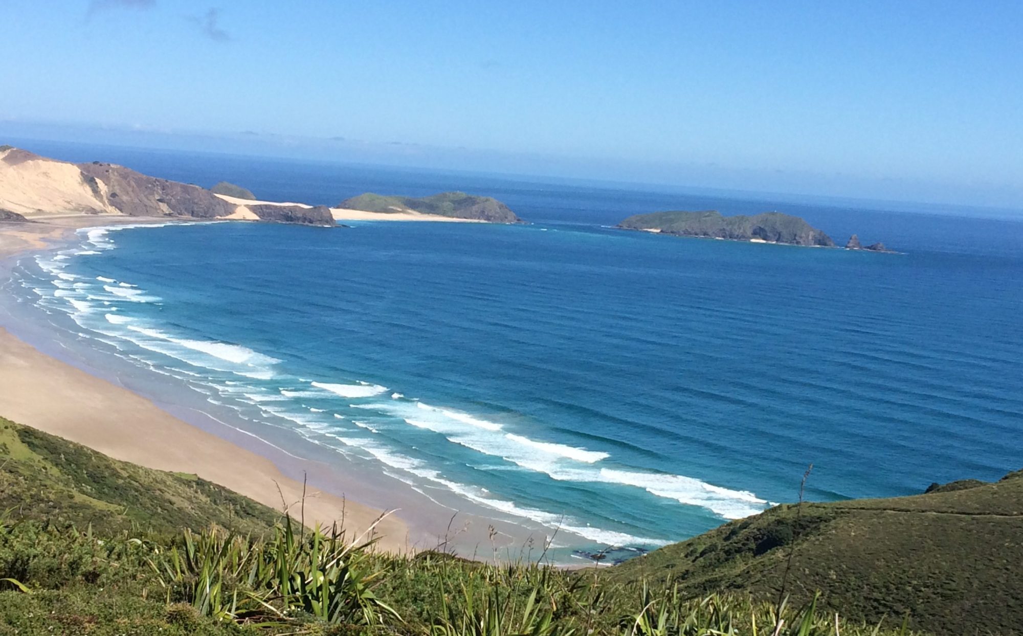
Saturday 8 February, 2025 Cable Bay to Otuhaereroa Island (Croisilles Harbour)

Planned a short day today; in anticipation of arriving at French Pass at the top of the flood tidal stream tomorrow. Due to strong southerlies forecast through Cooks Strait and Cape Jackson next week; I figured that French Pass campground would be a good place to wait and pounce on Cape Jackson, when the forecast came right.
I also expect that the French Pass campground would likely be full for the long Waitangi weekend. So splitting this trip to French Pass into two days made some sense.
As for today; we aim to be somewhere around the Islands at the entrance to Croisilles Harbour. About half way to French Pass. I have identified a beach just behind Kakaho Point. But there would likely be many camping options in the area. And we will have plenty of time to explore.
And so; a casual start today. We pack up the camper at the Cable Bay campsite and drive 200m to the rocky shoreline. We pull Secala to the waters edge and load her up. Shaz has got me some more freeze dried Real Meals from Nelson. My new favourite.

It’s a glassy sea surface. We should enjoy rock hopping our way towards Cape Soucis and the Islands of Croisilles Harbour.


Four cruisey hours later we weave through the rocks and reefs of The Islands at the entrance to Croisilles Harbour. What a contrast from the West Coast.


We tucked into a rocky beach just behind Kakaho Point. Unfortunately soon after settling in; the angry farmer “owner” came along on his boat and aggressively objected with me being there. And was not open for a sensible discussion.
It was still early in the day; so we relocated camp to the nearby Otuhaereroa Island. Apart from that episode; it was a very enjoyable morning on the water. And an angry little twat wasn’t going to spoil it.
A wonderful evening in a most beautiful location. With no sandflies. And very good cell service to check weather forecasts.

Sunday 9 February, 2025 Otuhaereroa Island (Croisilles Harbour) to French Pass

There is much anticipation of the transit through French Pass today.
It is probably the most infamous navigable tidal channel in NZ. Along with French Pass today; we will be transiting the tidal streams at Cape Jackson and Tory Channel in the next few days.
For a kayak, utilising slack tide in these areas is the only sensible option. Particularly for the first time.
Todays flood (NE) stream through French Pass is predicted to start at 0629hrs; and the ebb (SW) stream at 1144hrs. My plan is to catch the slack at the top of the flood. Before the opposing ebb stream gains momentum.
We are up and on the water at 0640hrs. It’s only 3.5 hours to French Pass, so we will arrive early. I hear there is a beach on the south side of the Pass. Where we can pass some time and hopefully observe the tidal race.
It’s a beautiful clear morning. As we clear the Islands a NW crosswind whips up to 15 knots. Earlier than expected. The paddling is on the slow side until Okuri Point; when the flood stream assist starts to take effect. We cross Waikawa Bay and into the Current Basin. The crosswind subsides in the lee of D’Urville Island; and the flood stream takes hold. We reach 8km/hr without much effort.
It’s only 0930; we’re 3km away from the Pass and can hear the roar of the tidal race already. The flood will be in full flight now. And it sounds intimidating.
I’ve not been to French Pass before. But I know its reputation as a treacherous stretch of water from my maritime background. We cautiously approach on the south side of the Pass. Looking for the beach.
Half an hour later we can clearly see the impact of the convergence. We approach on the southern edge of the tidal flow where the beach becomes apparent. There is a small rocky nook closer to the edge of the tidal race. We tuck in there hoping for a better view of the Pass. But there isn’t. So we take refuge on the beach. I can see the outer edge of the tidal race as it constricts towards the gap. It wasn’t an ideal view. But should be good enough to see a slackening of the tidal race at its outer extremity. (I realise later that there is a short track up from the beach that will lead to the Lookout track for a much better view of French Pass)


We wait for an hour and a half. Three other kayakers approach from the south. They tuck into the same rocky nook that we did. And out of view.
The flood stream is definitely diminishing now. And the predicted time for the ebb stream had arrived. We launch to get a better view around the point. The three kayakers had left the rocky nook and must have gone through the Pass already.

Even though the narrowest point of the Pass is still obscured; the tidal flow has waned significantly in the last 15 minutes. The slack can’t be too far away. We commit to the last of the flood stream. The transit is swift in pace and duration. Within touching range of the rocky shoreline it took 4 adrenaline filled minutes to get through the Pass. We swung out of the main flow just on the north side of the Channel Point lighthouse. Much quicker than expected. My GPS clocked 9km/hr without much paddle assist. It turns out to be a bit of an anti-climax really. Which is a relief.
Ten minutes later we swing around Collinet Point to the beautiful vista of Elmslie Bay.
And land on the calm, golden beach under the French Pass campsite.

The campground above the beach is still evacuating after the long weekend. It is only midday. I found a quiet corner to pitch my tent. We could be here for a few days. The strong southerlies are still predicted at Cape Jackson.

Bumped into Bevan Walker (we met at the Landing Shed at Puysegur) who had just completed a paddle around D’urville Is. And was one of the three kayakers who had just come through the Pass.
Information: My observations were that the actual time of the slack appeared to start at the predicted start of the tidal stream; with the slack lasting up to 30 minutes. The predicted tidal streams can be found at https://www.linz.govt.nz/products-services/tides-and-tidal-streams/tidal-stream-predictions
French Pass
We spent a very relaxing 3 days at French Pass. There’s usually something going on to take your interest. A small vehicle ferry runs frequently out of Elmslie Bay to D’Urville Island. And the boat ramp is often in use. Just beside the campground, visitors are attracted by the three resident stingrays that constantly patrol within a meter of the shoreline.
I walk up the road a couple of times a day to just sit and watch the tidal stream. Often boats; usually under-powered yachts; struggle against the tidal flow. With some having to abort and turn back around.
I have found a spot on the hills behind the campground where there is acceptable 3G cell reception. Where I can check weather forecasts. And contact Shaz. Who is having water pump issues in the camper van. I’m gutted to have left my fishing line behind, with so much time on my hands.
The Cape Jackson forecast stays true for the next few days. 30 knot southerlies. It’s fine at French Pass though. The biggest problem I have are the cheeky wekas. They steal anything with a scent to it. From soap; toothpaste and coffee. Even unopened freeze dried meals. And they have no qualms in entering your tent. I resort to hanging as much gear as possible in the trees.
We intend staying in French Pass until there are two consecutive paddle days available. The key reason is the lack of water. This area of the Sounds is largely open dry stock farmland. The land is parched and crunches underfoot. There is little prospect of replenishing my 2 day supply of water until we reach Queen Charlotte Sound.


Thursday 13 February, 2025 French Pass to Alligator Head

In similar fashion to the approach to French Pass; I plan to set up the rounding of Cape Jackson with the HW slack at 1100hrs tomorrow. In this case though; the ebb (SE) stream will be in our favour; so being late for the slack won’t be so crucial. But not too late. We are in the middle of spring tides now.
In easy conditions we round Clay Point, Paparoa and Culdaff Points to the south side of Alligator Head. We stop at a couple of likely camping options along the way. But continue to a beaut spot on the south side of Alligator Head.


As anticipated; there is no water. The area is totally parched. I make a point of using my primus well down the beach; in the wet tidal zone.


Friday 14 February, 2025 Alligator Head to Blumine Island

Up a 0500. It’s going to be a longer paddle day but no reason for an early start. We have to wait till 1100hrs for the slack at Cape Jackson. And it’s less than 3 hours paddle away. There are no tidal stream predictions for Cape Jackson. So I’m assuming a conventional time for slack water. Close to the predicted HW. If I’m late for the HW slack; it’s OK. The ebb stream runs in my direction (SE) around the Cape. Preferably catch the ebb as early as possible. With assumptions and unknown territory; I buy time and launch early. The forecast is for light winds towards Cape Jackson today; with a light SE’ly on the east side of the Cape. This will create a weather tide scenario; so hoping they aren’t going to be too strong. Fabulous clear morning. Rounded Alligator Head and headed straight into the sun. That is annoyingly on the horizon. Had to keep my head down for about an hour.


On the northern tip of Alligator Head I see to beaut beach that looks to be an excellent camping alternative. It would be exposed to the north but is ideally located between French Pass and Cape Jackson.
The only feature of note towards Cape Jackson; is Cape Lambert. There is all sorts of shoaling and upwelling in this area to keep your interest up.
An hour and a half into the paddle now, and I can comfortably look straight ahead again. We are going to be very early for the slack tide; so loosely aim for Onehunga Point; on the inside (west) of Cape Jackson to try and find the cove/hut that I have heard about.
About 4km away from Onehunga Point I see ahead that the sea surface is whipped up across Port Gore into a broad area of white caps. Stretching from deep inside Port Gore, out to the Cape. From a distance, on flat calm sea; I wondered if it could be a tidal race over a shoaling area. I bloody well hope not. A little closer and it’s clear that this is actually a localised wind squall of some intensity. It seems to be funnelling over from Endeavour Inlet. The rest of Port Gore is calm.

We’re close enough to the shoreline now, to make out what I think is a track down a hillside to a possible cove. Onehunga Cove. Hoping to find refuge here; I put my head down and commit to crossing the squally turbulent area. I don’t apply enough leeway; and we get pushed seaward towards the Cape. Continued paddling hard to the shoreline to find some sort of cover from the wind. And then had to regain 300m of lost ground to discover the remarkably quaint Onehunga Cove. Landing options at this state of tide (2 hours from HW) is limited to some rocks in the south corner of the cove. There is a sandy bottom where a small tidal beach would be exposed at LW.


I drag Secala up onto the rocks. Far enough to be safe from two further hours of flood tide. I hope. In knee deep water, I wade around the cliffy shoreline to the bottom of the track. It weaves up to a hut with a magnificent view across Port Gore. And a very convenient flush toilet. The hut is locked and doesn’t appear to have been used in some time.


Typically; now that we have crossed the Bay; I see that Port Gore is restored to calm. The squall zone has disappeared.

With time on my hands, I follow the track up the hill to view relative calm on the Queen Charlotte side of Cape Jackson.
When I returned to the cove, a seal is sunning itself on the rocks at the bottom of the track. Blocking my access to Secala. With a little encouragement he’s back in the water.
To my surprise I discover a wet patch on the rocks at the bottom of the track. A trickle of water is emerging from the mossy undergrowth. It looks a little murky; but tastes fine. I replenished my empty water bladders.

HW wasn’t far off now. I jumped in Secala and chatted with some recreational divers on “Empty Wallet” just outside the cove. They say the slack has arrived early today. The ebb has already started. The Cape is only 10 minutes paddle away. Knowing that it was a spring tide; we made haste to catch the early ebb stream. Again; with some anticipation, in unfamiliar territory, we commit to the gathering flow. Glancing seaward I see Cape Jackson and Walker Rock shoaling areas have established a solid ebb stream over them. We have missed the slack; but not by too much I hope.
We stay close to the rocky shoreline slicing through small overfalls around the rocks at the tip of the Cape. Like French Pass; we were through and out the other side in less than 5 minutes.
Made the radical right turn on the knife edge of the Cape and immediately got hit by a niggly weather tide with a 12kt SE coming down Queen Charlotte Sound. A fisherman on “No Promises” diverts towards me to see if we were OK in the “choppy” conditions. We stay close to the shoreline where conditions are better. Two hours later we pull into Ships Cove for a visit and a rest. And to dwell on a successful day so far.


There is a clean flowing stream here. I read on the Captain Cook monument that he had visited here 5 times. Amongst other things; to find shelter and replenish water on the Endeavour. Figured I would do the same; replacing the murky Onehunga Cove water. I will now be fine for water for tomorrow (Tory Channel) and beyond to Whites Bay AGW.
I jump back in Secala for the 1.5hr paddle through relatively congested waters to Blumine Island campground.

It’s been a wonderful day. Good to get a full day on the water for a change. And some reasonable miles under the belt. With a couple of very interesting shore excursions.

Blumine Island camp is relatively quiet with only two other kayakers staying the night. There is still time in the day to solar charge my inReach and battery bank. And take a walk along the island track to find some cell reception.
Saturday 15 February, 2025 Blumine Island to Fishermans Bay

Another setup day. A short hop to a camp inside Tory Channel entrance. And wait for the slack tide about midday tomorrow. The same strategy and the same slack used for Cape Jackson.
We remain at Blumine campground until 1000hrs to catch the ebb flow through the Sounds. May as well make life easier when you have time to kill. The only concern today could be the moderate northerlies that were forecast. They could present an issue through Tory Channel.
For the first couple of hours it was like a magic carpet ride with a slight Nly breeze at my back and floating on the current. Rounded the SW corner of Arapaoa Island into Tory Channel.

Hugging the shoreline I can see by the telltale seaweed that we had timed the ebb tide perfectly. Occasionally the topography generates a few strong back eddies. And the northerly headwinds are squally in places. Otherwise an easy and very enjoyable paddle.


The kayakers at Blumine Island suggested that the old whaling station down Tory Channel would be a good camping option. Our intended destination though, is Okukari Bay – the last bay before the Tory Channel entrance. As we pass by Fishermans Bay with its whaling station I see a good camping option. And is also very close to the Tory Channel Entrance.

We continue towards Wheki Rock and the entrance to Okukari Bay. There is a solid tidal race occurring from Wheki Rock and over a broad area at the entrance to Ōkukari Bay. It was mid tide and the ebb stream would be at its strongest.
We backed up to the much more tranquil Fishermans Bay. Where we will make camp. A cruisey afternoon spent watching the coming and goings through Tory Channel. And boaties moored at the old Perano whaling station wharf.
The bonus is that it has long drop. And even though there are no wekas; I take all precautions with the gear.


Sunday 16 February, 2025 Fishermans Bay to Whites Bay

Another casual start today. With a difference.
Like the previous tidal stream transits at French Pass and Cape Jackson; the Tory Channel HW slack will be around 1130hrs.
Unlike the other tidal stream transits; Tory Channel is only 1.5km (15 minute paddle) from Fishermans Bay. We don’t need to launch until around 1100hrs.
The Cooks Strait coastline south from Tory Channel is remote and rugged. Refuge areas are scarce. The forecast is for a light NE today should be ideal to easily push us through to Whites Bay.
Eventually 1100hrs arrives. The view through to Cooks Strait still looks calm. We make our way across to the Channel; sizing up the tidal stream along the way. There is no significant flow. In either direction. So far; so good. Within 15 minutes we’re paddling below West Head. Observing the seaweed beneath; a slight ebb flow is evident. Perfect. We couldn’t have timed the slack through the Tory entrance any better.
(Contradicting its name; West Head happens to be the easternmost point of the South Island mainland.)
Within minutes we are through the entrance. There is a light (8-10kt) NE wind and low NE swell. Combined with a southerly ebb tide; it feels like riding a magic carpet. All conditions are in our favour. Days like this don’t come often.
As expected the coastline is rugged and inhospitable. Definitely not a place to be caught in adverse weather. Or difficult weather tides.

We approach Jordy Rocks and encounter one of the great moments for any kayaker. Up ahead a very large dorsal fin emerges through the sea surface. And keeps rising. The dorsal seems impossibly long. Under its own weight the top third curls over. Like a developing wave that eventually succumbs to gravity.
It’s a heart stopping moment. Being so close to such an immense creature that has such beauty and grace. I haven’t been so consumed by the presence of such an elegant creature since our encounters with the albatross off Fiordland. This time tinged with a daunting sense of vulnerability and helplessness. The heart recovers and is elevated. More in magnitude, than rate. Like a slow beating drum.
The huge dorsal is 50 meters ahead; slightly on our right hand side. And closing fast. With a wider lens, I realise that there is actually a pod of orca. Two large adults with a few juveniles.
Not surprisingly, the pod slides down our starboard side giving no indication that they are aware of our presence.
The moment is over too soon. I reluctantly reach for the paddle to resume the journey. To take stock of the surroundings. And directly ahead is another pod of orca. Another large dorsal fin is directly ahead. Right over Secala’s bow. And heading my way. It will only be moments before the gap is closed and this huge creature will be within touching distance. Like the earlier pod; dorsal fins of various sizes come into view. Porpoising towards us.
We veer slightly to starboard. To give them (and me) a little space. Even accidental contact would be something to avoid.
It’s another pod of similar size. Two adults with juveniles. Seemingly family pods travelling together.
They pass very close down my port side. At close quarters; their size and effortless motion are a contradiction. Once again; we are awe struck and totally ignored.
Blessed to have had these rare moments. That are unlikely to be replicated.
I gather up the paddle and reluctantly focus ahead. The magic carpet ride resumes.
At Lucky Point we experience a very strong lateral current that shunts us sideways out of the bay. The curving topography of the bay forces the current through its arc and projects the body of water seaward. The magnitude of the lateral drift is fully appreciated by observing the speed of transit of the landscape; beyond the nearby rocks of the Point. I’ve never observed such swift lateral movement before. It was like sitting sideways on a roller coaster.

Before long we pass Glasgow and Fighting Bays. We tuck inside Coombe Rocks for a look. There looks to be a reasonable gap to paddle through. And it’s mid ebb tide. There is just enough water to weave through the rocky gap. Doubt that this would be passible at low tide.

Rarangi and the entrance to Whites Bay is just over an hours paddle away. Across the entrance to Port Underwood.
We turn into Whites Bay; and right on queue, Shaz makes contact on VHF. And directs us ashore on a shallow sloping beach. This concludes an eventful nine day solo trip through the Marlborough Sounds. Six paddle days and 3 weather days at French Pass. And three significant tidal streams. It’s been a magnificent trip through the Sounds. And there is so much more to explore.

Monday 17 February, 2025 Whites Bay to Marfell Beach

There’s a temptation to have a break after a solo stretch. The forecast this morning is too good though. Moderate to strong easterlies are due this afternoon that we need to beat. Even with an early launch; and there is still the prospect of being caught by the early arrival of the headwinds. I discuss with Shaz the possibility of coming ashore prematurely. Maybe along Cifford Bay; if necessary. There is shoreline access at Flemings Road and Cable Station Road. Shaz will keep an eye on our progress.
So an early start it is. Most of the day will be a little offshore. Transiting Cloudy Bay to White Bluffs. Then across Clifford Bay to Marfell Beach.


The prominent White Bluffs are my first target. An early offshore SW builds out of the Wairau Valley soon after we leave Whites Bay. Up to 15 knots. We have a nice transit line behind White Bluff to Cape Cambell to gauge leeway. We are lightship today and it’s soon apparent that some leeway needs to be applied.
The offshore dissipates as we find the shadow of White Bluffs. They are sheer with little opportunity to land. And breakers extend way offshore in places.
Marfell Beach is difficult to identify as we enter Clifford Bay; despite being reasonably familiar with the area. I approximate a point inside Cape Cambell. Which will be close enough. Four hours into the paddle and the forecast easterly arrives. It’s more north of east so sits nicely on the port beam for now.
Marfell beach eventually becomes obvious with the motorhomes lining the shore. Shaz is having the water pump replaced in Blenheim when we arrive. We land just below the campground. It’s “conveniently” low tide on a shallow sloping beach. Secala and I get up the beach to claim a campsite and wait for Shaz’s arrival.

It’s been one of those ho-hum paddles. With White Bluffs the only point of interest. It’s also been a little slower than normal with a northerly tidal flow most of the day.


The top of the South Island is complete. What a contrast to the West Coast. That’s the beauty of kayaking on our dynamic coastline. Now for the South Island’s east coast. With it’s own set of challenges.