There is a sense now that the slow start to this years trip can be rectified. The paddle day average can be redressed. This coastline is near a State Highway most of its length. Solo trips will be few. And small weather windows can be exploited.
Thursday, 20 February Marfell Beach to Wharanui Beach
The accuracy of the forecasts for Cape Campbell have been inconsistent these last few days. Sometimes reasonably accurate; other times completely off the mark.
Todays forecast was for strong NW early; possibility easing after lunch. Nevertheless we had prepared last night for an early launch.
I’m up at first light and conditions were perfect. The Cape is only an hours paddle away. Rounding the Cape would offer some protection from a potential offshore NW; if we stayed in close. And the shoreline looks like it offers plenty of easy escape options.
Glad that Secala was prepared last night. I want to make haste now. The beach was long and shallow. The flood has been in progress for just an hour.
The ultimate destination today is Kekerengu. An 8 hour paddle. The fickle forecast may have the last say though. There is an exit option at Ward Beach; just 4 hours into the paddle. And from Waima River, State Highway 1 hugs the coastline. Shaz will keep an eye on our progress from the inReach tracker.
Perfect morning. Mussell Point ahead.
After an easy launch, we skim through the rocks at Mussell Point and aim for what appears to be a gap mid way down Bowler Reef off Cape Campbell. Many photos taken of the Cape in the diffused early sunlight.
Approaching gap in Bowler Reef off Cape CampbellBowler Reef (Cape Cambell behind)Big right and turn and a first look down the east coastCape CampbellWeaving through Sheperdess Reef
The gap in Bowler Reef is good. We make a symbolic radical right hand turn. And a sense that we are now on the East Coast proper. Apart from the bumps at Kaikoura and Banks Peninsula; we are now heading parallel to the SW axis of the South Island.
Cape Campbell is on the periphery of Cooks Strait influence. And the further away from that that we can get; the better.
Through Shepherdess Reef. Long Point and Chancet Rocks in the distance.
Smooth conditions remained as we weaved through Shepherdess Reef. Too soon we emerge from an enjoyable paddle through the reef; and continue on an unimpeded SW course towards Long Point and Chancet Rocks.
Chancet RocksNeedles Point
Paddling conditions remain excellent with a terrific coastline to enjoy up close. Telltale clusters of kelp stream along the sea surface. Marking reefy areas and a solid current against me.
Barron hill country meets a benign shoreline. There is an easy exit almost anywhere we look.
We are six hours into the paddle now and a blustery SW emerges out of nowhere. A very short and steep sea state, right on the bow, becomes untenable.
I see a small settlement about a kilometre away and we make a B-line for it.
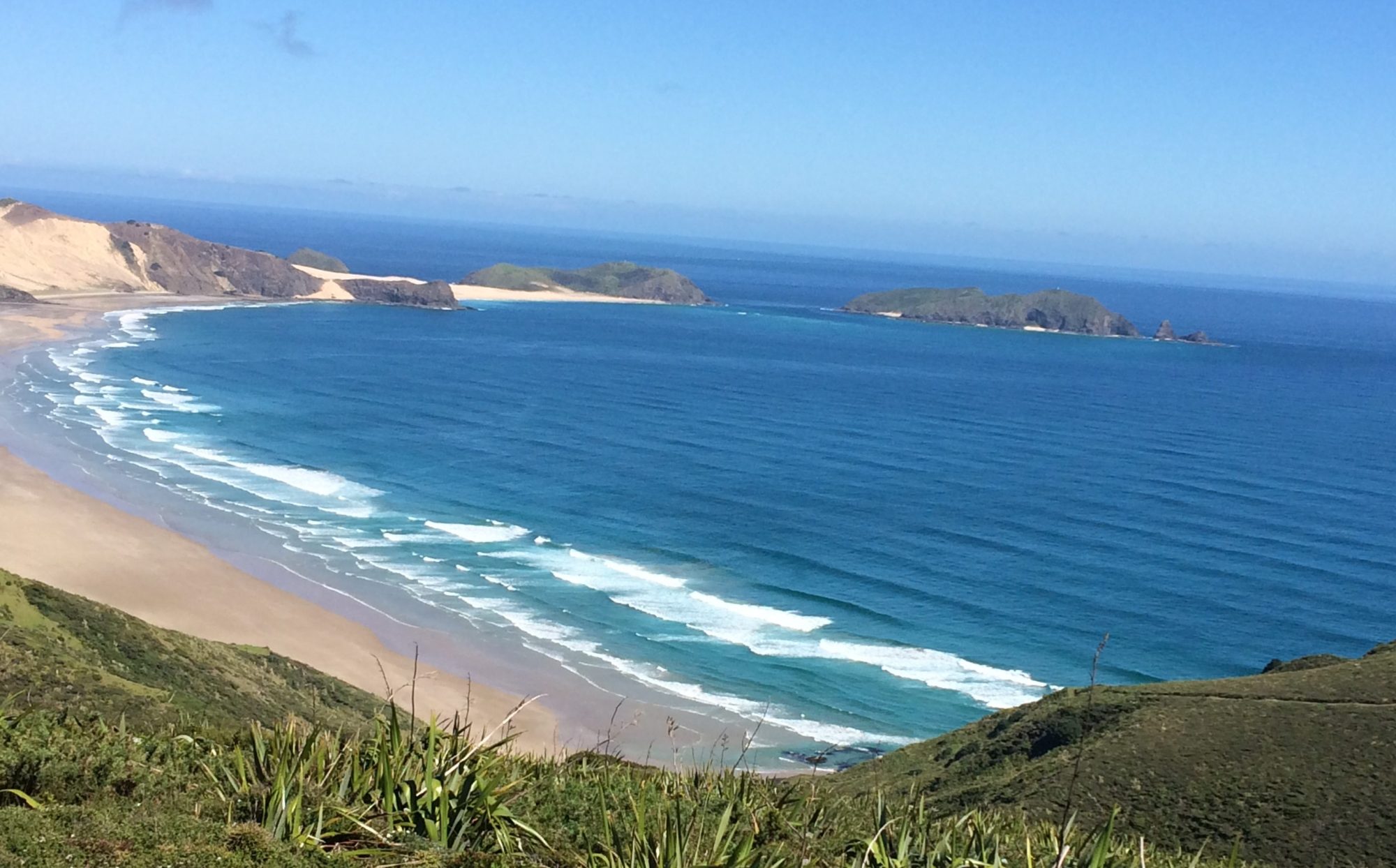
Thankfully, we find shelter on the beach behind a reefy shoreline. My TopoMap says we are at Wharanui Beach. And there is road access.
Wharanui BeachWharanui Beach(Needles Pt in the distance)
I take a moment to survey the sea state that we have just escaped. The suddenness and intensity of the breeze reminds me of the Wairarapa coast.
There is a very strong NE a couple of kilometres offshore. Between that and the shoreline there is an opposing and strong SW wind that we encountered. I don’t think I’ve ever seen anything like it. Opposing winds of such magnitude; in such close proximity. I’m glad to be on terra firma.
There are some pine trees above the beach where I can stash Secala for the night.
Secala stashed above the beach
Comfortable that Secala is well hidden within the trees; I grab the essentials and walk out about a kilometre to met Shaz on the side of State Highway 1.
Friday, 21 February Wharanui Beach to Ngaio Downs
We stayed at Kekerengu camp; 10 minutes south down SH1. Yesterdays unrealised destination.
Todays destination is Paparoa; 7 hours away and a good launch point for Kaikoura.
The forecast though, is for southerlies. Paparoa may not be achieved. Who knows where we will end up.
We drive back to Wharanui. Secala is waiting. Unmolested. We launched through a small shore break; weaved through the reefs and set off to rendezvous with Shaz at Kekerengu camp. Two hours later we reach Kekerengu and all is well.
Kekerengu Camp
SH1 remains coastal until the Clarence River delta; where is cuts inland. We set this as the next target and check-in point. 3 hours paddle away.
Dark cloud formations are looming ahead over the Seaward Kaikoura Ranges. The southerlies could be on their way. We lift the tempo with our time on the water now looking in jeopardy.
Signs of the southerly unveil slowly. Wisps and wavelets become more consistent. Then in quick order; escalating to an uncomfortable short steep sea state. With the wind ramping up just as quickly to 15kts. The dark cloud mass over the Ranges has now descended to sea level. The Clarance River delta is being consumed. And it is still 10km away. The winds preceding the front are inevitably going to get stronger. It is time to find refuge. The unprotected shoreline is 2km away. There are no reefs to dampen the shore break here. Any landing spot will be as good as another. And be close to the Highway. As we approach the shore I see Shaz and the camper pass by.
We land through the shore break and find a clump of pine trees to stash Secala. Shaz finds me on the inReach tracker and is parked not far away.
Approaching weather front
The TopoMap says we were at Ngaio Downs. A nearby farm track provides a convenient 200m walk access the where Shaz has parked.
Another day of the weather winning by TKO. But meaningful progress all the same. We head back to Kekerengu campground. This time 10 minutes north along SH1.
Saturday, 22 February Ngaio Downs to Kaikoura
An early start for a normal paddle day. Hopefully. The weather front has passed with a forecast of variable conditions this morning with Easterlies developing later in the day.
Shaz drops me back off at Ngaio Downs. There is little confidence in predicting a destination today. We plan to rendezvous at Paparoa about 4hrs into the paddle.
It is a cool morning. The front has delivered snow to the tops of the Kaikoura Ranges.
Snow on the Kaikoura Ranges
An easy launch through a low shore dump. But big enough to bury the bow and give everything a good wake up call.
Nice to see multiple pairs of Hectors dolphins this morning. But they keep their distance.
We come in close to the Clarance River delta with the Ranges providing a very picturesque backdrop.
Clarence River Delta
Emerged from the murky river water around the delta and headed straight for the contrasting steep and rocky shoreline. Where the Kaikoura Ranges kiss the coastline for the first time.
Close in to the rocky shore between Waipapa Bay and Paparoa Point we enjoy a couple of exhilarating encounters with large pods of Dusky dolphins. Factions of the pods break away and frolic around Secala. Behaving like defiant juveniles. Play-acting and diving over each other seemingly to attract attention or outdo one another.
The forecast is holding true. We say hooray to Shaz at Paparoa and made a B line across Ingles Bay to the Kaikoura Peninsula.
Good conditions remained with a strong southerly current assist across the Bay. We were making excellent progress until the Ely breeze suddenly picked up to 15kt. Then; as we closed in on the peninsula, a weather tide effect took hold. The current from the north was being forced seaward by the curvature of the Bay. And directly opposed the easterly wind.
The sea state got very messy for a while; until we got close to the Peninsula where the edge of the current lane became very obvious. From blue water to green. And the weather tide sea state subsided as we broke out of the current lane.
Shaz made contact by VHF, from the shores of Kaikoura township, to confirm our destination of South Bay.
Keen Point, Kaikoura
Upon reaching Keen Point; the settled sea state gave way to a messy bounce back aided by an escalating easterly. Eventually around Atia Point and found relief in the shelter of South Bay.
Arriving at South Bay. Shaz on the beach.
Shaz had picked out a good landing site. Good to get a full days paddle in at last. And a little tired after some unexpected testy conditions. Which is becoming a theme for us so far on this coast.
South Bay, Kaikoura
We load Secala onto the camper for the short drive to the NZMCA campground. We realise that it’s the first time this trip (since Paturau River) that we’ve had to load Secala onto the van.
Sunday, 23 February Kaikoura to Goose Bay
After much procrastination; I decided to launch into some messy Easterly conditions to Goose Bay today. Just 2 hours paddle away. It’s definitely not a day for a lengthy paddle. But figured I could grind out a couple of hours on the water. The purpose being to reduce the paddle time to Gore Bay tomorrow from 10hrs to 8hrs. Even though there are favourable conditions tomorrow; I didn’t want to take a chance on a long day where favourable conditions are unlikely to last the duration. Such has been our experience down the East Coast so far.
We paddle out of South Bay in a reasonably consistent but lumpy sea chop from the east. As soon as we reached the rocky coastline south of Peketa, the swell bounce back became annoying. We moved out deeper and around Rileys Lookout until I saw Shaz at Goose Bay. A clean landing through the shore dumpers. The rain arrives as we load everything onto the camper once again.
Goose Bay
Monday, 24 February Goose Bay to Gore Bay
A solid forecast today. Winds from the NE all day. Less likely to get caught out with southerlies. With confidence we plan to get to Gore Bay.
There is no rush from our Kaikoura NZMCA campground this morning. The edge has been taken off this paddle day by yesterday’s hop to Goose Bay.
Otumatu Rock. Spy Glass Point in the distance.
We slip easily out of the small Goose Bay dumpers and out around the Otumatu Rocks. Line up the spectacular Spy Glass Point an hour and a half away. Some pairs of Hectors dolphins show up but remain remote and peripheral.
Spy Glass Point
Spy Glass Point holds my attention. It is an attractive headland. And as we get closer, there is an alluring beach on its north side.
From Spy Glass Point the Hectors dolphins decide they want to be sociable. From a single pair they quickly multiply as 4 pairs come and go over the next couple of hours. Like children with a limited attention span; they would come and play for 20 minutes; then peel away as if bored with the entertainment. Only to return a short time later.
Conway Flat
The dominate Kaikoura Range is receding from the shoreline now. Lowland farm country of Hundalee and Conway Flat briefly occupy the coastline until the Hawkswood Range sends out its deep ravines to meet the coastline. We cruise within 100m of this interesting shoreline. The narrow beachhead is steep with shore dumpers. Not too menacing though. The NE 8-10kt conditions remain consistent. Life is easy on the water today. The distant bluff and Mt Beautiful, that mark the approaches to Gore Bay are slow in coming. The winds escalate as we enter the Bay. I spy Shaz arriving behind the dunes as we size up our approach to the beach. There are some outer breakers over some shoaling. We skirt around the edge of an outer break before catching a nice wave to the beach to finish the day off nicely.
Gore BayGore Bay
We had decided yesterday that today’s paddle would be the last for this trip. A little earlier than expected. It’s off home for some recovery and planning for what I hope will be a final trip south to complete this amazing adventure.
This stretch of coastline was always intended to be a solo trip. The outer Marlborough Sounds is largely inaccessible by road. French Pass is the only place that Secala and I will be going; that has road access. A long and winding road that we want to avoid. Shaz will meet me on the other side of the Sounds. Probably Whites Bay AGW. This will be the longest solo trip and the heaviest Secala has been since Fiordland.
The following days paddle from Whites Bay to Marfell Beach concluded this section
Saturday 8 February, 2025 Cable Bay to Otuhaereroa Island (Croisilles Harbour)
Planned a short day today; in anticipation of arriving at French Pass at the top of the flood tidal stream tomorrow. Due to strong southerlies forecast through Cooks Strait and Cape Jackson next week; I figured that French Pass campground would be a good place to wait and pounce on Cape Jackson, when the forecast came right.
I also expect that the French Pass campground would likely be full for the long Waitangi weekend. So splitting this trip to French Pass into two days made some sense.
As for today; we aim to be somewhere around the Islands at the entrance to Croisilles Harbour. About half way to French Pass. I have identified a beach just behind Kakaho Point. But there would likely be many camping options in the area. And we will have plenty of time to explore.
And so; a casual start today. We pack up the camper at the Cable Bay campsite and drive 200m to the rocky shoreline. We pull Secala to the waters edge and load her up. Shaz has got me some more freeze dried Real Meals from Nelson. My new favourite.
Loading up at Cable Bay
It’s a glassy sea surface. We should enjoy rock hopping our way towards Cape Soucis and the Islands of Croisilles Harbour.
Weaving through rocks off Pepin IslandŌananga Bay looks a likely place to exploreŌananga Bay towards Cape Soucis
Four cruisey hours later we weave through the rocks and reefs of The Islands at the entrance to Croisilles Harbour. What a contrast from the West Coast.
Approaching Cape SoucisThrough the reefs on north side of Motuanauru IslandNorth side of Otuhaereroa IslandNorth side of Otuhaereroa Island; Kakaho Point ahead.Inside Kakaho Point
We tucked into a rocky beach just behind Kakaho Point. Unfortunately soon after settling in; the angry farmer “owner” came along on his boat and aggressively objected with me being there. And was not open for a sensible discussion.
It was still early in the day; so we relocated camp to the nearby Otuhaereroa Island. Apart from that episode; it was a very enjoyable morning on the water. And an angry little twat wasn’t going to spoil it.
A wonderful evening in a most beautiful location. With no sandflies. And very good cell service to check weather forecasts.
Camp on south side of Otuharereroa Island. Kakaho Point (mid right). D’Urville Island (background)
Sunday 9 February, 2025 Otuhaereroa Island (Croisilles Harbour)to French Pass
There is much anticipation of the transit through French Pass today.
It is probably the most infamous navigable tidal channel in NZ. Along with French Pass today; we will be transiting the tidal streams at Cape Jackson and Tory Channel in the next few days.
For a kayak, utilising slack tide in these areas is the only sensible option. Particularly for the first time.
Todays flood (NE) stream through French Pass is predicted to start at 0629hrs; and the ebb (SW) stream at 1144hrs. My plan is to catch the slack at the top of the flood. Before the opposing ebb stream gains momentum.
We are up and on the water at 0640hrs. It’s only 3.5 hours to French Pass, so we will arrive early. I hear there is a beach on the south side of the Pass. Where we can pass some time and hopefully observe the tidal race.
It’s a beautiful clear morning. As we clear the Islands a NW crosswind whips up to 15 knots. Earlier than expected. The paddling is on the slow side until Okuri Point; when the flood stream assist starts to take effect. We cross Waikawa Bay and into the Current Basin. The crosswind subsides in the lee of D’Urville Island; and the flood stream takes hold. We reach 8km/hr without much effort.
It’s only 0930; we’re 3km away from the Pass and can hear the roar of the tidal race already. The flood will be in full flight now. And it sounds intimidating.
I’ve not been to French Pass before. But I know its reputation as a treacherous stretch of water from my maritime background. We cautiously approach on the south side of the Pass. Looking for the beach.
Half an hour later we can clearly see the impact of the convergence. We approach on the southern edge of the tidal flow where the beach becomes apparent. There is a small rocky nook closer to the edge of the tidal race. We tuck in there hoping for a better view of the Pass. But there isn’t. So we take refuge on the beach. I can see the outer edge of the tidal race as it constricts towards the gap. It wasn’t an ideal view. But should be good enough to see a slackening of the tidal race at its outer extremity. (I realise later that there is a short track up from the beach that will lead to the Lookout track for a much better view of French Pass)
Beach on southeast side of French Pass. Waiting for tidal stream to ease.The outer edge of the tidal race can be seen behind the rock at the Point
We wait for an hour and a half. Three other kayakers approach from the south. They tuck into the same rocky nook that we did. And out of view.
The flood stream is definitely diminishing now. And the predicted time for the ebb stream had arrived. We launch to get a better view around the point. The three kayakers had left the rocky nook and must have gone through the Pass already.
Even though the narrowest point of the Pass is still obscured; the tidal flow has waned significantly in the last 15 minutes. The slack can’t be too far away. We commit to the last of the flood stream. The transit is swift in pace and duration. Within touching range of the rocky shoreline it took 4 adrenaline filled minutes to get through the Pass. We swung out of the main flow just on the north side of the Channel Point lighthouse. Much quicker than expected. My GPS clocked 9km/hr without much paddle assist. It turns out to be a bit of an anti-climax really. Which is a relief.
Ten minutes later we swing around Collinet Point to the beautiful vista of Elmslie Bay.
And land on the calm, golden beach under the French Pass campsite.
French Pass
The campground above the beach is still evacuating after the long weekend. It is only midday. I found a quiet corner to pitch my tent. We could be here for a few days. The strong southerlies are still predicted at Cape Jackson.
Bumped into Bevan Walker (we met at the Landing Shed at Puysegur) who had just completed a paddle around D’urville Is. And was one of the three kayakers who had just come through the Pass.
We spent a very relaxing 3 days at French Pass. There’s usually something going on to take your interest. A small vehicle ferry runs frequently out of Elmslie Bay to D’Urville Island. And the boat ramp is often in use. Just beside the campground, visitors are attracted by the three resident stingrays that constantly patrol within a meter of the shoreline.
I walk up the road a couple of times a day to just sit and watch the tidal stream. Often boats; usually under-powered yachts; struggle against the tidal flow. With some having to abort and turn back around. I have found a spot on the hills behind the campground where there is acceptable 3G cell reception. Where I can check weather forecasts. And contact Shaz. Who is having water pump issues in the camper van. I’m gutted to have left my fishing line behind, with so much time on my hands. The Cape Jackson forecast stays true for the next few days. 30 knot southerlies. It’s fine at French Pass though. The biggest problem I have are the cheeky wekas. They steal anything with a scent to it. From soap; toothpaste and coffee. Even unopened freeze dried meals. And they have no qualms in entering your tent. I resort to hanging as much gear as possible in the trees. We intend staying in French Pass until there are two consecutive paddle days available. The key reason is the lack of water. This area of the Sounds is largely open dry stock farmland. The land is parched and crunches underfoot. There is little prospect of replenishing my 2 day supply of water until we reach Queen Charlotte Sound.
Vehicle ferry to D’Urville IslandElmslie BayThe Pass at the top of the floodLooking south from above French Pass. D’Urville Island on the right.Cape Soucis far distance on the left.
Thursday 13 February, 2025 French Pass to Alligator Head
In similar fashion to the approach to French Pass; I plan to set up the rounding of Cape Jackson with the HW slack at 1100hrs tomorrow. In this case though; the ebb (SE) stream will be in our favour; so being late for the slack won’t be so crucial. But not too late. We are in the middle of spring tides now.
In easy conditions we round Clay Point, Paparoa and Culdaff Points to the south side of Alligator Head. We stop at a couple of likely camping options along the way. But continue to a beaut spot on the south side of Alligator Head.
Rounding Clay Point (right). Paparoa Point (centre). Alligator Head in the far distance.The sunny eastern side of Clay PointCuldaff Point. Alligator Head (ahead). Titi Island (left)Checking out a spot on Alligator Head. Culdaff Point behind.Beach on south side of Alligator Head
As anticipated; there is no water. The area is totally parched. I make a point of using my primus well down the beach; in the wet tidal zone.
Looking out into Guards BayTypical dry terrain. No water around here.
Friday 14 February, 2025 Alligator Head to Blumine Island
Up a 0500. It’s going to be a longer paddle day but no reason for an early start. We have to wait till 1100hrs for the slack at Cape Jackson. And it’s less than 3 hours paddle away. There are no tidal stream predictions for Cape Jackson. So I’m assuming a conventional time for slack water. Close to the predicted HW. If I’m late for the HW slack; it’s OK. The ebb stream runs in my direction (SE) around the Cape. Preferably catch the ebb as early as possible. With assumptions and unknown territory; I buy time and launch early. The forecast is for light winds towards Cape Jackson today; with a light SE’ly on the east side of the Cape. This will create a weather tide scenario; so hoping they aren’t going to be too strong. Fabulous clear morning. Rounded Alligator Head and headed straight into the sun. That is annoyingly on the horizon. Had to keep my head down for about an hour.
Alligator HeadBeach on north side of Alligator Head
On the northern tip of Alligator Head I see to beaut beach that looks to be an excellent camping alternative. It would be exposed to the north but is ideally located between French Pass and Cape Jackson.
The only feature of note towards Cape Jackson; is Cape Lambert. There is all sorts of shoaling and upwelling in this area to keep your interest up.
An hour and a half into the paddle now, and I can comfortably look straight ahead again. We are going to be very early for the slack tide; so loosely aim for Onehunga Point; on the inside (west) of Cape Jackson to try and find the cove/hut that I have heard about.
About 4km away from Onehunga Point I see ahead that the sea surface is whipped up across Port Gore into a broad area of white caps. Stretching from deep inside Port Gore, out to the Cape. From a distance, on flat calm sea; I wondered if it could be a tidal race over a shoaling area. I bloody well hope not. A little closer and it’s clear that this is actually a localised wind squall of some intensity. It seems to be funnelling over from Endeavour Inlet. The rest of Port Gore is calm.
Approaching the inlet with track up the hill.
We’re close enough to the shoreline now, to make out what I think is a track down a hillside to a possible cove. Onehunga Cove. Hoping to find refuge here; I put my head down and commit to crossing the squally turbulent area. I don’t apply enough leeway; and we get pushed seaward towards the Cape. Continued paddling hard to the shoreline to find some sort of cover from the wind. And then had to regain 300m of lost ground to discover the remarkably quaint Onehunga Cove. Landing options at this state of tide (2 hours from HW) is limited to some rocks in the south corner of the cove. There is a sandy bottom where a small tidal beach would be exposed at LW.
Onehunga Cove with Cape Lambert in the distanceSecala pulled up on rocks at high tide
I drag Secala up onto the rocks. Far enough to be safe from two further hours of flood tide. I hope. In knee deep water, I wade around the cliffy shoreline to the bottom of the track. It weaves up to a hut with a magnificent view across Port Gore. And a very convenient flush toilet. The hut is locked and doesn’t appear to have been used in some time.
Hut on the hill (with flush toilet). Port Gore and Cape Lambert beyond.The track continues up to the ridge where you can view Queen Charlotte Sound
Typically; now that we have crossed the Bay; I see that Port Gore is restored to calm. The squall zone has disappeared.
View west from ridge
With time on my hands, I follow the track up the hill to view relative calm on the Queen Charlotte side of Cape Jackson.
When I returned to the cove, a seal is sunning itself on the rocks at the bottom of the track. Blocking my access to Secala. With a little encouragement he’s back in the water.
To my surprise I discover a wet patch on the rocks at the bottom of the track. A trickle of water is emerging from the mossy undergrowth. It looks a little murky; but tastes fine. I replenished my empty water bladders.
HW wasn’t far off now. I jumped in Secala and chatted with some recreational divers on “Empty Wallet” just outside the cove. They say the slack has arrived early today. The ebb has already started. The Cape is only 10 minutes paddle away. Knowing that it was a spring tide; we made haste to catch the early ebb stream. Again; with some anticipation, in unfamiliar territory, we commit to the gathering flow. Glancing seaward I see Cape Jackson and Walker Rock shoaling areas have established a solid ebb stream over them. We have missed the slack; but not by too much I hope.
We stay close to the rocky shoreline slicing through small overfalls around the rocks at the tip of the Cape. Like French Pass; we were through and out the other side in less than 5 minutes.
Made the radical right turn on the knife edge of the Cape and immediately got hit by a niggly weather tide with a 12kt SE coming down Queen Charlotte Sound. A fisherman on “No Promises” diverts towards me to see if we were OK in the “choppy” conditions. We stay close to the shoreline where conditions are better. Two hours later we pull into Ships Cove for a visit and a rest. And to dwell on a successful day so far.
Ships Cove – Captain Cook monumentShips Cove with Motuara Island (middle)
There is a clean flowing stream here. I read on the Captain Cook monument that he had visited here 5 times. Amongst other things; to find shelter and replenish water on the Endeavour. Figured I would do the same; replacing the murky Onehunga Cove water. I will now be fine for water for tomorrow (Tory Channel) and beyond to Whites Bay AGW.
I jump back in Secala for the 1.5hr paddle through relatively congested waters to Blumine Island campground.
Approaching Blumine Island
It’s been a wonderful day. Good to get a full day on the water for a change. And some reasonable miles under the belt. With a couple of very interesting shore excursions.
Blumine Island camp is relatively quiet with only two other kayakers staying the night. There is still time in the day to solar charge my inReach and battery bank. And take a walk along the island track to find some cell reception.
Saturday 15 February, 2025 Blumine Islandto Fishermans Bay
Another setup day. A short hop to a camp inside Tory Channel entrance. And wait for the slack tide about midday tomorrow. The same strategy and the same slack used for Cape Jackson.
We remain at Blumine campground until 1000hrs to catch the ebb flow through the Sounds. May as well make life easier when you have time to kill. The only concern today could be the moderate northerlies that were forecast. They could present an issue through Tory Channel.
For the first couple of hours it was like a magic carpet ride with a slight Nly breeze at my back and floating on the current. Rounded the SW corner of Arapaoa Island into Tory Channel.
Rounding Ruaomoko Pointinto Tory Channel
Hugging the shoreline I can see by the telltale seaweed that we had timed the ebb tide perfectly. Occasionally the topography generates a few strong back eddies. And the northerly headwinds are squally in places. Otherwise an easy and very enjoyable paddle.
Snack time near Wiriwaka PointSalmon farm near Ngāmahau Bay
The kayakers at Blumine Island suggested that the old whaling station down Tory Channel would be a good camping option. Our intended destination though, is Okukari Bay – the last bay before the Tory Channel entrance. As we pass by Fishermans Bay with its whaling station I see a good camping option. And is also very close to the Tory Channel Entrance.
White Rocks (Tory Channel behind)
We continue towards Wheki Rock and the entrance to Okukari Bay. There is a solid tidal race occurring from Wheki Rock and over a broad area at the entrance to Ōkukari Bay. It was mid tide and the ebb stream would be at its strongest.
We backed up to the much more tranquil Fishermans Bay. Where we will make camp. A cruisey afternoon spent watching the coming and goings through Tory Channel. And boaties moored at the old Perano whaling station wharf.
The bonus is that it has long drop. And even though there are no wekas; I take all precautions with the gear.
Fishermans Bay (Perano Whaling Station)Great camp (with weka precautions)Tory Channel. West Head lighthouse (top right)
Sunday 16 February, 2025 Fishermans Bay to Whites Bay
Another casual start today. With a difference.
Like the previous tidal stream transits at French Pass and Cape Jackson; the Tory Channel HW slack will be around 1130hrs.
Unlike the other tidal stream transits; Tory Channel is only 1.5km (15 minute paddle) from Fishermans Bay. We don’t need to launch until around 1100hrs.
The Cooks Strait coastline south from Tory Channel is remote and rugged. Refuge areas are scarce. The forecast is for a light NE today should be ideal to easily push us through to Whites Bay.
Eventually 1100hrs arrives. The view through to Cooks Strait still looks calm. We make our way across to the Channel; sizing up the tidal stream along the way. There is no significant flow. In either direction. So far; so good. Within 15 minutes we’re paddling below West Head. Observing the seaweed beneath; a slight ebb flow is evident. Perfect. We couldn’t have timed the slack through the Tory entrance any better.
(Contradicting its name; West Head happens to be the easternmost point of the South Island mainland.)
Within minutes we are through the entrance. There is a light (8-10kt) NE wind and low NE swell. Combined with a southerly ebb tide; it feels like riding a magic carpet. All conditions are in our favour. Days like this don’t come often.
As expected the coastline is rugged and inhospitable. Definitely not a place to be caught in adverse weather. Or difficult weather tides.
Approaching Jordy Rocks
We approach Jordy Rocks and encounter one of the great moments for any kayaker. Up ahead a very large dorsal fin emerges through the sea surface. And keeps rising. The dorsal seems impossibly long. Under its own weight the top third curls over. Like a developing wave that eventually succumbs to gravity.
It’s a heart stopping moment. Being so close to such an immense creature that has such beauty and grace. I haven’t been so consumed by the presence of such an elegant creature since our encounters with the albatross off Fiordland. This time tinged with a daunting sense of vulnerability and helplessness. The heart recovers and is elevated. More in magnitude, than rate. Like a slow beating drum.
The huge dorsal is 50 meters ahead; slightly on our right hand side. And closing fast. With a wider lens, I realise that there is actually a pod of orca. Two large adults with a few juveniles.
Not surprisingly, the pod slides down our starboard side giving no indication that they are aware of our presence.
The moment is over too soon. I reluctantly reach for the paddle to resume the journey. To take stock of the surroundings. And directly ahead is another pod of orca. Another large dorsal fin is directly ahead. Right over Secala’s bow. And heading my way. It will only be moments before the gap is closed and this huge creature will be within touching distance. Like the earlier pod; dorsal fins of various sizes come into view. Porpoising towards us.
We veer slightly to starboard. To give them (and me) a little space. Even accidental contact would be something to avoid.
It’s another pod of similar size. Two adults with juveniles. Seemingly family pods travelling together.
They pass very close down my port side. At close quarters; their size and effortless motion are a contradiction. Once again; we are awe struck and totally ignored.
Blessed to have had these rare moments. That are unlikely to be replicated.
I gather up the paddle and reluctantly focus ahead. The magic carpet ride resumes.
At Lucky Point we experience a very strong lateral current that shunts us sideways out of the bay. The curving topography of the bay forces the current through its arc and projects the body of water seaward. The magnitude of the lateral drift is fully appreciated by observing the speed of transit of the landscape; beyond the nearby rocks of the Point. I’ve never observed such swift lateral movement before. It was like sitting sideways on a roller coaster.
Lucky Point
Before long we pass Glasgow and Fighting Bays. We tuck inside Coombe Rocks for a look. There looks to be a reasonable gap to paddle through. And it’s mid ebb tide. There is just enough water to weave through the rocky gap. Doubt that this would be passible at low tide.
Coombe Rocks
Rarangi and the entrance to Whites Bay is just over an hours paddle away. Across the entrance to Port Underwood.
We turn into Whites Bay; and right on queue, Shaz makes contact on VHF. And directs us ashore on a shallow sloping beach. This concludes an eventful nine day solo trip through the Marlborough Sounds. Six paddle days and 3 weather days at French Pass. And three significant tidal streams. It’s been a magnificent trip through the Sounds. And there is so much more to explore.
There’s a temptation to have a break after a solo stretch. The forecast this morning is too good though. Moderate to strong easterlies are due this afternoon that we need to beat. Even with an early launch; and there is still the prospect of being caught by the early arrival of the headwinds. I discuss with Shaz the possibility of coming ashore prematurely. Maybe along Cifford Bay; if necessary. There is shoreline access at Flemings Road and Cable Station Road. Shaz will keep an eye on our progress.
So an early start it is. Most of the day will be a little offshore. Transiting Cloudy Bay to White Bluffs. Then across Clifford Bay to Marfell Beach.
White Bluffs
The prominent White Bluffs are my first target. An early offshore SW builds out of the Wairau Valley soon after we leave Whites Bay. Up to 15 knots. We have a nice transit line behind White Bluff to Cape Cambell to gauge leeway. We are lightship today and it’s soon apparent that some leeway needs to be applied.
The offshore dissipates as we find the shadow of White Bluffs. They are sheer with little opportunity to land. And breakers extend way offshore in places.
Marfell Beach is difficult to identify as we enter Clifford Bay; despite being reasonably familiar with the area. I approximate a point inside Cape Cambell. Which will be close enough. Four hours into the paddle and the forecast easterly arrives. It’s more north of east so sits nicely on the port beam for now.
Marfell beach eventually becomes obvious with the motorhomes lining the shore. Shaz is having the water pump replaced in Blenheim when we arrive. We land just below the campground. It’s “conveniently” low tide on a shallow sloping beach. Secala and I get up the beach to claim a campsite and wait for Shaz’s arrival.
Marfell Beach with Mussel Point (top left)
It’s been one of those ho-hum paddles. With White Bluffs the only point of interest. It’s also been a little slower than normal with a northerly tidal flow most of the day.
Marfell campgroundLooking back across Clifford Bay to White Bluffs and Cooks Strait
The top of the South Island is complete. What a contrast to the West Coast. That’s the beauty of kayaking on our dynamic coastline. Now for the South Island’s east coast. With it’s own set of challenges.
A year later; we are back. And keen to finish off the West Coast. A nagging hangover from last year. Then ……. some solid progress down the East Coast. Hopefully. There are some hurdles to overcome though. Some of the most remote and rugged coastline in the country. And Farewell Spit.
But first – Kohaihai Bluff ………..
Tuesday 21 January, 2025 Kohaihai Bluff to Seal Bay
We made haste from New Plymouth to Kohaihai. The immediate swell forecast looks good. Required for a Kohaihai launch. With it’s fearsome reputation.
You also need a good 2-3 day forecast. This NW section of the South Island is rugged and remote. There are few known refuges. Few paddlers have taken it on. And those that have; have stories to tell.
At the completion of our trip here last year we identified a better launch location 2km south of the Kohaihai campground. The beach was not as steep. The shore dumpers were not as menacing.
The swell forecast now is 1.5m reducing to 1.2m. You can’t expect better than that around here. We parked at the Mossy Burn bridge lay-by to reaquaint ourselves with the conditions. At an equivalent state of tide that we would have tomorrow morning. It would be an ebbing mid-tide.
There is a nice “hollow” just beyond the shore break. Very handy. A place to dwell before taking on the destructive outer break.
But that is not all. There is a second outer break to contend with. Which becomes more prominent as the ebb recedes below mid-tide.
On the positive side; the shore dumpers should moderate as the tide backs away from the steeper section of beach. An ebbing mid-tide was shaping up to be a good launch period. As good as any.
Down the dunes and across Mossy BurnMossy Burn bridge and lay-by
There are two good paddle days left in this weather window. After that all bets are off.
Weather would dictate progress; ….. as always. With two days I should reach the accessible haven of Paturau River. There is a campground there. And Shaz can drive there via a 30km gravel road if needed.
Ideally though, we are planning to get to Fossil Point (Farewell Spit) on the third day; bypassing Paturau River altogether. This plan will have two remote overnight camps. At Seal Bay and a beach just south of Whanganui Inlet. I have no paddle intel on either. They are unknown as paddle destinations. I identify them both as possible landings while inching my way along the Google Earth coastline. They look great on paper. But who knows what we will be confronted with when we arrive. Or what the suitable alternative would be if they weren’t.
Seal Bay (Google Earth)2km south of Whanganui Inlet (Google Earth)
I have packed Secala with several days worth of supplies. In case plans change. And we need to take refuge somewhere on this remote and rugged coast. Which is probable.
Today’s target though is Seal Bay; 7km south of Kahurangi Point. And conveniently midway between Kohaihai and Whanganui Inlet. About 6 hours paddle. I prefer to restrict my first few paddle days to about 6 hours. To bank some paddle fitness early; for the bigger efforts to come.
I was confident of getting out of Kohaihai today. They were my first impressions of the conditions. We have launched in harsher shore breaks before. But it wasn’t going to be easy.
The launch attempts turned out ugly. Uglier than they should have been. And took four attempts.
Paddlers familiar with heavy shore breaks know that selecting the setup location on a sloping beach is usually a key to success. There is an element of luck; with waves of varying intensity. Sometimes sweeping past you; sometime short. Additionally; Secala is well loaded and harder to manage. Once in the cockpit, a few seconds are required to secure the skirt and grab the paddle. And a few seconds is often all you have.
I get the first two launch attempts all wrong. I have set up too close to the sweeping shore break. Twice we get sucked into the maelstrom before we are fully prepared. We get smashed back on the beach before leaving it. It’s frustrating, tiring and time consuming.
Mid-tide conditions
On the third attempt, we get things right. And we’re through the shore break. We sit in the “hollow” behind it. And take the first gap that I see in the outer break. And get the timing wrong. There wasn’t a gap at all. And I have committed too far. Successive waves rear up in front of us. We rise up the first one as the crest was breaking. My chest and head get smashed backwards by a solid green wall of water as the heavy Secala ploughs through and over.
This momentary feeling of relief is dashed; as we flop over the crest, and gape at a second larger wave. Crestfallen; we take on the challenge. Despite knowing the outcome. The wave is already breaking heavily and will swamp us.
Like a defiant child; we paddle hard into the maelstrom ……. to be consumed and eventually spat out like a piece of driftwood.
More frustration. And more energy sapping time lost. We start over again.
Our forth attempt is pretty much perfect. And should have been what the first attempt looked like. Maybe. If I had shown a little more patience.
We are through the shore break again. More time in the hollow. A full swell set rolls through. We sprint out the lull without a problem.
Almost two hours are wasted. And I nearly lost my drybag of tent poles that somehow became unclipped from behind the seat. And recovered where they had washed up 30m along the beach.
The first major obstacle has been overcome. Beyond the surf breaks, the conditions are perfect. A paddle wave to Shaz and the adventure is finally underway.
Kohaihai Bluff
Passing Kohaihai Bluff and Scotts Beach; pods of Hectors dolphins momentarily drop by. Enough to sooth the mood and easing the pulse.
The Heaphy River arrives quickly. The pounding shore break continues unabated. Reminding us that these fully exposed ocean beaches of North Westland offer few safe havens.
We settle into our paddle rhythm on this spectacular coastline. The sea conditions couldn’t be better.
Four hours from Kohaihai, we close in on the prominent Wekakura Point. Large rocks extend directly off the beach that would offer good protection from northerly or southerly conditions.
Wekakura Point
Rounding Steep Point; Big Bay beach looks enticing in these benign conditions. Rocks Point at the northern end of Big Bay offers more dramatic shoreline to navigate.
Around Rocks Point and the outcrop of Seal Bay becomes obvious. As we get closer I could see right through the sandy gap that seems to form an isthmus between the mainland and its promontory. Offering two potential approaches and landings at Seal Bay. One from south; or go around the rocks to approach from the north. I chose the northern approach. Much of the northern beach is exposed to the swell. More so than the southern approach. But we hug the rocks of the promontory and find a sheltered landing in its lee.
I am stoked. This placed has turned out so much better than I could have imagined. Remote; idyllic; beautiful. And all mine. There is no sign of recent human occupation.
Seal BaySeal Bay. Landed in the lee of the rocks.
I check out the entire beach. There are rocks that divide the beach in half. The eastern side is much more exposed to the westerly swell. And there’s a decent shore break. It has the only good water source with a steady stream of water tumbling from the rocky undergrowth.
The western end of the beach has an isthmus that offers a sheltered landing from both (north and south) directions. And a better camping option for protection from the west and south.
Camped on the beach. Mine are the only footprintsin the Bay.
There is no sign of previous human activity. It feels like my very own discovery. Without doubt, one of my favourite locations so far on this entire NZ circumnavigation. And better still; there are no sign of sandflies ….. yet.
I take the opportunity to strip off for a swim and wash off the Kohaihai sand that’s got under the wetsuit. There is plenty of time to get re-acquainted with the old camp routines. And soak up the surroundings. I set about solar charging the battery bank; replenishing water; fresh water rinsing and drying the gear. Erecting the tent. Soaking up this stunning area and its wildlife. As the day wanes, a few sandflies do turn up. Not enough to be annoying; but enough to suggest that they probably have more friends nearby.
I can be very content with the day. It’s been a long one. Dusk arrives as weariness set it. Kohaihai is behind us. No mean feat. It was a beautiful paddle on a most stunning coastline. And concluded with a camp on a remote piece of paradise. What will tomorrow bring!
Wednesday 22 January, 2025 Seal Bay to Paturau River
Todays paddle destination is still undecided. It depends on tomorrow (Thursdays) forecast. It had been showing strengthening SW on Thursday; up to 30kts at Cape Farewell after midday.
My planned destination is another “Goggle Earth” discovery; 2km south of Whanganui Inlet. Similar to Seal Bay; offering a protected landing in the lee of a rocky shoreline.
This would be a 7.5hr paddle from Seal Bay. From there its only 4hrs to get around Cape Farewell on Thursday. If I could get around Cape Farewell by midday; I might beat the strong SW’lys.
Plan B is to come out at Paturau River. A shorter 6hr paddle. Where Shaz can drive to. And we can camp until the conditions improve.
Shaz is primed to send me an extensive forecast for Thursday via inReach overnight. I will make the decision on paddle destination in the morning. Whanganui Inlet (south) or Paturau River.
I rise at my usual 0430hrs. A good sleep considering. But a few aches and pains from yesterday’s hiding at Kohaihai. To be expected.
Soaked my breakfast cereal, made a coffee and read Shaz’s lengthy weather forecast. Which hasn’t got any better. Cape Farewell actually looks worse. Decided to make Paturau River the destination and told Shaz I would be on the water by 0700. No rush. Today’s forecast is good. And I only have a 6hr paddle instead on 7.5hrs. Shaz will have a bigger day than expected. With a long drive from Motueka with a 30km gravel road from Pakawau to Paturau River campground.
A very reluctant departure from Seal Bay. If there is ever a place to return to; it is here. Or be weather bound for a couple of days. But this is the West Coast. When there is a good paddle day; you take it every time.
It’s an easy launch. Within seconds we around the protective rocks and beyond the surf zone. What a contrast from yesterday.
Kahurangi Point soon comes into view. The lighthouse structure is much more majestic than expected. I was expecting something insignificant. Like Puyseguer Point or West Cape.
Kahurangi Point
The rest of the paddle is very enjoyable keeping as close to the shoreline as practicable; considering the numerous offshore reefs. Once we venture a little too close to shore and scrambled to meet a very large wave as it rose menacingly towards us. With its death rattle in progress. A few heart pumping seconds of hard paddling and we flop over the peak.
Anatori River campground
Paturau River eventually arrives. A little slower than expected; with the last 3hrs against light headwinds.
I see the top of the camper moving behind the dunes. Shaz has arrived and is soon at the top of the beach sizing up the best landing spot.
Paturau River
There are reefs to the south of the river mouth. Evidenced by rocks awash in the tide zone. The surf zone looks similar whatever approach we take. Continuous lines of tumbling surf. But nothing too menacing. We enter and ride the surf with a little too much complacency. And get flipped in the shallows. Unnecessary and annoying. But Shaz enjoys a good laugh. Nevertheless; another enjoyable day of solid progress on this wonderful coastline.
23 – 29 January, 2025.Paturau River
We are expecting to spend some weather days at Paturau. But the “weather days” have developed into a westerly storm. We decide to seek shelter back at the NZMCA park in Golden Bay.
Before we leave Paturau; Peter Hall introduces himself. The owner of the land around here, including the campsite. He stays in a caravan while renting out a couple of houses behind the campground. He’s impressed with our story.
On the 27 January we returned to Paturau to find heavy surf and strong SW winds. Conditions are forecast to ease over the next few days. The familiar waiting game on the West Coast continues. Twice daily I walk 1.5km back up the road to get cell reception. And the latest forecast.
Paturau River camp down the riverPaturau campgroundPaturau River Bar
Finally, on the 29 January the swell conditions look good enough. And the NW winds are forecast to ease. We prepare for an early launch tomorrow.
Thursday 30 January, 2025 Paturau River to Fossil Point
All set for an early launch this morning. The forecast swell conditions are set to rise through the day. Paturau has a deceptive surf given any swell and tidal combination. The view from the top of the beach offer no glues for a preferable exit. The surf lines are continuous over the reef. But look relatively benign. And yet at sea level; in the kayak, they feel quite daunting. As we were about to find out.
A quick walk up to road to check the forecast. It hasn’t changed. The forecast swell is rising today from 1.6m to 2.0m. Providing some incentive for an early start. The tide has turned and the flood begun. We are set to launch at 0630. Although Shaz is apprehensive about my chances.
We launch behind the fully exposed rocks below the campground. The unrelenting stream of tumbling surf offers few glues for timing a breakout. It’s energy sapping and we’re getting nowhere. I become impatient and pay the price. The washing machine spin cycle picks me up and spits me out.
Peter Hall comes running down the beach from where he was watching on the hill. He offered some advise on the better launch spot some 200m along the beach. He describes a gap in the reef. Good to have that local knowledge. And an alternate option. But I suggest to him that I would give it another shot when the tide has had a bit more time to flood. Which will cover the reef a little more and take the heat out of the outer breaks. Hopefully. We head back to the camper for a cup of tea.
Waiting around isn’t a strength I possess. I’m itching to give it another attempt. Shaz says I’m crazy. And asks me for the passwords to my bank accounts.
The surf hasn’t perceptively changed. But giving it another go; we must. I figure conditions aren’t going to improve anytime soon.
This time success. Maybe I’m a little more patient. More likely a little more lucky. Whatever the case ………..we are out of Paturau River. And perhaps the last “real” West Coast launch. Shaz expresses disbelief on VHF. A paddle wave and we’re off.
Great to be on the move again after a week confined to barracks. The target today Fossil Point at the base of Farewell Spit.
The wind forecast is for essentially light winds through the day. There is a blanket of altostratus overhead; stretching to the northern and western horizon. There is a clear line of precipitation and reduced visibility ahead. The sea is a little lumpy. Probably a relic of yesterday’s strong onshore NW winds. We pass the conspicuous Sharks Head that looks like an inverted sharks head with open jaws. Soon after that the outer breakers of the Whanganui Inlet become conspicuous. We drift out wide. It is the top of the tide now. We have made good progress through the flood. The turn of the tide will gather against us soon.
As we head north of Kaihoka Point the weather closes in. Rain showers are heavy; impairing visibility. The wind remains a steady 10kt from the west. For now. I am a little apprehensive that the weather may change; or amplify, as we close in on Cape Farewell. As they tend to do at all geographical extremities. I consider our refuge options. There is Wharariki Beach at the Archway Islands. But nothing much else. The coastline is rugged. Limestone cliffs grow in prominence to culminate at Cape Farewell. If we choose not to pull out at Wharariki Beach; Fossil Point is the only viable alternative. And only another hours paddle away.
The Archway Islands are much larger and imposing than expected. Yet provide some finesse and beauty to a dramatic and daunting shoreline. Caves in the cliffs have been carved out by the ocean. Booming emanates from them as the sets roll through. Adding to the drama of the spectacular landscape.
The sea conditions become much more sloppy as the bounce back opposes the sea state. I can also feel the strength of the ebb tide gathering against us now.
As we round the Archway Islands; Farewell Spit comes into view. The conditions are holding. And the decision is made. Fossil Point will be the destination. We round Pillar Point and line up the beach just to the east of the reef at Fossil Point. And ride a gentle surf onto the beach.
It has taken longer than expected to get here from Kohaihai. We have only paddled 3 days out of the last 10. Below par. But the successful completion of the formidable NW coastline cannot be snivelled at.
It’s time now to focus on the next challenge. The rounding of Farewell Spit.
Fossil Point (with Pillar Point in the background)
I stash Secala in the dunes and take the 20 minute walk out to Shaz at the car park.
31 January – 02 February Fossil Point(Pakawau)
Getting the conditions right for the Farewell Spit paddle will be important. It’s a big day even when they are favourable. We bide time at Pakawau. While Secala rests up in the dunes.
Secala in the dunes (Fossil Point and Pillar Point to the west)Looking east down Farewell SpitFossil Point
Keeping active in the down time.
Monday 03 February, 2025 Fossil Point to Mutton Cove
I have looked forward with anticipation to this paddle. For a long time. Symbolically closes the chapter on the South Island west coast. Significant enough in itself.
The Spit has a mystique. An aura accentuated by its remoteness and access prohibition. On a global scale; it’s huge. 35km long. It’s a wildlife sanctuary and a place of regular pilot whale strandings.
Each side of the sand spit endure completely different marine conditions. The northern side contends with the harsh open ocean. While Golden Bay enjoys the buffer and relative tranquility. It is well known in the maritime world as a sanctuary for vessels; a safe haven from adverse weather.
My curiosity with this place is intense. What does the interface look like as the Spit delves below the sea surface? And the tranquil Bay clashes with the open sea. How big will the breakers be? How does the tidal range impact the observable length of the Spit? And the extra distance I may have to paddle. How will I know when to make the radical right turn towards Separation Point? Where the water depth transitions from tens of meters to just a few inches. And; how much wildlife will I encounter?
Nominally this is a 9-10 hour paddle. Around 55km. 5hrs to the end of the Spit; and 4hrs across Golden Bay to Separation Point. It’s still early days on this trip. I have only done 3 paddle days. And I’m not in top paddle shape yet. By some margin.
I have contacted DOC to advise them of my intentions. There is a firm understanding that landing anywhere on the Spit is prohibited unless my personal safety is in peril.
Our plan is to make camp somewhere near landfall at Separation Point. Probably the DOC campground at Mutton Cove. If it’s not too busy. Then paddle the length of the Able Tasman to meet up with Shaz at Kaiteriteri. I plan to carry a few days worth of supplies; just in case.
The forecast is marginally better than it has been lately. Expect the early SE’ly wafting over the Spit; followed by a gathering NW’ly during the day. Peaking at 18kts this afternoon. Better than 25+kt predictions in recent days. It will be a cross wind. Over my right shoulder. When I eventually make the turn towards Separation Point; at the end of the Spit
Tides are also a consideration. LW today is 0800hrs. HW is 1400hrs. The tidal range is 3.5m. I was keen to coincide my arrival at the end of the Spit at; or close to, HW. My assumption is that more of the Spit will be submerged. Or further submerged. Maybe reducing the paddle distance to the turning point. I have been advised that the breakers can extend several kilometres beyond the visible end of the Spit.
Also, the flooding tidal stream is easterly along the outside of the Spit. In my favour. It should be a cruisey morning paddle at least.
An early start is planned. For the 15 minute drive from Pakawau to the cark park at Port Puponga. And the 20 minutes walk through farmland, to the dunes. Where Secala remains stashed above Fossil Point. By the time we arrive at the car park; twilight has advanced sufficiently for me to dispense with my headlamp.
In collapsible supermarket bags I carry the gear that I have recharged (VHF, inReach, phone, battery pack, GoPro); water and food. Secala is patiently waiting in the dunes.
Launch from Fossil Point
The tide is still an hour away from LW. There is a lot of beach between the dunes and the waters edge. A long way to drag a semi loaded kayak.
It’s an easy launch through low surf. For a pleasant change. Behind the breakers, we turn directly into the sun that is emerging over the Spit. The first sunrise that we have experienced for quite a while. A whisper of a SE’ly wafts offshore. We settle in for the first phase of the trip. To the end of the Spit. Where I expect to have the assist of tide and a trending NW breeze.
The paddling is easy along a baron sandscape. We stay as close to the shore break as possible. The predicted light (6-8kts) NW arrives by mid morning. There is a splattering of wildlife. Gannets, terns, the occasional seal on the beach. My only obstacles are the occasional outer surf breaks.
The most conspicuous landmark of the Spit arrives. The lighthouse amongst a cluster of trees. We are just over 4 hours from Fossil Point. Making good time so far.
Farewell Spit Lighthouse
From here the Spit slowly recedes before submerging below the sea surface. It’s a fascinating thing to observe. The length of the Spit is out of proportion with its elevation. It looks like the tiny observable tip of a subsea behemoth.
The tranquil shallow sea state of the Bay is abruptly accosted by the turmoil of the open ocean. We are paddling within 20 meters of the demarcation. A continuous line of breakers extends ahead without visible end.
There is 3 hours of flood tide remaining. On both sides of the Spit. The breakers tumble on the ocean side; and disperse. Rippling over a few inches of water on the Bay side. The tidal zone on the Bay side is very shallow sloping. And covers a huge area.
Wildlife appears more prevalent in this tidal zone of the Spit. Flocks of gannets and terns swirl overhead. Shearwaters clutter the sea surface. On the submerged Spit, a seal rears up on its flippers; giving the illusion that it’s “standing” on water.
The line of breakers continue. I can see the water depth slowly accumulating on the Bay side of the breakers.
Separation Point is beckoning on my right shoulder. The temptation to turn is strong. Every paddle stroke I make further around the Spit; could be one that I’m making towards our destination.
There comes a point where the depth of water on the Bay side of the Spit will appear deep enough to cut through. But there is no telling if that water depth will be enduring. Over that huge tidal zone.
The breakers continue ahead. With no observable end point. I recall Paul Caffyn’s advice “Go to the end of the breakers Brent”. And I know that this is exactly what I will do. I set aside any temptation to break through the surf zone. Lynn Paterson has advised that we may have to paddle up to 10km beyond the end of the Spit before turning into the Bay.
Sooner than I expect the line of breakers diminish in quantity and magnitude. The water depth on the Bay side appears more than sufficient for Secala and me. I decide to turn. A key moment. A leap of faith. And it’s a radical turn. A 70 degree course adjustment from 125 to 195. We sprint across the potential surf zone and over the shallow tidal area of the more tranquil Bay. The bottom is less than a meter deep. But comfortable. And after several minutes fast paddling; gradually deepens. We are in the clear and I focus our attention on the distant landscape. It’s 24km away; and featureless. We set a compass course for a more accurate landfall.
There’s mixed emotions that the Spit is now behind me. I stop and look over my shoulder at the clump of trees at the end of the Spit. There’s elation and a good sense of accomplishment at a successful rounding. And some mysteries of the Spit revealed. The rounding marks the end of the West Coast. The sunsets will be displaced with sunrises.
Our destination; Separation Point, is now directly ahead, at last. The sea state changes dramatically over the next 20 minutes. The NW’ly that has been more or less astern; is now on my stbd beam. And escalating, as forecast. The westerly flowing flood tide into the Bay still has 2 hours left in the tank. Directly opposing sea state. It gets lumpy. During the next hour the winds escalate from 12 to 20kts. The sea state becomes intense and annoying. Even though I know Secala tracks very well in these conditions; I apply some leeway to be sure. The wind is pushing us offshore. And it’s a 4 hour trip across the Bay. On a good day. The sea chop washes over the deck of Secala constantly. There is no opportunity to rest. I’m grateful to have some “ballast” in the hull. In anticipation of a long day, I have made a point of frequently hydrating and nourishing all morning. More than usual. And the body is feeling fine.
At the top of the tide; the sea state eases to a more comfortable level. Even though the wind has escalated.
Separation Point is painfully slowly arriving. During the last hour the conditions ease further. Eventually Separation Point lighthouse becomes apparent. I have tried to pinpoint the lighthouse against the landscape a number of times. Thinking that it was more elevated. It eventually becomes obvious; and much closer to sea level than expected. My compass course and leeway have served me well. I say a big “Hi” to the Point; from Lynn Paterson.
Separation Point (white spec mid right)
Immense satisfaction that a big and memorable day has been completed well.
Mutton Cove and the golden sands of Abel Tasman.
A smooth landing onto a golden sand beach to finish the day. A long time coming. The South Island west coast has been overcome. This NW section has been a particular challenge. It is remote and inaccessible. The coastline is dramatic and difficult. Safe havens are few. Not many have kayaked this area. And little is known from a kayaking perspective.
And so; there is a sense now that the journey can continue more fluidly; with less complication. Less restrictions on surf, weather and safe havens.
Tuesday 04 February, 2025 Mutton Cove to Kaiteriteri Beach
Today was always going to be a cruisey day. Shaz will be waiting at Kaiteriteri after tackling the renowned Takaka Hill in the camper yesterday. Kaiteri is only 5 hours paddle away. And I have all day. I rise casually; make a coffee and carry it along the 20 minute track to Separation Point.
Mutton Cove from track to Separation Point
Not surprisingly, there is no sign of low lying Farewell Spit from this vantage point.
Separation Point
I pull out my phone to take some photos and realise I have cellphone reception. A few txts have congratulated yesterdays effort.
A casual decamp and we are on the water just after 0900. There’s only so much aimless mooching that can be done. A light SE headwind eventually backs around to the NE. The Able Tasman is an old stomping ground from my youth. Boarding school tramps. And a training ground for more ambitious trekking adventures. We linger and reminisce off some of the Bays like Bark Bay and Anchorage. And appreciate them from a different perspective. We gladly bypass all the beaches that are lined kayaks. Boats infest the waterways. It is still peak holiday period. And this is a very popular holiday destination. We are reluctantly back in the “real” world; apparently!
I shall return in quieter times; to dwell along this beautiful coast.
Cottage Loaf RockTonga IslandCoffee break on a deserted tidal beach near Mosquito BayPinnacle IslandJules Point; Adele Island
We round Adele Island and our destination Kaiteriteri becomes obvious. As vessels of all shapes and sizes converge upon it.
Shaz has set up camp and directs me ashore through the bustling Bay. The Riviera of the South Island.
Kaiteriteri
Thursday 06 February, 2025 Kaiteriteri Beach to Cable Bay
After a layday; it’s an early start. The forecast for this 6 hour paddle is good until midday. A 20kt easterly headwind is expected this afternoon. An early start is called for.
We are at the waters edge ready to launch at 0600 in the early dawn twilight. And so are a queue of boats at the nearby boat ramp. It’s still too dark to be on the water in a busy bay. We wait 20 minutes for better light.
We clear the docile waters of Kaiteri Bay and into an equally passive Tasman Bay. Despite the conditions; there is a sense of urgency to get across the 35km stretch of water. The distant horizon is shrouded in ominous dark grey cloud.
Tasman Bay looking towards eastern shoreline
Yesterday I had established my compass course across Tasman Bay. I would need this even on a good day with perfect visibility. And we certainly needed it now. There is no discernible landmark on the distant horizon.
Soon into the paddle though; buoys of a large mussel farm provide ideal directional markers.
And fishing boat activity around the mussel farms added further distraction to what would potentially be a tedious open water paddle.
We keep up a good pace in the calm conditions. And it is the first paddle this trip where Secala is light. I just keep a little gear fore and aft for ballast. As usual.
About half way across the Bay, the landscape ahead starts to obtain some definition; through the grey haze. I can make out Pepin Is. My compass course had been perfect again.
About 14km (2hours) from Pepin a light rain sets in and the anticipated easterly reveals itself. The shoreline retracts behind a grey shroud.
By the time we are just a few kilometres from Cable Bay, the easterly has only escalated to 10kts. And eases back as we enter the protection of the Bay. We have timed this paddle perfectly.
Arriving Cable BayCable Bay
I see the top of the camper as we hit the rocky shore. Shaz has timed her arrival perfectly to.
Summary ……………
An outstanding first 17 days of this trip South. Kohaihai seems a long time ago. But there are times and places that are permanently etched. The beauty of the rugged, remote, unforgiving NW coast. Seal Bay ……..Seal Bay ……… Seal Bay. Petulant Paturau. Mystical Farewell Spit. And the tranquil Able Tasman.
There has only been 6 paddle days out of the 17 though. A poor average. Our experiences to date; along the entire North Island West Coast and the South Island West Coast (to Kohaihai), we have averaged 50% paddle days. That paddle day average will surely improve now.
Despite the relief of completing the West Coast; there is a sense of remorse that the most beautiful; remote and challenging coastline in the country is now behind us. From Green Islets to Farewell Spit. It’s been a journey of a lifetime. Where the soul has been nourished; Peace has been found; Beauty has been revealed; And frequent reminders that the present is all that matters.
It is time to focus ahead. The next segment though the Marlborough Sounds will have quite a different series of challenges. Surf breaks are substituted with tidal streams. French Pass; Cape Jackson and Tory Channel. And what a story they should tell.
I had completed the epic Fiordland journey at Milford Sound almost 3 years ago; on 12 March, 2021. The adventure resumes now. The second leg of the South Island circumnavigation up the West Coast. This coast has a reputation. Like its North Island counterpart. I can only expect a 50% paddle day average. My ultimate aim this trip is to clear the West Coast in the time I have available. But I have re-read Paul Caffyn’s and Lynn Paterson’s accounts of their West Coast experiences. There experiences verify that it’s unwise; bordering on arrogant, to presume such an optimistic target.
I have rekindled contact with Paul and Lynn (aka Red) for this trip. Their knowledge and support is so valuable and welcome. (And what an understatement that would turn out to be)
Paul Caffyn
Paul has been the key inspiration for my sea kayaking adventures that started in ernest in 2017. Since reading about his amazing circumnavigation of Australia in the Dreamtime Voyage; I have been captivated by the monumental hurdles he had to overcome to survive such a journey. And this was without the huge advantages that modern communications and technology provides today. The sheer audacity to conjure up this outlandish challenge; followed by the dogged determination and resilience to see it through; was inspirational. A pioneering legend in the world of kayaking.
Lynn (aka Red) Paterson
Not long before this whole NZ adventure began for me in 2017; I became aware of Redz amazing non-stop NZ circumnavigation. I read and dissected her blog. Page by page. On one level her stories told of daunting challenges; dogged resilience and determination. On the other; the sheer beauty and peace of a world that wraps around you like a spiritual cloak. Where you yield to Mother Nature in all aspects of your existence. That you disrespect at your peril.
I eventually mustered up the courage to call her; back then. When I felt worthy. Her strength of character and warmth was enveloping. Like a cloak. From the start, her guidance has been as uplifting as a tailwind; and as sage as an oracle.
Saturday 17 February, 2024 Deepwater Basin (Milford Sound) to Martins Bay
Shaz and I hit the road after work on the 14 Feb to meet the Cook Strait ferry on the 15 Feb. Milford Sound to Jackson Bay takes 3 paddle days. Solo. The best weather window that you can expect in these parts is 3 consecutive days. In a perfect world you would paddle out of Milford at the start of this window. Despite making all haste on the drive down the South Island; I would only have two good days this time. Got to be happy with that. On the West Coast.
We learn from a road sign at Te Anau that the Homer tunnel is closed overnight. Opens at 0600 hrs. Earliest we can hit the road in the morning is 0530 to meet the Homer tunnel opening time.
The day has finally arrived. For both of us. The early starts. The intense scrutiny of weather apps and maps. Plans are made and re-made. Regularly. The only constant is change. Agility is key. And we are out of practice.
We exit the Cascade Creek camp in slumber; and get to Deepwater Basin boat ramp just as the early glow of dawn shimmers above the Darren Mountains to the east. Boaties were queuing up at the ramp. It was Saturday. And the forecast was good.
We set up Secala at the waters edge. To the side of the busy ramp. I have practiced packing Secala in the garage. I have some different equipment this time. Notably a new and bulkier Hilleberg tent. And a new sleeping mat. I will carry a spare sleeping mat now. I had figured through my solo Fiordland journey, that this old man who would struggle without one.
The tent replaces my previous MSR that didn’t handle the Fiordland conditions so well. The new tent is relegated to deck cargo, to free up hull space. I have packed for 8 days solo. For a trip that is forecast to take 4-6 days.
Calm conditions were forecast today and I will enjoy an ebb tide out of the Sound.
The waiting is over. I’m eager to get going. Farewells and paddle waves to Shaz as she pivots her attention on the next few days of her own solo journey in the camper. Towards Jackson Bay.
Leaving Deepwater Basin on the ebb tide
At 0725 I send the inReach message broadcasting that my trip has started. It’s an overcast and calm dawn. Wisps of cloud hang in the valleys and edges of the Sound.
Mitre Peak dominates the skyline. Returning overnight tour boats hover past the many cascading waterfalls on the north side. I pick up the tidal current and before long we slide past Dale Point to exit the Sound.
Approaching Dale Point on the right. Entrance to Milford Sound (Saint Anne Point) on the left
Yates Point becomes prominent 12km away. As we eased past the protection of Saint Anne Point, the 1.5m swell announces its presence. The safe haven of the Sounds are now officially over as Fiordland gives way to the exposed ocean beaches of South Westland.
Approaching Yates Point with The Haystack in the distance
I followed a line of cray pots about 100m offshore towards Yates Point which roughly marks half way to Martins Bay. The shoreline retains the ruggedness of Fiordland albeit without its vertical dominance.
RoundingYates Point
Old habits rekindle. Like noting contingency landings; if the weather changed. There were actually beaches all along the way. The preferred landing before Martins Bay is Kaipo Bay. And it looks larger than I had expected.
Lion Rock and Ruby BeachLion Rock; just before Kaipo River
The overall trip was calm, uneventful and very enjoyable for the first serious outing in 3 years. Conditions permitted close shoreline paddling; with its breaking shoals. A wonderful way to kick off this adventure.
Leading into today I had a few questions about my paddle fitness and stamina. I am pleasantly surprised with the 40km effort today. There will be sterner tests to come. But I’ll take it.
Glad to come around into Martins Bay at 1430hrs. With plenty of time to set up camp.
The landing was easy enough through a small shore break at the southern end of Martins Bay. Where the rocky shoreline mets the sandy beach.
My surf re-entry routines are exposed though. When I hit the beach I realised that I hadn’t removed my glasses and I hadn’t removed my sipper tube from under my paddle skirt.
I didn’t really notice the sandflies until I stopped moving. When they attached to me in their droves. They don’t appear as big or vicious as the Fiordland sandflies but they number almost as many.
Sandflies not as bad as Fiordland.
Found a perfect site for the tent among the flaxes a couple of meters from the beach. The only down side was trying to keep the sand out of the tent. During my walk around later; I discover a better sand free tent site, but it is a further 80m along the beach.
First use of new Hilleberg tent at south end of Martins Bay
The other routines fall into place. Charging batteries with solar panel, eating, sorting gear and taking walks. I don’t find any water in the immediate area. But I didn’t try too hard. I have brought plenty with me. Dusk approaches and the chores are done.
The highlight of every day arrives when all that remains is enjoying the beauty and tranquillity of this remote and idyllic place. To experience the last vestiges of a world still unspoilt by humans. My biggest fear is that some day the adventuring will end.
Martins Bay
I look out across the sprawling bay on a wonderful evening. The images are perfect. I try etching them into my brain. Like I did at Green Islets. And Acheron Passage. I know I will never be back.
I read an inReach message from Red. She has checked-in. As supportive as ever. And will be there for both Shaz and I as our adventures unfold. So good to have her on board.
Very content with the first day back after 3 years. Tucked myself into my new Hilleberg tent as dusk dwindles to starlight.
Bedtime routines rekindled. First the sandfly slaughter. Breakfast, water bottle and pee bottle laid out inside the vestibule. Within easy reach through the insect mesh. Cellphone and headlamp at my left shoulder. And drift off to the sound of the surf. On my new luxurious sleeping pad.
Shaz
Morning everyone, Brent launched from Milford Sound boat ramp this morning around 7.30am. We were on the road by 5.30am, the Homer Tunnel was closed until 6am following road works. I’m now back in Te Anau where I’ll stay for the night. It’s so different now the place is buzzing. Shops reopened and tourists everywhere. I counted 25 buses heading towards Milford from Te Anau, crazy!
Sunday 18 February, 2024 Martins Bay to Barn Bay
Up at 0500hrs. The pack down routine of everything inside the tent begins. By headlamp. While my vacuum sealed portion of muesli, milk powder and protein powder softens up in bowl of water.
Nourished and changed into paddle gear; I exit the tent. By now it’s 0600hrs and the stars still lay claim to the dawn sky. What a beautiful day break.
By 0630 Secala is stowed and we launch easily off the beach into the 1 meter shore break. The laden Secala has little freeboard. And is sluggish through the surf. That breaks right over the deck and into my chest. On three successive occasions.
The wet start could not detract from the perfect morning. Calm, gentle offshore breeze wafting out the Hollyford Valley and a cloudless sunrise over the Skippers Range.
In a buoyant mood, I got into my work with more purpose and energy today. There are some mornings that you feel you could paddle forever. A good nights sleep probably helped.
A straight run across Martins Bay to the prominent Long Reef conspicuous with its rock sentinels. Big Bay looms around Long Reef. I have read plenty about it. It is 6km deep and 8km across. From Long Reef to Awarua Point. An exposed piece of ocean. With an earned reputation.
The calm conditions continued around Long Reef as Big Bay is slowly unveiled. Visually, from sea level, the depth of the bay is more impressive than its width. The distance off shore that I will be paddling is a little unnerving at first.
Of more immediate interest is the number of upwellings and shoal breaks just beyond Long Reef. And good size breakers randomly appear in the heavier sets.
As we got a little deeper into the bay, the offshore breeze backed around to the NE and lifted significantly. The short sea chop slowed progress. The going got tough and wet. It’s like Big Bay decided it had a reputation to uphold. No-one, it seems, is allowed easy passage across this Bay.
Conditions eventually improved as Awarua Point approached. The open water feeling of vulnerability dissipates. I swing past Awarua Point as close as I can. As always there are plenty of shoaling areas around these prominent Points.
In my planning for this leg; I had identified two possible landings north of Awarua Point. Hackett River and Ryans River. As I paddled by, I noted that these locations looked like good landings in these conditions.
Aptly named Longrigde Point, is only two hours paddle from Awarua Point. And just 40 minutes paddle beyond that was Gorges River.
Gorges River has long held some fascination for me. I have read and seen documentaries about the Long family who live there. Robert Long for over 40 years.
I was keen to stop in and say hello if possible. This opportunity is not likely to come around again.
The Gorge Islands mark the western approach to Gorge River. In flat conditions I pass easily between the islands and shore. The Long home is easily seen through a gap in the trees.
Gorge IslandsGorge River Valley
I hold for several minutes trying to identify the river entrance. There is a line of low breakers before me. I paddle slowly north along the shoreline. Until the entrance opened up. It was low tide. The river bar will be shallow. I lined up where I though the channel would be and shimmied over the bar. There was only inches under the hull. I landed on a stony river bank only 30 meters up river.
I nudged Secala into the riverbank and surveyed the scene. Feeling a little like an intruder. There was no sign of anyone around. No noise. No smoke. The house could barely be seen through the trees. Closer to the river mouth was a wind sock that had wrapped itself around its pole.
Gorge River mouth
Between me and the house were a some punga trees. There looked to be a barely discernible track meandering in the general direction of the house.
I exited and pulled Secala up the river bank and headed through the pungas.
I emerged to be confronted by a high fishnet fence and a tall ramshackle gate shrouded in vegetation. I soon learn that this is to keep the deer out of the veggie garden.
Still no sign of anyone. The large gate was closed and unwelcoming. I still could not see or hear any signs of life through the vegetation. I call out. Twice. I hear movement coming from the direction of the house before a tall man emerges through the gate. Robert regards me with a little disdain. Like I have breached his personal space. Which I have, I guess. He lives in a remote place for a reason.
I quickly explain that I am just passing through on my kayak and thought I would drop in. I tell him that I have read articles about him and his family. Roberts demeanour softens.
Catherine comes breezing through the gate and I readily accept her offer of tea. In their house we sit and talk. Robert sits on a bench at the window. Catherine brings tea and cake and joins me at the table. She clearly relishes the opportunity to chat. An outsider who has stories of his own. I ask about their children. Robert’s attention is spiked. And they both take the opportunity to talk with pride about the accomplishments of Chris and Robin.
The living area of the house is small by perfectly adequate for two. No need to cater for too many visitors. There is more to the house than I can see. But what I can see is a genuine attempt and deserved pride in living sustainably with minimal modern convenience.
Although there are a chasm of stories untold about their chosen lifestyle; I take my leave; siting another 2.5 hours paddle to Barn Bay.
Catherine gives me a shove off the river bank and joins Robert to wave me goodbye. I feel privileged to have met this remarkable couple. Who; in these days of modern convenience, find peace in solitude and comfort in simplicity. It’s a visit that is all too brief.
Visiting Robert and Catherine Long at Gorges River
The short shallow river bar is easy to punch through. With a paddle wave beyond the bar; I set course for Barn Islands that were conspicuous in the distance.
Arriving at Barn Bay
Barn Bay is much smaller than Martins. Yet more visually dramatic with its islands and reefs.
Barn IslandsBarn Bay with the Hope River at the southern end
A reef extends from Watson Bluff at the northern end; out into the bay. This provides excellent protection for landing at the northern end of the beach. I landed where the sandy beach meets the rocks of the reef.
Sugar Loaf Islands (and reef)Reef extending out from Watson Bluff to Sugar Loaf Islands (on a calm day)
I pulled Secala up past the high tide mark. A storm is brewing from the south. I survey the many campsite options. Ideally reasonable flat with protection from the westerly wind. And away from low lying areas that may flood. And preferably not sandy, like Martins Bay.
Camped beside over-turned dingy. And a calm Bay. (Awarua Point in the dim distance)
Eventually settled on a spot next to an overturned aluminium dingy that had been there for a while.
The other consideration was water. There was nothing nearby. But the Hope River was an easy walk down the beach. I had plenty of water until tomorrow.
Spent the evening sitting on the dunes looking out over Barn Islands to a beautiful sunset. More wonderful images to etch in the brain.
A message from Red. She is excited that I have landed exactly where she had.
Perfect evening at Barns
There is no paddle preparation for tomorrow. The two forecast paddle days were up. Targets have been made. And the body is holding up.
I plan to relax and enjoy a weather day in this beautiful place. Even in a storm. I snuggle into my Hilleberg tent.
Shaz (Sunday 18 Feb)
Evening everyone update on Brent:- yesterday (Saturday) he kayaked from Milford Sound to Martins Bay. His message to me was “All good here except for the sand flies. Tent in the flaxes 3m from the beach”
Sunday:- he was on the water by 6.45am and kayaked a long way from Martins Bay to Barn Bay. He stopped at Gorges river and had a cup of tea with Long’s. If you look them up on the internet Longs from Gorge river you can read all about them living off grid and bringing up 2 children there. I have seen something on TV about them. I spent last night in Te Anau and now I’m in Cromwell for the night maybe 2 nights as the weather is not going to be kind to Brent for the next 2 days. Tomorrow I’m going to catch up with the Webb’s whom we worked for 2 years ago on their orchard. Weather is beautiful here, such a beautiful place really enjoyed our time here!
Monday 19 February, 2024 Barn Bay
The rain started during the night. But not the wind. I was well protected by Watson Bluff to the NW. And I was tucked just behind the crest of a sand dune to take the brunt out of anything from the south and west.
At 0400 I got up to have a pee and I must have startled a deer as there was a loud guttural bark nearby, when I turned on the headlamp.
As the morning broke the wind backed to the SW. The cool and squally rain showers buffeted the tent. Even though I had some protection from the sand dune.
When there seemed to be a break in the weather; I grabbed my water bottles and coffee kit and headed for the hunters hut at the south end of the bay. I emerged from the tent to a very different seascape. The swell was well up, as forecast.
The walk along the beach revealed a very different bay to yesterday. The ocean was wild and brown. The steep beach had menacing dumping waves. The sky was bleak and horizon threatening.
The beach is about 2km long. About a third of the way down the marshland ejects water into the bay. The water looked clean enough but figured that the Hope River with its greater flow, would offer better water. It didn’t. It was running brown after the rains. I was surprised as I figured this was a mountain river.
Looking up the Hope River valley after the rainsHope River mouth
The hut was vacant and locked. A look through the windows revealed a real character setup. And well decked out with solar and gas. The airstrip outside the door was in need of some TLC.
Hunters hut
Since I had no water to make a coffee at the hut, I headed back up the beach. Marsh water would have to do.
As I headed home I watched a very dark horizon approaching over my left shoulder. I had 2km to walk. About 20 minutes. It was obvious that the horizon was gaining on me. I started to run. In the soft sand it was actually a combined run/fast walk. While carrying full water bottles and dry bags. The squall was almost upon me. Rain drops were wetting the sand and stones. And I was still 50m from the tent. Breathing hard now; my run was petering out.
The buffering wind was just touching down as I scrambled into the vestibule of the tent. Where I hunched as everything about got lashed with squally rain. This was the story of the afternoon. Outside was no place to be.
I did enjoy watching about 20 Hectors dolphins though; working the shore break within 20m of the beach.
Cozy and warm in my Hilleberg with coffee and Em’s cookie and Kindle. And the sandflies had hunkered down too.
Tuesday 20 February, 2024 Barn Bay
It blew hard from the SW into the night. Accompanied by frequent squalls of rain.
Daybreak revealed a calm bay but noticeably cooler. And the swell was up big time. Huge breakers right across the bay. It would be foolhardy to attempt a breakout in these conditions.
Surf’s upFlotsam from the storm
The high tide at 0900 might see an opening. If I could get out of the Bay, the paddling would be fine.
Had coffee and muesli watching the surf. Hectors dolphins were frolicking in the shore break within 5m of beach. Sandflies were scarce in the cool morning air.
As the sun warmed the air, the sandflies returned with the familiar “tap dancing” on the outside of the tent.
Then another sudden change. At 1100hrs the wind had ramped up from the SW to 30kt. And really cold. After a beach walk I tucked up into the tent. The sandflies were tucked up again too. The wind continues to escalate in the afternoon. The bay is full on messy now. Went for a walk around the rocks at low tide looking for paua. Thinking that there would be easy pickings. But the conditions made it hopeless. Forecast is better for tomorrow.
Shaz. (Monday 19 Feb)
Evening everyone, well not much to tell you tonight as the weather for Brent has been awful! He sent me 2 small messages:- 7.30am “Glad I’ve got a good tent. It’s pissing down here”. 2.10pm Ok. It’s pretty stormy here but ok”.
It has been a lovely sunny day in Cromwell, but a little windy though! Got some lovely fresh fruit from Webb’s orchard, some yummy peach’s, apricots and green gage plum so good! Nice to catch up with a couple of people still working there. Checked out my favourite cafe Fusee Rouge, still good and have the best cheese rolls ever! Tonight I’m staying at Lowburn freedom camp (free), should have come here last night never mind. Looks like I’ll stay another night here in Cromwell as I don’t feel like paying Wānaka prices. I’ll get up early on Wednesday morning and drive over to Jackson Bay; just over 3 hours away, all good though! Hopefully the weather will be better for him then.
Shaz. (Tuesday 20 Feb)
Evening everyone, messages from Brent today as follows:-
7.45am Huge swell this morning. No way out at the moment.
9.03am Ok storm last night. Fine today but heavy swell in bay. Can’t get out through the surf even if ok outside. By tomorrow swell should have dropped enough to get out. Otherwise should be nice day here. Been watching a large pod of Hector Dolphins in bay just 20m off the beach.
11.14am Been for walks along the beach to see what the storm has washed up. The wind has picked up again quite strong and very cold. Back in the tent for a while.
12.14pm Wind has really picked up now. Swell map report was right Shaz. Sunny but very cold.
4.16pm The wind is really strong here now 30+ knots. Swell high too. Hope it changes overnight especially the swell, are you in Haast now?
Well as you can see I changed my plans and decided to come over to Haast today. I’m staying at a POP (park over property) just a gold coin donation for the local St John’s, great idea. It’s sunny here and a nip in the air but very pleasant. Hopefully Brent will get out of Barn Bay tomorrow and get to Jackson Bay where I’ll meet him
Wednesday 21 February, 2024 Barn Bay to Jackson Bay
Dawned a beautiful clear crisp morning. The tent is heavy with dew.
I was in no rush to launch today. Even though the storm may have passed; I knew a decent swell surge would remain through the bay. I needed good light to suss the breakout.
Everything was pre-packed for launch yesterday. From a distance; at an obtuse angle, there was a hint of a gap in the reef break. A closer inspection was required.
The reef between Watson Bluff and Sugarloaf Rock completely absorbs the swell surge. The launch is easy. The same reef extends to the south of Sugarloaf Rock but is more submerged. The swell lifts and breaks heavily over and around it.
From the south, the Hope River bar extends its breakers. They appear to join hands with the Sugar Loaf reef break.
Parallel with the beach, inside the seemingly endless line of breakers, is a channel of deeper water. Where the swell height is still significant but does not break.
I paddle within this zone to explore the breakout options. With only a couple of seconds at the crest of the swell I try to get a read on the line of breakers. I sit through several swell sets. Eventually figure there is enough of a gap for a breakout. With luck. Knowing that a larger set could come along at any time.
I assess my time to pull the trigger; and put the hammer down. I clear the break zone; but can’t really be sure if other breaks lurk behind. I continued to sprint for a couple of hundred meters just to be sure.
Relieved to be out. I send the routine inReach message. Next stop; Shaz at Jackson Bay.
Besides the swell, the sea conditions were fine. Breaking shoals should be the only concern.
As Cascade Point approaches an albatross swings by. Another moment of admiration for this wonderful creature.
Cascade Point is aptly named. Sheer cliffs with waterfalls tumbling over them. Majestic and picturesk.
The cliffs continue east for a couple of miles. I stay as close as the swell bounce back permits. It’s really sloppy. Both hands lock on to the paddle.
I approach the rocks to the east cautiously. I figure I can go inside them well enough. And ride a couple of nice waves through the gap.
A very memorable section of coast. Even though they were still in morning shadow.
The unsettling bounce back subsides; as I find deeper water on the path towards Smoothwater Point.
Smoothwater Point (foreground) and Jackson Head
I was quite weary by the time Jackson Head came around. The tide had a part to play in that as well today.
Approaching Jackson HeadJackson Head
Around the corner and Shaz is waiting by the camper.
Jackson Bay
There was a good sense of satisfaction that the first key solo leg was now completed. And in good time. The new gear has passed the test. With flying colours. And the body is performing well after the 3 year hiatus.
Most importantly, the journey has resumed. It has been missed.
Shaz. (Wednesday 21 Feb)
Evening everyone; Brent was on the water by 6.59am this morning, somehow he made it out and paddled all the way to Jackson Bay. He’s very tired and now in bed, complaining about all the noise 😂 around here! Lots of boats are going out to put their cray pots out!
While I was waiting for him to come in I went for a walk through to Ocean Beach to see if I could see him coming. Sure enough after a 20 minute wait he came around the corner. Couldn’t get a close photo of him, but a nice one of the bay though.
Shaz walk out to Ocean Beach
Thursday 22 February, 2024 Jackson Bay to Haast Beach
Todays forecast was too good to miss. Even though I had just linked up with Shaz again.
A beautiful dawn revealed streaky cirrus invading the sky; giving way to alto at the horizon.
Loading up.Streaky cirrus
Nice to be back to a cruisier launch preparation from the camper. And I would only have a fraction of the gear to carry with me now.
Perfect start to the day
The plan was to head for Haast Beach. Where there was beach access. I had no idea what surf conditions to expect. But there aren’t many good options north of here. You simply had to deal with whatever the ocean delivered.
I had previously asked Red about Mussel Point as a landing option. Which is about half way to Haast. Her response was brief and on point ……#@***^#……..(Translated)Mussel Point wouldn’t be an option. In any case, the forecast was too good to limit it to 3.5hr paddle. Days like today had to be taken advantage of.
I set off at dawn; with Shaz prepped to wave me down at Haast Beach.
The first hour was flat and easy going with a gentle off-shore wind on the starboard beam.
Open Bay Islands are the only clear reference point on this uniform stretch of coast. They are 25km away and slightly on my port bow. There relative movement will be oh so slow for the first few hours.
The off-shore slowly backed around to a NE headwind and gradually increased to 12-15kt. The associated chop reduced my speed down to 2km/hr for the next 3 hours.
In the middle of the Bay a cray fisherman #608 detoured to come alongside to take photos. Not a common sight I guess. To see a kayaker in the middle of the Bay.
Finally reached landfall at Okuru where the river outlet created a messy sea state for a few hundred meters. Open Bay Islands are now abeam. The shoreline is nasty. Heavy dumping conditions along this stretch of coast.
Thankfully the shore break appeared to settle down, as I got further north along Haast Beach.
Hector dolphins joined me for a couple of km just outside the shore break zone. They are quite tiny; especially the juveniles. And playful in a reclusive way. Like shy children around a stranger. I cherish their company.
When I think I’m getting close to the Haast Beach access; I turn on the VHF and try to make contact with Shaz. We make contact; and my first question; as usual, is “Can you see me yet?”. I think I am closer than I really am. According to her the inReach tracker says I have some way to go yet!
There are no markers on the beach to indicate the access road. And there is no cell coverage here. Eventually I spot Shaz’s yellow flag waving.
She keeps waving the flag though. Even though I’m only 100m straight out in front of her.
I am weary now. It’s been a tougher day than expected. Thankfully there is an easy shore break. Unlike what I observed off Okuru. And a smooth dry landing.
Shaz is still waving the yellow flag. Which I now realise is as much for the sandflies; as it was for my benefit haha.
Haast Beach looking north. In the distance is Tauperikaka PointLooking south. Open Bay Islands over Shaz left shoulderBeach access to the car park
It would have been nice to stay camped at the beach for the night as there is another good paddle day forecast tomorrow. But Shaz’s enquiries with DOC revealed that camping was not permitted there.
We loaded Secala and gear and headed for the Haast Motor Camp for the night.
Shaz. (Thursday 22 Feb)
Evening everyone, well it’s the end of another day! Brent left Jackson Bay at 7.22am heading to Haast Beach to meet me for lunch and then maybe continue on a bit longer! However thats not what happened 😂 Before he left he said it was estimated to be 5 hours 54 minutes hours, but ended up taking 7 hours 20 minutes. His overall average speed 4 kilometres per hour, very slow compared to 6 kilometres per hour normally. Due to head winds and choppy seas. Haast Beach was dumping waves onto the beach, but Brent being the pro that he is coped very well. So he called it a day and we are now parked up in a holiday park (very expensive one + $4 for washing and $4 for the dryer) never mind. Brent will be back at it tomorrow morning and make the best he can as the weather is turning bad over the weekend. I went into Haast today to get some bread, there was nothing left at all. So I asked were they expecting any today and he said they only have bread delivered every Tuesday and Friday. We have it good at home thats for sure. I asked him how the locals get on and he said they put in a regular order for the week and freeze it.
Friday 23 February, 2024 Haast Beach to Whakahopai River
Back out to Haast Beach from Haast Motor Camp. The access to the beach is a 50m walk through the scrub. As always, I head straight out to survey the surf. Yesterday’s shore break was easy enough. Coming in. Getting out can be a different beast altogether. Thankfully not much had changed overnight.
Loaded up Secala with Shaz’s help and perfectly executed the launch through the small shore break into the calm water beyond. This is the first fully exposed ocean beach launch so far this trip. But it’s easy today.
Today could be a very short day or a very long one. Whakahopai River has an access road down to its river mouth. And is only 4.5hrs paddle. The next accessible landing was at Bruce Bay; another 6 hours paddle past Whakapohai.
The weather is forecast to deteriorate during the day with a storm coming through tomorrow. The next couple days would be off the water. I discard Bruce Bay as an option today.
Whakahopai River is the target destination. The key unknown was the condition of the road down to the river mouth. After launch; the plan is for Shaz to drive ahead to check this out before returning to rendezvous at the Ship Creek lookout. Which is 3hrs into my paddle north. Where we would discuss the options over VHF. Ship Creek would be the alternate landing option if Shaz found issues with Whakahopai.
I set off along Haast Beach which continues uninterrupted until it reaches Ship Creek at Tauperikaka Point. The monotony is broken by the welcome return of Hectors dolphins closer to shore.
Shaz waves me down at Ships Creek. She has discovered that the road access down the Whakapohai River to the beach had been washed out half way down; by a flood. A couple of months ago, according to local residents.
The choice was either to end the day at Ships Creek after only 3hrs paddling; or continue another 1.5hrs to Whakahopai River.
It was a line call. The benefits of continuing to Whakahopai were that the landing; and re-launch, were likely to be easier than Ships Creek. And I would be 1.5hrs further north. Every hour gained now; can be very advantageous down the track.
The downsides were the unknowns. I had no idea what the river bar, surf or shore conditions were like at Whakahopai. I would have to stash/hide Secala somewhere for a couple of days. Secure from swollen river and potential pilfering. Then walk up the river to meet Shaz.
I decided to take the punt. On to Whakapohai River while to going was good.
The paddle north from Ship Creek was amazing. The extension of Haast Beach ends here. Rocky formations feature along the steep shoreline past Seal Point, Arnott Point and Knights Point. The low swell and calm conditions meant I could weave through these formations along the way. A fascinating and enjoyable paddle.
At Adiantum Bluff looking north towards Seal Point and Arnott Point (big rock in distance)Arnott Point
Shaz makes VHF contact at the Knights Point lookout carpark on the cliffs above.
I see a couple of small pontoon boats amongst the rocks. With divers on board. And wondered where they had launched from on this remote stretch of coast.
With high anticipation, I navigate the rocky shoreline that shrouds the Whakahopai river entrance.
I round the headland to discover a beautiful and easy entry into the river. It was high tide. Coincidently. As a consequence the river entrance was wider. And deeper. The river bar was mellow. What a welcome conclusion to the day. A hard right turn and up the river a couple of hundred meters until it braided. There were signs of a recent flood. Large uprooted trees occupied the middle of the river. And the river bank has been scoured in places. On the river bank near the mouth were a couple of 4×4 utes with trailers. The boats I had seen had clearly launched from here.
Whakahopai River mouth is below the headland (top left).Uprooted tree from recent flood
Knowing rain was on the way, I pulled Secala well off the river. On the inside of a large bend. I also want to leave Secala out of sight. Losing any gear would be annoying.
Secured everything inside and tied Secala to a tree. Rain was forecast. But not in flood proportions. I hope. And she would have to survive a couple of days.
Secala hidden and secured for a couple of days
With a dry bag full of my more valuable equipment, I set off to find Shaz. Figured I’d leverage the local knowledge. And followed the 4×4 tracks up river. Making river crossings where they made them. Until I reached their river bank access up onto the road.
Where to access road is washed away
Another kilometre and there was Shaz waiting on the roadside near some dwellings. That turned out a lot easier than expected. An adventurous and satisfying day come to a close.
Off we went to Lake Paringa for a couple of days to see out the weather.
Shaz. (Friday 23 Feb)
Sorry everyone for not updating you lately, some places have hardly any internet or none at all! Anyway here is an overall update of Brent’s kayak progress.
Brent left Haast Beach and was heading for Whakapohai River mouth, I was to meet him at Ship Creek to give him an update of whether it was possible for me to get down to the river or not. So I drove to the road that lead down to Whakapohai river and stopped at the first house I came to as it appeared to be a private road with signs that said NO motorhome day or night. I drove down it anyway! I spoke to the old fellow there and he said it was a good thing that I stopped as the road had washed out last month due to river flooding about 100 meters down the road.
Back to Ship Creek and report this to Brent via VHF, he decided to proceed anyway and would walk out to where I could meet him. He tied up the kayak way up off the river bank in a grassed area, then walked out to the old guys house where I was. The weather for the next 2-3 days was out of the question to paddle, storm coming through. We stayed at Lake Paringa for the next 3 nights.
Monday 26 February, 2024 Whakahopai River to Hunts Beach
Distance 36.5km Time 6h 24m Ave Speed 5.7km/hr
We are both up at 0530 today. For the 20km drive back to Whakahopai River. Followed by the stroll back down the river to Secala.
I had checked on Secala yesterday. After the rain. And replenished the water and food for todays trip. Probably to Hunts Beach all going well. Our rendezvous point would be Bruce Bay. 6 hours paddle away. And possible exit if necessary.
I wasn’t sure what to expect at the Whakahopai River mouth today. It was dead low tide. And the swell would be up significantly too. Predicted over 2m. After dropping me off to wander down the river; Shaz would have to go back to Lake Paringa for cellphone reception. To receive my inReach message. To know if I had got out safely. Or to figure out if I hadn’t.
I half paddled and floated Secala downstream. The river mouth was much narrower. And too shallow to paddle.
I sized up two alternatives. One was off the steep beach through some hefty shore dumpers. The other was closer to the slightly more protected river mouth with a much more chaotic swirling surf. I chose the later. More predictable. Despite the swell; the sea conditions were good. I only needed to get about 20m off the beach to be clear.
With a little luck; a successful launch. It always seems easy when it’s done.
The stunning rocky coastline continues past Abbey Rocks to Tititira Head. Beautiful small sandy beaches tucked in between the rocky cliffs are exposed now at low tide.
On the way across to Heretaniwha Point a very large fish jumps clear of the water ahead of me; and summersaults in the air. I figure it’s a mako by the unstylish nature of the breach and re-entry. Any kind of dolphin would be much more elegant.
Buttress Point (foreground) and Heretaniwha Point (distance)Bruce Bay is just around Heretaniwha Point (foreground)
As I rounded the prominent Heretaniwha Point into Bruce Bay a light SW breeze set in.
Bruce Bay was going to be our rendezvous comms checkpoint. And a possible exit. If the surf conditions were good. I was concerned that the surf conditions could make Hunts Bay challenging for both an entry and exit. The key consideration being the exit tomorrow.
As Bruce Bay opened up I fired up the VHF. Despite several attempts, there was no reply. There was about 3.5km between us. Which should have been OK with line of sight. I reached for the cellphone thinking Bruce Bay must be an important settlement deserving of 21st century services. No reception there either.
I made the executive decision to continue around Makawhio Point to Hunts Beach. Just 1.5hrs paddle away. I would just deal with the surf conditions that Hunts Beach served up. As usual.
I figured Shaz would see what I was up to from the inReach tracker. Little did I know that Shaz was having challenges keeping up with my location due to the lack cellular coverage. She had to keep driving and back-tracking to find coverage.
Approaching Hunts Beach I tried again in vain to contact Shaz via VHF. And no sign of her on the beach with her yellow flag.
The landing looked ominous. There were a set of breakers 150m from shore as well as a tumbling shore break. The beach looked to have a shallow slope. After a lengthy observation I sussed a gap between the outer breaks. Getting through that was the key objective. I would deal with the shore break when I got there. I timed my run through the gap well and rode the shore break before a controlled broach onto the beach. I was saturated but well satisfied with the safe landing. I looked out momentarily and tried to figure out how I would break out tomorrow. The state of tide would make a big difference. An assessment best left for the morning.
Hunts Beach looking south to Makawhio PointCook Bluff in the distance
As I dragged Secala up the beach, Shaz appeared. She had had an adventure of her own trying to keep track of me. The camper was conveniently located at the top of the beach. There were a couple of houses nearby. There was no-one home at either house to ask if it was OK for us to stay. We decided to stay anyway. Laid all the get gear out over the driftwood and enjoyed a beer. It’s always so good to be able to park overnight wherever you land.
Shaz. (Monday 26 Feb)
Up early before sunrise to get to the river mouth so Brent could get on the water. I dropped him off and headed back to Lake Paringa. There I waited to make sure that he was able to get out OK and recommence his kayaking. At 7.49am got the email from his iReach to say he was on his way. He was determined to get to Hunts Beach today! I was waiting at Bruce Bay for him to go past but never saw him. Another place where there was NO internet, so drove back down the road to get some internet and saw that he was about to arrive at Hunts beach oops 😬
I got there and he was walking up the beach asking where have I been 😊. It took him 6.5 hours, which is 37km.
Anyway walked around the houses to ask if it was ok to camp the night at the beach. I walked to 3 houses where people were living but no one home, weirdly the next morning still no one around! So we just parked up and settled in for the night anyway!
Tuesday 27 February, 2024 Hunts Beach to Okarito
The tide was further out on the shallow sloping beach this morning. The outer breakers looked menacing. But there was still a gap to exploit. The same one. And a good enough hollow behind the shore break to sit and time the breakout.
An easy enough launch through the shore break despite getting a drenching. And timed the run through the outer breakers to perfection. Starting to feel a little cocky. My paddle fitness was returning. And my surf nouse has been flawless, so far.
Cook Bluff with Otorokua Point in the distance
Todays forecast was a light 10-12kt NE headwind; which would be OK unless light turned to moderate. Today is already a big day. 10 hours. Pesky headwinds could push my limits. I had loaded Secala with gear for a random overnighter if by chance I couldn’t make Okarito today. The was only one beach access at Gillespie’s Beach before Okarito. And this had a bad reputation.
Conditions started of with a light offshore before backing around to the NE. Thankfully it remained below 10kt.
Otorokua Point (Gillespies Beach around the Point)
I had an amazing time with Hectors dolphins today. They joined me off Gillespies Beach and stayed with me way into the bight past Galway Point. In typical fashion, their approach is like a timid child. Most often the appear at the limit of your peripheral vison. Or approaching from behind is common. When you are subtly alerted to their presence by their “blow”.
Once they are with you, there is an irrepressible urge to lift the pace. To engage with these beautiful mammals. To entice them to stay. For as long as possible.
So far this trip they have engaged in relatively small groups. Seemingly always in pairs. Or multiple pairs. This time I had upwards of 20 around me. They would take turns to approach from behind and criss cross in front of the bow. Then swim under and around Secala. They seemed so playful. Curiously their nose never seemed to break the surface. Just their blow hole and their back. Enough to see their ghostly grey underside through the water.
Without realising; I had kept up a decent pace for nearly 2 hours. Such an uplifting experience.
I decided I should stop. But not from weariness. There was so much more paddling left in the day that I needed manage myself better. I stopped paddling for a snack. And, more importantly, some fluids. In less than a minute the Hectors were swarming around me en masse. Maybe concerned for my welfare! More likely that they had lost their source of entertainment. And then, in a heartbeat, they were all gone.
I hoped that they would return as I resumed paddling. Alas, they didn’t.
The ocean turned grey with glacial water as I passed the Fox and Franz Joseph estuaries.
Fox glacier was very distinct from my ocean view and Mt Cook peeked out of the clouds occasionally.
View of Fox Glacier and Mt CookGillespies Point
As I made my final course change at the Waiho River some weariness set in. With the high tempo paddling and a slight head wind for much of the day.
Omoeroa Bluff (just before the Waiho River – outlet for the Franz Joseph)
I was on the home straight now with only 2 hours to Okarito. The wind had finally backed around to the NW making life a little easier.
Was pleased when Okarito came into view at Kohuamarua Bluff. We had stayed at Okarito before. I knew there was a dumping shore break even on a good day. And there were outer breaks to deal with as well. Yesterday’s 2m swell was predicted to increase. I prepared for a hard landing.
There was good cell coverage here so called Shaz. She had arrived at the campsite. I waited for her to come to the beach. To find a good landing spot and wave me in. There wasn’t one.
I packed everything down and battened the hatches. My pack down routine was well sorted now.
I decided on a spot a couple of hundred meters south of the lagoon outlet. And to my surprise managed to time my run well enough for a safe landing.
Shaz. (Tuesday 27 Feb)
Brent was on the water early heading for Okarito, big day! I left as soon as he did! Just didn’t want to be at Hunts beach on my own, weird feeling!
Brent leaving Hunts Beach
So I headed for Fox Glacier. Wouldn’t you know it, nothing opens until after 8.15am. So I waited until Neve’s opened, ordered some breakfast and coffee. What to do now; so I parked up and saw a sign that said Lake Matheson 6km so decide to go and have a look. Heaps of tourists down there, Americans and Chinese by the bus load! I decided to do the walk to the View of Views lookout – 45 minutes. You look across the lake to Mt Aspiring and Mt Cook, they were visible surrounded by cloud though. I ended up walking around the whole lake 1hr 15min. That deserved a coffee at the cafe.
Then I headed for Franz Josef to do all the home cores, empty waste water & toilet, fill water tank, rubbish, recycling, top up diesel and do some shopping as we were getting low on supplies.
Then headed for Okarito. We have been here before! There’s plenty of internet there 😊 yeah, just makes life easier with regular updates on Brent’s whereabouts.
Brent came in 4.45pm, he paddled for 10 hours today and travelled 56km. He said that he was followed by a pod of dolphins for a good hour and half. When he stopped to have a bit to eat and take some photos they swam around him in a circle and under the kayak before disappearing. Okarito campground is really nice, with nice hot showers for $2, clean toilets and friendly hosts. It’s more like a DOC camp with upmarket facilities.
Sunday 07 March, 2021 Deep Cove to Deas Hut (Thompson Sound)
Arrived yesterday by Real Journeys ferry to Deep Cove. For the 2nd solo leg through Fiordland. Said goodbye to Shaz again. This time at Manapouri.
Shaz seeing me off at Manapouri. Heading for Deep Cove.
We had just spent 9 days touring Catlins and Southland. On a rest and recuperation tour. Soft bed and good food. With a high fat content preferably. Like salami and cheese. In the fridge! I had lost a fair amount of weight during the 19 day effort from Orepuki to Deep Cove.
On the bus and over the Wilmot Pass. Steady rain sets in. It was calm at Deep Cove even though there are northerlies forecast for today. On arrival I checked in on Secala. Still there and still ship shape. Nothing appears tampered or missing. Good start.
View from Deep Cove Hostel
I checked in with Billy (Hostel Manager) who said the sea conditions in the Sound would be good today. I was encouraged to make an immediate start back towards Gut Hut (4 hour paddle) but not convinced with Billy’s assessment. Asked if he could raise the Real Journeys day tour on VHF; who were currently out in the Sound. They reported back that there were 15-20kt northerlies in the Malaspina Reach. Thought so. I will be staying in the Hostel tonight. As expected. And make an early start in the morning. To Deas Hut (Thompson Sound) hopefully. About 6 hours paddle. Will be HW at about 0630 tomorrow morning.
When the rain eased I set about re-organising and packing Secala ready for the morning. It’s an easier pack with less provisions required for this leg to Milford Sound. Hopefully!
Deep Cove Hostel is $40 per night + $10 wifi (250MB). The rooms are comfortable and the facilities good. A big communal kitchen and really well heated. Would be a good place to spend a couple of days doing walks and day paddles maybe. Up Hall Arm or Crooked Arm.
Sunday 7th March – Up at 0530, breakie of muesli, banana and tea. I change into my paddle gear inside my room. I have dried my damp wetsuit, Adrenaline top and socks in my warm room overnight. The easiest transition into paddle gear I have ever had. Warm dry gear and no sandflies. But I’m going out into light rain. With paddle jacket on, I finish loading Secala by headlamp. The tide is well in. I will have the advantage of the ebb tide today. By 0700 there is sufficient daylight to launch and off we go into the mist, cloud, light rain and mirror calm water.
Leaving Deep Cove looking down Doubtful Sound. Rolla Island to left of bow. Elizabeth Island on right of bow.
As I exit Deep Cove the sun rises behind me. And behind the cloud shrouded mountains. It’s loom emerges stronger revealing the huge landscape with layers of mist and cloud. I stop paddling. Take a moment. There are more waterfalls now. Spilling out of the mist. The atmosphere is surreal. From another time. It’s so eerily quiet too. The occasional solitary bird chatter breaks the silence and reverberates across the Sound. Confirming life and breaking a blissful trance. A dinosaur could lift its’ head out of the tree canopy; or mist, at any moment. And I wouldn’t blink an eye. Not such a stretch of the imagination.
Real Journeys overnight cruise boat returning to Deep Cove base through the passage inside Elizabeth Island.
At around mid morning the mist rises on the eastern slopes, with the sun breaking through often now. This adds all sorts of perspective to the landscape. I take photos. Often. In the hope of capturing the frequent changes of light. And the perfect image. They are all perfect. Entire scenes change perspective, depth, contrast and beauty within seconds. So often when finished taking a photo; I am taking the same, but different, scene again. Within seconds. I soon give up; and just enjoy the moments.
Waterfalls are under flood now. Magnificent. This is waterfall heaven. I’m a waterfall junkie. What a wonderful paddle.
Cloud lifting down Malaspina ReachTurning into Pendulo Reach towards Thompson Sound. Seymour Island on the left.
Back at the major junction of Doubtful Sound, I turn to starboard and into Pendulo Reach, towards Thompson Sound. As I pass Seymour Island I see there are good looking beaches on my right between Espinosa Point and Pack Point. Then Bradshaw Sound extends an invitation out on the right; as I enter Thompson Sound. So many options to explore go begging. Another day; maybe. Hopefully!
Thompson Sound
Thompson Sound is calm. Initially. Secretary Island provides a buffer to the ocean and the rising SW wind. About a quarter of the way up the Sound a large spectacular waterfall spills from Secretary Lake. More stops and more photos.
Waterfall from Secretary Lake
The SWly is intensifying over the top of Secretary Island now. Sending strong wind gusts down the steep ravines and across Thompson Sound. The gust direction is influenced by the shape of the ravine. Sometimes a cross wind; sometimes a head wind. They are easily read. A preemptive grip on the paddle, thigh brace and lean, sees them through.
It will be rough outside today. I will stay somewhere in Thompson Sound. I’m targeting Deas Hut, but Pandora River is a good alternative. Just 30 minutes further up the Sound. One option is a shared Hut (potentially); the other a solo camp.
Half way up Thompson Sound. This is the only ship I see during the whole trip. Looks like a research vessel.Deas Cove Hut
There’s always a compromise when sharing a hut. The key one for me is around sleep patterns. I’m usually early to bed and early to rise. Earlier than most. And it’s important for me to get early starts on paddle days. To get the best of the conditions. And minimise the chances of getting caught out, if they escalate. That this region is renowned for. That I experienced at Puysegur. After a late start.
There are a couple of boats anchored in the Cove. It could be busy. I get up to the hut and there are 3 hunter/fishermen (Matt, Steve & Finn) from Kapiti in this 10 bunk hut. I have a chat and they make me a cup of tea. Good buggers. I decide to stay. They said that last night the hut was full of young guys on a bender. They moved out for the night.
The boys are off for a dive and fish this afternoon. Hope they do well. Selfishly!
This is a short day for me as I sit out the strong SW. Tomorrow they are meant to ease for my intended trip outside to Caswell Sound. I have all the afternoon to enjoy the area. While the boys are away fishing, I gather and chop a good amount of firewood and light a fire in the potbelly. To warm up the fishermen on their return. Brownie points. Might earn me a feed.
There are a couple of very friendly fantails here. Following me around. I get the solar panels out during the sunny afternoon. After tomorrow there is a weather front rolling through. So I use every opportunity to charge the devices. Am hoping to be tucked into Caswell Sound tomorrow; to sit out the weather.
Deas Cove looking south into Thompson Sound.Neck Cove. Looking north through the entrance to Thompson Sound.
I take a walk though to Neck Cove just 100 meters through the bush; on the other side of the headland. It’s a funny looking place. Dead trees standing in swampy ground surrounded with toe toe’s that dominate the area. Can see the entrance to Thompson Sound from here.
The Kapiti boys return at about 6pm with crays and blue cod. They give me a crayfish tail that I only eat half of. Out of courtesy more than anything. And more reluctantly decline the offer of blue cod! I have already had a 2 serve dehydrated meal, so feeling quite bloated. It was funny when they asked if I like crayfish. To which I said “not particularly” but never pass up the opportunity of fresh food out here. They laughed and said that I must get crayfish regularly. Because only people who don’t get crayfish; say they love it!! They admitted not being fond of it either. But enjoyed catching them. Tough life for fishermen. Finally into bed at 9pm after an enjoyable evening.
Monday 08 March, 2021 Deas Hut to Caswell Sound
Woke early, as usual, wanting to get a good start today. But the boys were still well tucked in; so I didn’t rise until 0700. Didn’t want to disturb them too early as they have been good buggers. Compromise. Got up as quiet as I could. Took all my gear outside the hut to pack. By the time I was ready to leave, Matt was up. At least I could say goodbye and thanks to him.
Eventually paddled out of the Cove at about 0800. It’s a grey morning with a light southerly wafting up Thompson Sound. The horizon is looking very lumpy and ominous as I approach the open ocean at the Sound entrance. I’m dubious, but decide to have a look around Shanks Head before making a final assessment. I know the look of the horizon can be deceiving sometimes. And I can easily return into the Sound if necessary.
There are a number of convenient refuge points today, that can be factored into the assessment. Nancy Sound and Charles Sound are pull out options before Caswell Sound. From Shanks Head these Sounds are only one hours paddle apart respectively.
As I round Shanks Head the landscape is, once again, awe inspiring and daunting. It actually takes your breath away. With an expletive thrown in. For emphasis. It’s so rugged, imposing and huge; as far as you can see. There’s no let up to the monstrosity of this place. It seems. With an effort I refocus on what is in front of me.
The horizon behind me is still very grey and rain is clearly occurring not too many kilometres away. It looks slow moving and is further out to sea. Closer to shore I am experiencing only light southerlies although the sea conditions are lumpy and irregular. It’s OK. I decide to push on. My only concern is the rain behind, and seaward of me. Visibility would be a worry. I’m hoping it’s slow moving enough for me to find refuge if required.
The sea state stays the same until I get past Anxiety Point at the entrance to Nancy Sound; when it smoothes out a little.
I get past Nancy Sound and Charles Sound with the rain bands still behind me but seemingly getting closer on my port beam. But not closer to shore. I continue to keep a wary eye out. It is very slow moving at least. Caswell Sound is only another 1 hours paddle away. I continue on.
As I approach Caswell Sound there is clearly a good work-up going on with about 50+ Sooties and an albatross furiously working the area. I already have my helmet and GoPro on my head as I had set up to take footage of the entrance to the Sound via the Styles Island gap. Then I found myself in the middle of blue fin tuna leaping clear out of the water all around me. They are quite small by blue fin standards; only about 20-30kg. I try to turn the GoPro on, to find that the battery is dead!! Shit!! I had used it several times today. But this is no time to have a dead battery? Gutted.
What an amazing sight though. I just stopped and enjoyed the show while it lasted. Last night the Kapiti boys were talking about the blue fin that frequent the area.
I was tempted to continue on to Looking Glass Bay today but thought I would come into Caswell to check it out. And txt Shaz for a forecast. Caswell has a safe and sheltered beach but I still have half the day available. I am tempted to make progress while the conditions are OK. Two Thumb Bay is only an hour paddle away and Looking Glass Bay is 2 hours paddle. Either would be done easily today. The SWly is forecast to increase though. As usual.
I enter Caswell Sound inside Styles Island. The tide is ebbing swiftly through the narrow passage. I push though the calm surface and quickly emerge on the other side of Styles Island into the Sound.
From the ocean – the gap between Styles Island and the mainland leading into Caswell SoundNavigating through the channel on an ebbing tide. Styles Island on the left.Coming out of the channel into Caswell SoundCaswell beach ahead
A short paddle around the corner to a steep boulder beach. It is almost low tide.
On the boulder beach looking out towards the entrance to CaswellCaswell beach
I spend a while surveying the area. It is very rocky right up to the bush edge. There is no flattish clear ground for a tent; except on, or adjacent to water courses. They are dry now but a weather front is due in the next 24-36 hours.
I relaunch to check the conditions outside of Caswell Sound. If good, I will head for Two Thumb Bay. On the chart, it looks to be more sheltered from westerly swells, with a shroud of protecting reefs at its entrance. On the flip side; I didn’t want any risk of being tied down on an exposed beach. For the sake of only 1 hours paddle gain.
The ocean conditions have deteriorated in the last 2 hours. I decide it’s not worth it, so turned back to the sheltered beach. I discover now that I have left my mooring/tow rope tied to the tree at Deas Cove. Bugger! I have spare rope that will do just fine.
The camp finally set up. Secala behind.
Finding a suitable camp spot takes some time. I wander all over again. There are small sloping grassy spots above the beach but these were either too steep or too close to dry creek beds. I finally chose a flat area of boulders at the top of the beach, as far away from creeks as I can. One currently dry; the other flowing well from the steep ravine behind. I clear an area of boulders and smooth out the sandy base using a piece of driftwood. I knew I could be here a day or two so took the time to set up camp as secure as possible. Ahead of a front that is forecast to blast through. Then it was time to build a fire and settle in with coffee, cheese and salami. Satisfied with progress today and all going to plan.
Once the boulders are cleared away, a smooth hard sandy surface for the tent.Drying out some gearLooking down on Caswell Beach from up the creek. Camp is below the scrub to the right of photo.Better out, than in
Tuesday 09 March, 2021 Caswell Sound
Casually got up at 0730 to a cool grey misty morning. Early cloud movement indicated a moderate NE breeze. The ground was wet and it looked like more rain is on the way.
Caswell Sound
Decided to make use of the day and head up to the end of the Sound for a look at the old historic Caswell Sound hut. For the 5 hour return trip I just take the coffee pot with flatbread and peanut butter. In sachets. Discovered these little packets of joy while away with Shaz. Perfect for a kayaker; with an addiction.
Hugged the south shoreline and came across a couple of majestic waterfalls. Maybe the best yet. The Sound was calm with an ebbing tide.
Shirley Falls emerging from Shirley Lake aboveShirley Falls entry to the Sound. Nudged to bow in close. Awesome!
Very enjoyable and relaxing trip up to the end of the Sound taking about 2.5 hours. Hugged the shore scouting for deer (or moose!). And checking out the waterfalls.
The end of Caswell Sound. Mary Peaks behind. Heading for the river in the search for Caswell Hut. The river source is Lake Manchant just behind the low ridge above.
Consulted my TopoMap to find the exact location of the hut. It is on the left bank just before the first rapids on the river.
Caswell Hut (centre left) in the bush a few hundred meters up the river.Landed and tied Secala up just before the first rapids.Historic Caswell Hut. And is still in use!
The hut is a relic. It’s clearly still in use according to the hut book. There are two bunks with reasonable looking foam mattresses. It’s very dark inside having only 2 small windows. There are tarps and large plastic bags strung up inside against the roof; presumably where it’s leaking. Or where there’s heavy condensation. Even the hut book is wrapped up in heavy plastic. Can’t leave a comment as there is no pen.
Well past it’s “used by” date.
I make my coffee inside the hut and enjoy my peanut butter sachets before heading back down the river.
I hug the north shoreline this time. This side lacks waterfalls but has some good landing spots; especially Green Point and a beach opposite Dog Point. The low tide now unveils loads of mussels along the rocky shore. Happily fill up my deck bag.
Mussels revealed at low tide
As I reach Hansard Point, near the Sound entrance, the wind really whips up through the entrance. With a solid grip on the paddle; I sidle across the Sound to my beach.
The fishing vessel “Conchita” happens to be hanging out in the settled waters just off my camp. He has been there for some time as I paddled down the north side. Once I land at camp I make contact with him on VHF Ch 10. He says he is cleaning up his fish before heading outside to rough seas; and up to Milford Sound. He offers me a ride knowing the weather is closing in. After a bit of a chat he offers me a ride again, that I politely decline; again. He says he will be back this way in about a week. If I need.
He eloquently puts things perfectly in perspective. In these parts you must be patient. Be safe. Don’t take risks. Good conditions will always follow bad. Eventually.
It’s time to get out of my wetsuit! A regular event. Surely I have figured out a better transition process by now. I haven’t. I guess getting changed inside the tent would reduce my level of exposure. But the changing process would be awkward and take longer. And I would take sandflies into the tent. And I can’t run! Running doesn’t work really. But the distraction helps.
I just get on with it. No choice. At least this time I am dry in my wetsuit. Dry skin will allow my dry clothes to slip on quicker. It’s still a harrowing few seconds as bare white skin is instantly smothered by gorging sandflies.
It’s cup of tea time with a cheese and salami snack before preparing tea. It’s already 4pm! It’s been a very enjoyable day. Just cruising and exploring. Without a destination to make. Or the constant focus on ocean and conditions.
Mussels steamed open
I steam the mussels open but they are a very disappointing size. Out of 18 mussels I get about 3-4 mouthfuls. I stir them into the saute of garlic and onion before adding a small tin of tuna to bulk it up. Then stir in some Ben’s rice. I don’t taste the mussels. But having some fresh protein is a consolation, I guess.
The Whisperlite cooker doing its thing.
After a yummy and filling dinner I prepare for what is shaping up be a stormy night. Tent and tarp stakes are checked and everything is put away in dry bags where possible. Hope I get some sleep!
Wednesday 10 March, 2021 Caswell Sound
That was a rough night. Feels like I was awake for most of it. The tent and tarp took a hammering. Inside, the tent floor is saturated under the air mattress and pillow. Again! I used my microfibre towel a few times during the night to soak up the wet areas and wring it out; outside. Water appears to “wick” through where there is direct pressure on the tent floor and pools in the low points. I am warm and dry though. On top of my air mattress and pillow. But the fringes of my sleeping bag are wet. Where it’s in contact with the floor.
Eventually dawn arrives and I see one corner of the tarp has pulled free. The rain has eased now so I pull on my rain jacket and head out. To re-secure everything. I discover that the tent and tarp have survived the night pretty well really.
The creeks around me are well up but not threatening. I return to my tent at 0830. Soon after, I sense a change outside. It is calm now. But the rain is heavier. A whole different feel.
It continues to rain heavily. I’m motivated now to survey the situation again. There are still no immediate water concerns but decided to do some precautionary diverting of the stream flows. Previously dry creek beds are now flowing. There is likely to be some lag between the heaviest rain and maximum creek flows. I was actually enjoying myself out in the rain!! I was wet from my thighs down but wasn’t cold at all. I got carried away building several small diversions of the water. Away from the general direction of my camp. It became a challenge. Making more, and better diversion improvements. Then improvements on these. After an hour or so working in the rain, I was satisfied that I had significantly reduced the water flow in the direction of my camp.
Drying the gear
The rain eased up and by lunchtime the sun was out in all its glory. And on schedule. Focussed now on drying things out and deploying the solar panel. The sun has really brightened things up. The clothes I’m wearing dry quickly on my skin. I use my spare split paddle to lift the tent floor off the ground to help dry it out. My sleeping bag, air mattress, air pillow and towel are laid out on top of the tarp. I make sure the air mattress will not get blown away, into the bushes, where it could easily puncture. That would be a mini disaster for me. My old body would not handle lying on the hard ground very well these days. Often thought that carrying a spare air mattress would be a good idea.
Well, a miserable start to the day turned out to be a cracker afternoon. I wonder what Shirley Falls would look like today! Another level of magnificent, I expect. By mid afternoon everything is dry and charged. I set about my routine of getting everything ready for an early launch tomorrow. Time to re-focus on the journey.
I reflect again on the fisherman offering me a ride yesterday. How much this adventure is as much a mental challenge; as a physical one. Especially here. It’s remoteness. From any immediate help. You are so self-reliant that you had better make the right decisions. Prudent ones. Mental resilience is crucial. Easy said!
Bottom line ……….. I have shelter and plenty of food and water. I am thankfully healthy and fit. Stay safe and enjoy the adventure. You will never be here again.
Preparing the gnocchi for dinnerMy favourite gnocchi dinner is readyBurning rubbish
Thursday 11 March, 2021 Caswell Sound to Bligh Sound
Distance 46.4km. Time 8.0hrs. Average Speed 5.8km/hr
Up early to decamp and pack under headlamp. A well established routine now for a dawn launch. Things are already laid out ready just outside the tent. My breakfast of muesli is ready. Just add water to my individually vacuum sealed packs of muesli, milk powder and protein powder. Leave it to soak for a few minutes while I pack everything inside the tent. My paddling gear (if dry) is also folded just outside the tent opening and whipped inside when ready to change. When I emerge from the tent I am fully sandfly protected and paddle ready.
There was no rain last night but there’s a heavy dew on the tarp. A cloudless sky at dawn as I easily slip over the boulders and into the Sound. A light offshore breeze greets me at the entrance. A beautiful dawn. Two Thumb Bay and Looking Glass Bay slip by. There is a lumpy sea created by opposing N and SW swells and backwash from the cliffs. But no wind of any concern.
George Sound arrived on time at about the 4.5 hour mark. I’m greeted here by another blue fin tuna work-up. Some big fish jumping clean out of the water. What a spectacular sight. I hope the big fishing fleets never get access to Fiordland.
The entrance to Bligh Sound is another 2 hours away. Looked into an idyllic Catseye Bay along the way. Protected by reefs at its entrance; it looks like an ideal refuge and another stunning area to check out some time.
I considered paddling on to Poison Bay today. Its another 3 hours paddle to its entrance; from Bligh Sound. I txt Shaz to say that that would be my intention if she saw me paddling past Bligh Sound on the inReach tracker. By the time I got to Bligh Sound though; 3 more hours paddle did not appeal today. It would have made a 10+ hour day.
Entering Bligh Sound
Rounded into Bligh Sound and went over to check out the beach on the north side, just inside the entrance. It’s very exposed to swells from the west and south. Although the shore break looked quite small right now, it was low tide and upon closer inspection the beach had a very steep face through the tide zone.
Approaching the beach in Bligh Sound. There is a deer on the beach just above the bow.
Decided to move down the Sound to a safer beach at the bottom of a large valley. And what a spot! Beautiful as can be. Couldn’t take enough photos. There was a deer on the beach as I approached.
Beaut camp in a great looking Sound
I risk camping in an exposed spot; knowing that the forecast is good. To enjoy some great views. And a sunset. On my last solo camp of this adventure. There is a beaut stream adjacent. One of the best spots so far. This Sound is very picturesque with many beaches. Would love to return here some day too!
Nearby streamLooking up Bligh Sound
Pretty excited to be seeing Shaz at Milford Sound tomorrow and the completion of the paddle through Fiordland. A dream realised with so many good memories and thoughts. Hugely worthwhile adventure but a region not to be taken lightly. Ever! It’s fitting that this beautiful camp is the last on this trip. A perfect evening and night in Fiordland.
Friday 12 March, 2021 Bligh Soundto Milford Sound
Distance 53.2km. Time 10.0hrs Average Speed 5.3km/hr
Another dawn start for a longish day (9.5hrs) on the water today. Well aware that this is the final day of this Fiordland epic.
After a poor sleep, watching the clock all night, I finally rise unnecessarily early, just after 0500, to start the packing down routines by headlamp. Lack of sleep wasn’t a comfort issue as I was on a soft bed of moss. I expect it was anticipation of this final day.
Secala is ready for launch before dawn. At 0645 there is adequate light for a safe launch. Into the safer waters of a Sound.
A soft launch through the boulders at low tide. The usual early morning light breeze is wafting out the Sound. I enjoy the flat water for about 30 minutes before rounding Tommy Point and open waters, as dawn approaches. It’s a beautiful dawn, like yesterday.
I would have loved to stay in Bligh for a couple of days. From what I saw, this is one of the most picturesque of Sounds. Weather dictates everything around here. And so today we must paddle.
Before long I am crossing the wide entrance to Sutherland Sound. The day materialises calm and clear with off shore breezes wafting out the Sounds and Valleys.
As I approach Poison Bay I find myself in another large Blue Fin Tuna work-up. Once again I sit amongst them and enjoy the spectacle. This time I also see what I think is Slender Tuna. These are jumping close enough to me to recognise that they are tuna but like no other that I’m familiar with. Their elongated shape more resembling a very large mackerel but clearly a tuna head with big eyes and beaked mouth.
Poison Bay eventually arrives. It’s slow in coming. There is a tide against me today. And I’m feeling lethargic. More weary than at any other time on this trip. A few nights of average sleep has probably contributed to that. I distract myself by unnecessarily nibbling on my snacks more frequently. And paddling closer to the beach searching for deer. I even start giving myself some positive reinforcement. Out loud! Enjoy every moment; I say. An epic adventure through Fiordland is coming to an end.
Saint Anne Point. Mitre Peak behind with cloud over tops.
When I eventually make the turn into Milford Sound, around Saint Anne Point, there is a satisfied sense of accomplishment and finality. It’s a beautiful day to soak it all up. I rest my paddle to dwell ……. on the challenges, the moments, the amazing places and the people.
Entrance to Milford Sound
I round Fox Point into Anita Bay. A Real Journeys charter boat pulls up and asks where I’ve come from. Passengers are lining the boats rail to gork at the sight below them. I say “Bligh Sound”, to which he seems impressed. There is an ebb flow out of Milford Sound now and I ask the Skipper if its generally a strong flow. He says “Not really”. Not sure how to take that. From a guy on a boat!
Landed at Anita Bay with Fox Point behind.
I pull into Anita Bay, near Greenstone Point, for a snack and a rest. All my snacks on deck are consumed. I dive into the rear compartment for some flat bread and the remaining peanut butter. In sachets. Yum!
Looking up Milford Sound
I pull out of Anita Bay and start making my way up the Sound, keeping a lookout for the day charter boats. A reluctant re-entry into civilisation. By the time I arrive at Dale Point I feel an increasing tail breeze assist. The predictable SW breeze has arrived.
In short order the wind ramps up through the narrow steep sided Sound and I am flying along, hardly needing to paddle at all. I’m grateful. Very grateful. To have an easy ride to finish the day. And the journey. I relax and enjoy probably the most spectacular Sound of them all. On a beautiful day. Mitre Peak is sensational and a backdrop of ice covered mountain ranges at the end of the Sound.
Milford Sound
I hear Shaz calling me VHF as I round the last Point. The end of Milford Sound comes into view. She can’t see me yet though. Shaz says that I need to head down to Deepwater Basin to exit at a boat ramp. There is no public vehicle access to the ferry terminal area.
Deepwater Basin with Shaz at the boat ramp.
And so the Fiordland adventure comes to an end. An epic journey. A dream realised. There are, of course, more adventures to come. But none, I suspect, will surpass this one.
It’s great to see Shaz at the ramp. We load Secala up onto the camper van roof for the first time in 5 weeks. Since Orepuki. A lifetime ago; it seems. In terms of experiences. I can’t believe it’s done. Unbelievable Fiordland!
Thursday, 25 February 2021 Disappointment Cove to Gut Hut (Doubtful Sound)
Up at 0630. No rush to get away today but not dawdling either. Full packet of muesli with coffee. Packed up and cleaned hut. Enjoying the easier transition from a hut onto the water. Rather than from a tent. Launched just after 0800. Hopefully the southerly change yesterday has knocked the stuffing out of the northerly swell that would have ramped over the last few days.
Almost reluctantly I set out from Disappointment Cove. I leave this place too soon. There is so much more to do and explore here. I have fond memories.
Headed out through the Gilbert Islands anticipating some sort of northerly swell. Nothing! There was a NE breeze whipping down Breaksea Sound though. The same that I experienced when I arrived here a few days ago. As I emerged from the lee of Breaksea Island on my left, a moderate SW swell unfurled. Welcome back to the open ocean. Still no significant N swell. Happy days!
The coastline north from here has a daunting look and feel about it. High, imposing, fortress like cliffs extend all the way to Coal Bay. There is a significant swell backwash, keeping me further wide than normal.
The key milestones, and contingency landings today are Coal Bay (2 hours paddle); Dagg Sound (4 hours paddle); and then the iconic Hares Ears and the of the entrance to Doubtful Sound (6.5 hours paddle).
Coal Bay is not recommended for landing as it is a wide open Bay and very vulnerable to prevailing westerly swells.
I reached Coal Bay right on the 2 hour schedule. The coastline towards Dagg Sound alters subtly with continuous cliffs giving way to very steep ravines down to the shoreline. There looks to be the occasional possible landing on the scree. A hard landing probably. Looking for alternative safe landings is just a paddle routine. In case conditions turn. Which is always possible. Even probable; in these parts.
Approaching Dagg Sound. Towing Head Islands on the right. Peninsula Point ahead; on the other side of Dagg Sound entrance.Entrance to Dagg Sound. Safe camp option at inlet just west of Adieu Point.Looking directly into Dagg Sound
Crossing Dagg Sound entrance, I came in a little close to Peninsula Point and became very uncomfortable in the backwash. Pushed out for the rounding of Black Point. Or what I thought was Black Point! My judgement of distance is still not the best.
A boat trawling for tuna, I expect, gave me a honk as it passed going in the opposite direction, only a couple of hundred meters away. A nice touch and good to see that I’m seen in the undulating seas. I paddle wave back.
From a distance I didn’t recognise the conspicuous rocks ahead. Eventually I join the dots and verify that, in fact, they are the iconic Hares Ears. Half the problem was that I didn’t expect them so soon. And from my angle of approach they do not take on their most recognised profile. This is however, a terrific highlight for me. These rocks adorn the pages of so many books that I have read. Paddling past them now is a moment to remember. I dwell a little. Soak it up. I come in close to Febrero Point. Close enough for the sandflies to find me! What are they doing this far from the shore?
I’m stoked to be entering Doubtful Sound. It guarantees now, that I will make Deep Cove tomorrow and meet up with Shaz after nearly 3 weeks. And I make it just before a few more days of northerly conditions. Perfect timing.
Gut Hut is still a good 1.5 hours paddle away though. I hug the shoreline to minimise the influence of the ebb tidal flow out of Doubtful. Then cross over to Bauza Island and follow its northern shores from Jamieson Head towards The Gut channel. My destination, Gut Hut, is just on the other side of this narrow channel between Bauza and Secretary Islands.
Entrance to Doubtful Sound. Hares Ear to Gut Hut.
I am not particularly enthusiastic about pulling into a six bunk hut tonight. It is likely to be occupied; or full, given its a small hut. And its very accessible from “civilisation” at Deep Cove. Just before “The Gut” is Grono’s Bay. With waterfalls over the cliffs behind. I have read about this place. And of John Grono, an early pioneer. I pull into the beach to check it out as a possible camp option tonight. On closer inspection I changed my mind. The ground above the high water mark is not ideal. Decided to chance the hut.
View up Doubtful Sound from the beach at Gut Hut.
It actually took me a while for me to locate Gut Hut. I expected it to be visible from the water. It wasn’t. Easily found after checking the TopoMap. Its a nice hut set back in the bush. Some DOC workers are based here while clearing tracks. Good buggers and thankfully room for all of us.
Gut Hut
It’s been a pleasant day on the water today considering the stormy weather we have just had. There were definitely a few rough patches. However the light southerly breeze held. And enjoyed big moments passing the Hares Ears; and rounding Febrero Point into Doubtful. I reflect this evening on what an incredible journey it has been so far.
Opted for an easy freeze dried dinner tonight. Using up old stock. It’s definitely a struggle after enjoying fresh fish and paua through most of the trip.
View up Doubtful Sound from Gut Hut.
Shaz has booked a Real Journeys day tour out of Deep Cove for tomorrow. So she can see me on the water as I paddle towards Deep Cove. I will be returning with her to Manapouri when her tour returns to Deep Cove in the afternoon.
Friday, 26 February 2021 Gut Hutto Deep Cove (Doubtful Sound)
The four DOC workers I shared the hut with last night were good buggers but they talked loudly into the night. While the tired old bugger went to bed. At dusk. As usual. One of the reasons I don’t like huts! Peoples routines and agendas never quite sync with yours.
I’m an early riser though. And so are they. So in that regard, at least, we were in sync. There’s no rush today as its only 4 hours paddle to Deep Cove. Although I know I will have an ebbing tide against me.
It’s darker in the bush so it seems earlier than normal; when I rise. After muesli and coffee I pack up and trundle the gear down the 50m or so to the beach. When I discovered issues with the inReach. It wasn’t activating and my personal settings weren’t there. I didn’t send my usual messages upon launching today. I set the tracker going, so hopefully Shaz will be able to get that.
As soon as I set off I saw a pod of dolphins heading for “The Gut” passage. Two of them on the fringe of the pod peel off to check me out. They swam right under me while I was still in very shallow water.
The major juncture of Doubtful Sound
Not far out from Gut Hut is a major juncture for Doubtful Sound. To the left is Pendulo Reach and Thompson Sound. I will be returning here when I resume my journey to Milford Sound. On my right is First Arm. And ahead is Malaspina Reach leading to Deep Cove.
Malaspina Reach ahead. Thompson Sound on the left and First Arm on the right.
And then my obsession with waterfalls begins as I get deeper into Doubtful Sound.
Got an inReach message from Shaz saying not to rush, so that she could see me on the water. No worries! I’m on a grand waterfall tour.
Elizabeth Island ahead with Deep Cove behind.Shaz on a Doubtful day tour as I paddle towards Deep Cove
As I approached Elizabeth Island I saw the Real Journeys day tour boat finally emerge from the southern end of Elizabeth Island. I tried several times to contact Shaz on VHF Ch 10 & 16 to no avail. But I see her waving from on deck. I paddle wave back.
Real Journeys day tour. With Shaz on board.
I pulled into Deep Cove and found the Hostel Manager (Billy). Got his blessing to leave Secala tied up on the beach for a few days. All care ……no responsibility; of course.
Deep Cove. Charter boats on the right. Hostel ahead.Deep Cove beach.
I emptied Secala and laid all the gear out for sorting. Stuff to keep for the next leg to Milford Sound. And stuff that I wouldn’t. Took an inventory of all consumables (eg. insect repellent, food, COFFEE, matches, sunblock, etc); before stowing the “stuff to keep” back into Secala. Secured Secala well to an adjacent tree. Above the HW mark. Just! Skirt put over cockpit. Paddle tied on deck.
Shaz’s tour had returned now and was docking a couple of hundred meters away. Hastily got changed out of my wetsuit and into dry clothes just as the buses rolled up to the Hostel. A well oiled and synchronised daily tour operation won’t be waiting for any random, out of sync kayaker. Ran up the hill with my gear and jumped on the nearest, of two tour buses. As they were rolling out of Deep Cove towards West Arm. Stood in the aisle and called out for Shaz. More efficient than looking through the entire bus. Blank stares. She’s not on this bus.
Real Journeys route across Lake Manapouri
We eventually meet up at the end of the 30 minute bus trip over the Wilmot Passage.
???!@#…f…?**&^”@#!+*(#@ …….. Found this homeless person wandering around Fiordland!
Wednesday 17 February Green Islets to Puysegur Landing
Distance 23.0km Time 2.8hrs Average Speed 8.2km/hr
To be frank, this was not a day that I was expecting to paddle. Yesterday’s big winds and seas were not forecast to be that strong until very late ! This threw my confidence of a possible paddle today; expecting the sea conditions, at least, to still be too turbulent. I hadn’t pre-packed last night and was very casual out of bed.
When I did emerge I saw a light SE and sea conditions looking OK. From the beach. I grabbed the VHF and tried to find a fisherman I could talk to. No boats straight out from the Bay, so strode off to the isthmus to see if I could raise someone through the gap; and confirm the conditions out there.
On the way, in a clearing just off the beach, I stumbled on a hind just 30m away. Her head was down feeding and enjoying the morning sun on her back. She hadn’t detected me yet; so I froze on the spot while she continued feeding. She raised her head in my direction when I made the slightest of movements. But then resumed her feeding. I was in a bit of a hurry now to assess todays paddle opportunity, so moved on and let her find cover within the manuka scrub. An unexpected moment though, inadvertently stumbling across the hind; undetected. And so close. Will never happen again, I’m sure.
On I rush, towards the isthmus and try several times on VHF channels 10 & 16 to raise a fisherman. Any fisherman. Then, to my surprise I got Puysegur Maritime Radio responding to my “All Stations” calls. I requested and received a brief forecast for Puysegur which was “Variable 10kts, slight seas”. And got some motivational words from Lynn (Red) Paterson via my inReach.
Decision made ……. I was going to launch for Puysegur. Again! I was packed and on the water by 0930. Much later than usual. A 2nd farewell to Green Islets. A little rushed this time but no less heartfelt.
Once clear of the confused lumpy water around the Green Islets “headland”, the seas settled. Became more even and predictable. And the paddling became enjoyable for a while at least.
Then my first close encounter; of many, with an albatross. The albatross approached from my starboard quarter. Inclining its huge wingspan towards me, shaping to circle in front. I stop paddling. My attention is fully averted now. As it crossed my bow by only 20 meters, her head turned, levelled; and our eyes locked. At the same height above sea level. For that knowing length of time. I feel an affinity. A kinship. Like we feel towards dolphins. Or whales. When we swim with them. Or make eye contact. There is an exchange ……… of warmth; of empathy; a respect of sorts.
Its huge wing tip is grazing the undulating sea surface. You could tell; as occasionally there is a slight tug on its wing tip feathers. Unbelievable grace and control. The moment passes too quickly.
Not many get the chance to experience an albatross at their level. At sea level. So close. They exude resilience, control, calm. I feel an emotional bond. And more. I’m not a spiritual person. Normally!
The winds were slowly increasing now; through from 12kts to 25kts as Long Reef approaches. Gusting higher around Windsor Point, Marshall Rocks and Puysegur Point.
Key geographical points between Green Islets and Puysegur Landing
The ride is gripping at times with Secala sent surfing down some steep faces and occasionally hard bracing when breaking waves shunt the stern in one direction or the other. Looking behind is a little daunting. Focused my attention ahead. Where it should be. It was an intense paddle but well under control. Thankfully. It was a reminder; if I needed one, that this region can serve up these conditions without warning. “Variable 10”; yeah right!”
A fast trip overall, averaging 8.2km/hr. The second half of the ride would have been much quicker. Was happy to round Puysegur Point into the sheltered waters of Otago Retreat; and especially relieved to be making some progress at last.
Puysegur Landing. Secala on the left.
Arrived at Puysegur Landing to a warm welcome by 8 other paddlers who had flown by helicopter into Preservation Inlet the previous day. They gathered around to lift the heavy Secala up the beach and made me a cup of tea. Awesome. Was enjoying some human interaction. For a change. With like minded people. Nice to meet a couple of “young” kayaking pros here, in Bevan Walker and John Lumley.
There was time in the day to push on to Landing Bay but conditions were no better a couple of hours later; so decided to stay here the night. Took the walk out to Puysegur Point; that I had always wanted to do anyway. And quite possibly swayed my decision to stay. The 2 hour return walk was rewarded with spectacular views from this rugged windswept Point. Many photos taken. There is plenty of deer sign along the walk and a fresh deer head is left on an open grass area near the Point.
South tip of Coal Island (middle) marking the west side of the channel to Puysegur Landing. Paddled close by this stretch of Coal Island to enter Otago Retreat.Puysegur Point walking trackLast stretch of track leading down to Puysegur PointOld structures at Puysegur Point where a manned lighthouse once stood.Puysegur Point Lighthouse. Looking NW towards Coal Island (front); then Gulches Head; Chalky Island and Cape Providence (in the distance)Coal Island (front); Gulches Head (behind); Chalky Island; then Cape Providence. Ref TopoMap below.My intended track north from Puysegur LandingLooking south from Puysegur Point towards Marshall Rocks and Windsor Point. Where I had paddled from today. (see TopoMap below)Key points looking south from PuysegurSwell breaking over Puysegur Point
It’s a 5 minute walk from the huts at the Landing to get drinkable water from the stream. It’s novel to be in the “luxury” of a hut even though I would be sleeping on the concrete floor tonight, with all the bunks taken. The sandflies are less intense here as I enjoy wandering around without a head net for the first time.
View up Preservation Inlet from Puysegur Landing
A very welcome change of scenery too with fantastic views up the Inlet. I have done plenty of research on this area prior to this trip. The history here is mind boggling and a large part of me wants to dwell in the area and soak it up. There is a tiny cemetery behind the hut of 3 people who had drowned on the same day here back in 1895. Trying to cross over the 1km gap to Coal Island.
Somehow I have formed the opinion that’s it two paddle days from here to Dusky Sound; and this is backed up by Bevan saying that it’s an 11 hour direct paddle to get to Dusky. Which, for me, translates to two paddle days, as I don’t think I can take on an 11 hour day just yet. And even considering such a big day, in these parts, is not a smart idea. With that in mind; I only have one good day tomorrow before NW winds arrive on Friday. Landing Bay is 4 hours paddle away and a natural launch point for Dusky. Do I head for there tomorrow and sit out the northerlies; or hang out here and do some exploring of this historic area while the northerlies play out?
A couple of the paddlers (Vince and Bevan) go diving for paua and crayfish and share their cook up with me later on. Beaut paua fritters.
The evening forecast from Shaz and Chris remains the same. Good tomorrow. Then all bets are off for a few days. I set up my bed on the concrete floor. One of the ladies offers to trade her bunk with my floor. Figuring an old man on an adventure is more deserving. I’m thankful but politely decline. Reflects the type of people they are though. Just good buggers. Retired to bed unsure of my intentions tomorrow.
Thursday 18 February Puysegur Landing to Luncheon Cove
I casually rise and brew a coffee. My air mattress performed well on the concrete floor. As I knew it would.
I wasn’t at all in the headspace to paddle today either. The result of a lack of decision-making last night.
I still figured that I needed two paddle days to get to Dusky Sound. It’s decision time. Do I continue on today to Landing Bay or Newton River? To sit out the northerlies. Or stay at Puysegur Landing to do some exploring. Reality kicks in (eventually!) …….. you just don’t waste good paddle days in these parts.
If I get past Cape Providence, I have only one option to pull out before committing to Dusky Sound. That’s at Newton River just south of West Cape. It’s an OK landing. Apparently. In reasonable conditions.
I re-check the Puysegur to Luncheon Cove (Dusky Sound) route; and by my reckoning it’s actually only 9.5 hours paddle, rather than 11 hours! Why hadn’t I re-checked this before? This makes the prospect of getting to Dusky Sound today much more likely.
I check the forecast from Chris and Shaz again. Today is good. Light southerlies. After that it will be a few days of northerlies. As Chris says “Every mile away from Puysegur is a good mile!”. I immediately prepare to launch. I’m fired up now. The options are Landing Bay (4hrs), Newton River (6hrs) or all the way to Dusky Sound (probably Luncheon Cove 9.5hrs). I will go as far as I can given the conditions and my fitness.
Preparing to leave Puysegur Landing
Again the Puysegur team carry Secala to the waters edge and bid me farewell; as they set off on an exploration of Preservation Inlet. I hope to get that opportunity another day.
I shoot out Otago’s Retreat and; taking Bevan’s advice, aim for the gap between Gulches Head and Balleny Reef. “Stay about 300 to 400 meters off Gulches Head” Bevan says.
Track through Broke-Adrift Passage
It’s fairly lumpy, with the swell bounce back, around the southern tip of Coal Island and up its western side. I head for Broke-adrift Passage which is between Gulches Head and Balleny Reef that extends 4km offshore. By chance I will have the benefit of an ebbing tide for most of the day. I will take every advantage I can in these parts. Gulches Head demarcates Preservation Inlet from Chalky Inlet. This area (Broke-Adrift Passage) has an even more treacherous reputation than Puysegur due to the shoaling and currents that can occur. Carefully threading my way through the Passage; I start what seems a very long haul past Chalky Island and the entrance to Chalky Inlet; towards Cape Providence.
The vast scale of this place continues to mess with my judgement of time and distance. The third dimension now dominates. Where it never has before. I am learning to rely solely on my watch for reliable paddle (distance) estimations.
I have been warned to give Cape Providence a wide berth. There is shoaling for over 4km SW of this Cape. Beyond Gulches Head, setting course for Cape Providence, there is a period of relatively easier paddling as Balleny Reef offers some protection from the SW swell. I am grateful for a light Sly breeze now, that I’m hoping will assist me through the day. Possibly a long day. I seem to be making reasonable progress as landmarks tick by roughly on schedule. Although getting around Cape Providence seems to take forever. A consequence of being further offshore than normal. There is a lot of swell lift around Cape Providence as I set my sights now on West Cape. Eventually passing Cape Providence lighthouse, the paddle becomes smoother as the shoaling recedes closer in to the shoreline. I can now start tracking directly towards West Cape, 2 hours away, easing closer to shore.
West Cape is the westernmost point of New Zealand. Although not recognised with a structure. Like a lighthouse. Like North or East Capes. As a consequence it lacks prominence and is underwhelming; physically. Land or ocean access to this remote place is clearly an issue. There is a clear demarcation at West Cape with the intensity of the weather. My observations over the months prior to this trip is that conditions generally mellow out north of this Cape. And the further north; the better.
Cape Providence to West Cape. A early stretch of coast. Newton River the only refuge.
The wind ramps up a notch as I approach and pass close to West Cape; as it does on all promontories. Newton River is clearly observable just before the Cape and looks like a good landing option if needed. I am still making good time as I pass close by the Cape and apply an easterly increment to my heading for the first time since leaving Orepuki. It’s only about 2 hours paddle to the entrance of Dusky Sound from here. And another hour or so to Luncheon Cove. Luncheon is firmly in my sights now. I am feeling good. I have hydrated and eaten regularly in anticipation of a biggish day. Glad to have brought extra water.
The wind softens and the swell abates a little. My albatross is back. Checking in. I stop paddling. It approaches from the starboard quarter; dips a huge wing and circles close across my bow. We make eye contact. For a knowing length of time………… All is well.
For a while the paddling gets easier as we head for South Point and the entrance to Dusky. There is a fair amount of shoaling in this area to be very wary of. The swell lift keeps you on your toes. The occasional one is breaking. Suddenly and heavily. In the bigger sets. As I start the slow turn into Dusky passing South Point and Fannin Bay, the swell dissipates and ride becomes comfortable again.
With a tail wind I’m on the final leg towards Anchor Island and the Many Islands. When I’m close to where I think Luncheon Cove is, I check in with an anchored yachtie who confirms it is only 100m away.
Entering Luncheon Cove
I enter the historic Cove. There are a couple of yachties anchored here. There’s a guy sitting on the deck of one of them. I sidle up and stop for a chat. A couple of minutes later another guy comes out into the cockpit. With a melodic voice a couple of octaves higher; he invites me on board for dinner. Expressing interest in my trip. I politely decline………. not sure what’s on the desert menu……!
Parked up on the rocks at Luncheon Cove
Just above the Luncheon Cove memorial plaque, I make my camp on the only flat piece of ground nearby. It is late and I’m a little weary but very happy to have left Puysegur, Cape Providence and West Cape behind me. And now that I’m safely in a Sound I should be able to make more unimpeded progress, regardless of the forecast. It feels like the adventure is back on again. At last! And I’m keen to keep up the momentum.
Camp just up from the plaque
Not many sandflies here I notice. The local dive charter vessel Tutoko comes into the Cove for the night with a boat load of divers. The boats deckhand comes over in his rubber inflatable, to have a chat and see if there was anything I needed. He made sure I was in touch with Meri Leask. Meri is centre of gravity in these parts. Another good bugger checking in on folks …… where folks are not usually meant to be!
Once he has gone I realise that the nearby creek is actually dry. I will need to replenish water before the paddle tomorrow.
Camp at Luncheon Cove on only nearby flat groundLooking down Luncheon Cove just before sunset. Two yachties and a dive charter boat share the Cove.
Friday 19 February Luncheon Cove to Acheron Passage
Distance 21.9km. Time 4.4hrs. Average Speed 5.0km/hr
Woke a little late (just after 7) this morning. The dive charter boat Tutoko took divers on a night dive making quite a racket throughout the very tranquil Cove. With motors, generators and general people noise. That amplifies over water, it seems. And when they finally settled down the birds were just as raucous. Never heard anything like it in the bush. Some sound like strangled cats. Others like squealing pigs. Anchor Island is pest free so there is likely to be birds I’ve never heard before. I wonder if there are kiwi among them.
My aim is to get to Disappointment Cove today. It’s 6 hours away. Up Dusky Sound and inside Resolution Island, through Acheron Passage. Looking forward to an easy and enjoyable paddle. My first off the open seas. But I know the forecast is for increasing NW breezes. These are meant to be building later in the day. Hopefully giving me enough time to get through Acheron Passage.
There is a DOC hut in Disappointment Cove and I’ve been told where to find the key to get in. It would be great to get there to sit out the strong northerlies in relative comfort.
The deckman on the Tutoko checks in with me again this morning. Meri wants confirmation of my details and intentions.
Paddle route through Dusky Sound
I set off on a beaut morning after filling my water containers with the friendly yachtie. With the melodic voice. Very enjoyable and easy paddling through Dusky Sound. Past Stop Island, Passage Islands and across Duck Cove towards Porpoise Point. No swell or shoaling to constantly monitor. Able to relax and take in the surroundings. I stop paddling often, just to enjoy the peace and quiet. I steal up close to sleeping seals that I can reach out and touch with my paddle. Shags and Oyster Catchers stand sentry on their claimed piece of rock. As I enter Acheron Passage, past Passage Point, the northerly breeze becomes evident although only 10kts. I stay close to the Resolution Island side of the Passage to keep away from the white caps in the middle. It’s almost low tide. Mussels cover the rocks within the tidal range. There are even tree branches, that hang in the tidal zone, laden with mussels.
As I work my way up the Passage the NW increases to 15kts. Which is still manageable. The tide is also turning against me now. Winds continue building over the next 30 minutes to 25kts+. The wind is way earlier than I expected. Or maybe I hadn’t factored in enough of the funnelling effect of the narrow steep Passage. I hug the edge of the Passage. Within a paddle length. Progress is slow. The planned 2 hour paddle through Acheron Passage will now at least double. Or more. I look for a contingency plan. It’s still early in the day. The wind could ease up later and allow me to finish. Without exhausting myself.
At the entrance to Wet Jacket Arm (north side) I know there is refuge on the north side, at Muscle Cove. It will have perfect protection from the northerly there but will not have much sun or a good view of the conditions. However on the opposite (south) side of the entrance to Wet Jacket Arm I spot a north facing beach. Worth a look. And a better spot to observe the conditions through the Passage. Either option requires a crossing of Acheron Passage.
The Passage is very choppy now. I commit to crossing it though. My grip tightens on the paddle; leaning forward and hard into the wind. And paddle at an angle making as much progress as possible across the passage; without losing ground downwind.
My pebble beach.
The crossing is OK. The wind is strong but consistent. I land on a beautiful pebble beach. And I see that it has good water and camping options. There is a great view up the Passage to observe prevailing conditions. From here I can assess the opportunity to make the 2 hour dash to Disappointment Cove; hopefully later today. I have a coffee and enjoy the sun for a few hours leaving Secala fully loaded.
Camp set up in Acheron Passage
By 6pm I abandon the opportunity of a launch today. I erect my tent and cook tea. I remember that Bevan had given me a bag of cooked spuds, back at Puysegur Landing. They were in my day hatch and I had forgotten about them. They are a couple of days old now but still look and smell OK! Even though Bevan suggested eating them asap. They fry up well in coconut oil with plenty of salt and pepper.
I check the area around the beach. This would be a fine place to camp even in a strong northerly. There are places further in the bush to pitch a tent, offering more wind protection, if necessary.
It seems the northerlies will be with us until Wednesday or Thursday next week. Another 5 or 6 days! Very happy with my decision to paddle north of the Capes yesterday.
At about 8pm the wind dies off enough to paddle. But too late with remaining daylight. I resolve to try a dawn launch tomorrow. To get to Disappointment Cove. Hopefully before the anticipated stronger northerlies pick up. I will launch without breakfast for this quick 2 hour paddle. I have packed everything I can and set my alarm for 0500.
Saturday 20 February Acheron Passage to Disappointment Cove
It didn’t seem like I had slept at all last night. My mind was focussed on getting to Disappointment Cove. I heard some strong wind gusts play through the trees during the night; that worried me. Checked my watch several times and at 0440hrs decided to just get up. Before the alarm. Under headlamp I pack up inside the tent, change into my wetsuit and apply the usual sandfly defences before emerging. I head to the beach to check conditions. It is nearly high tide and there is only minor lapping on the beach. Good signs. It was thankfully a fine night so the tent and tarp are dry. I pack up Secala under headlamp. Breakfast can wait till I arrive at Disappointment Cove. Like a reward. I put a couple of energy bars in the deck bag, if I need. I sit in Secala ready to push off as soon as first light allows some discrimination between land and water. Don’t need as much light as I would if I were launching through surf. Or a reef.
Off I push and upped my normal paddle stroke rate. It’s only 2 hours. I can afford to lift the heart rate a little. Stretch the arms.
Immediately felt a side on breeze and chop coming down Wet Jacket Arm. A NE to start the day. Fine by me. I get across Wet Jacket Arm entrance and into the lee of Muscle Cove. Still in very low light I passed close to the narrow gap leading through to Muscle Cove. There was a residual light breeze coming down the Passage but nothing to worry about. I’m stoked the northerly hasn’t arrived yet. I should be assisted by an ebbing tide soon. I cross back over to the Resolution Island side of the Passage. Point to point. The shortest route. At near sprint pace. Heading for the point near Occasional Cove. There is still no breeze to be concerned about.
The top of Acheron Passage. Entry Island on the right. Ahead is the entrance to Breaksea Sound and the open sea. Gilbert Islands coming into view to left of entrance.
I get to Occasional Cove while daylight reveals a gloomy morning. Entry Island dominates my view ahead. I know for sure that there was nothing going to stop me reaching Disappointment Cove now. I’m stoked.
I peel off to the left and back off the pace to enjoy sightseeing through the beautiful Gilbert Islands. The fishing and diving would be terrific around here. Or just a couple of good days exploring.
Paddling through the Gilbert Islands
A couple of yachts were coming out of Breaksea Sound early, taking advantage of the NE following breeze. I hope they were heading south.
I ponder doing a circumnavigation of Resolution Island via Goose and Woodhen Coves one day. That would be a wonderful trip. Like many others. There is so much to this place.
More Gilbert IslandsEntering Disappointment Cove
Turned into the protected eastern corner of Disappointment Cove and landed on another idyllic beach. Immediately came across fresh deer tracks in the sand. Within the tide zone. Pretty much an expectation now.
Disappointment Cove! Another unbelievable gem.Secala tucked around the corner in Disappointment Cove. The DOC hut is 50m up from the beach.
Like Green Islets, mine are the only human prints on the beach. It feels completely remote, isolated and untouched. And it is, mostly. Except there is a DOC hut here. And it is all mine for now.
Two man DOC hut.
I don’t see the DOC hut initially. From the beach. Followed some track markers for about 50 meters to see the hut nestled in some cleared scrub. It’s locked. I thankfully find the key where I was told it would be. I’m looking forward to a real bed tonight and a hut to myself. As long as no DOC staff arrive. Which is unlikely. The hut book indicates that they were here a couple of weeks ago and it seems that it can be months between visits. This is a rarely used hut. This will be a great spot to hunker down during the coming wind and rain.
The small hut has two rooms with a door separating them. The first room is like a lobby for wet gear, boots and storage. And no doubt assists with sandfly control. The second room has 2 foam mattress beds and a gas cooker, insect screens over the two windows, a solar powered LED light and a water tank. Not for drinking.
I unload the gear from Secala and enjoy a breakfast of muesli and coffee. My reward.
DOC hut is in the bush just up from Secala
I head off for a reccie. To fill all my water containers. I will be here a few days. There is a solid stream half way around the beach. The water is clear. For the first time this trip. I continue my walk around the beach and scrub. And check out the rocks at the waters edge. For signs of paua or mussels. There are none. The beach is usually a giveaway if there are shellfish around. And there are none.
On the way round I do my usual gathering of foreign (plastic) objects. That I accumulate for burning. It’s such a shame that these beautiful remote places are not immune to human garbage.
I can’t help noticing a falcon that sounds like it’s in distress. It’s flying around screeching continuously. Then it comes down to ground and hops along the driftwood at the top of the beach. Still screeching. I can’t figure out why (for now).
The northerly wind intensifies into the Cove during the morning. Justifying my early start today. It will be really howling down Acheron Passage now. I won’t be lighting a fire or going fishing today. The up side is fewer sandflies. In areas sheltered from the wind, the sandflies are still horrendous though, just like Green Islets. Which means wearing a head net all day. When outside the hut.
It’s been sunny most of the day. It’s great having a north facing Cove. I manage to charge the power bank and all the devices. Finished the day reading my book and enjoyed a really good Outdoor Gourmet freeze dried dinner. They are so much better than some others on the market.
Sunday, 21 February to Wednesday, 24 February Disappointment Cove
The forecast for the next few days is steadily increasing northerlies from 25kts today to 50kts and 6 meter swells on Tuesday. Although this Cove is exposed to the north there is enough protection to set up camp in the scrub behind the beach. I have the real luxury of a DOC hut though.
After a half ration of muesli with coffee I head down to the beach to check for deer sign and get my pee bottle out of Secala. Last night I had to go outside the hut to pee! Naked! Won’t happen again. Another trait of sandflies I realise. They don’t sleep! Or maybe they take shifts! When humans are around. Maybe Fiordland sandflies are smarter than others. And they have bigger bodies to support their bigger brains………..
There are no deer tracks in the sand this morning. But it is high tide. There are plenty of bluebottle jellyfish washed up on the beach though. The offshore horizon out towards Breaksea Island really looks nasty, but it’s sheltered enough just outside the Cove and inside the Gilbert Islands to go fishing I reckon. Without any bait I ended up tying some flat bread on the hooks with bait elastic. There were some dried up strands of paua left on each hook though. From my previous fishing at Green Islets.
I paddle out the Cove. The water depth drops away to over 200 meters very quickly. But between the Gilbert Islands it’s a more manageable 20-30 meters. With a hand line. Before long I’ve got 2 cod and a pig fish. Enough for 2 good dinners. I think I’m going to like it here. I did a little more exploring of the area before returning to camp. Stevens Cove is adjacent and almost fully enclosed. Except for a small entrance big enough for fishing boats. This Cove must be used as a refuge sometimes; as there are mooring lines attached to trees and out to buoys in the Cove. The clear water reveals a sandy bottom.
After processing the fish, I find a beaut swimming hole in the river for a scrub up. And a change into a fresh set of thermals. I have been using the same set since I left Orepuki! About 2 weeks! Just as well I’m in Fiordland eh! Turned out to be a quick scrub and hair wash in the very cold water. And then the usual ordeal with the sandflies. Returned to the hut for a flatbread snack. The leftover bait. With marmite and a cup of tea.
The falcon is still flying around seemingly in distress. I still haven’t figured out why.
After a lazy afternoon reading; I finish the day with a great dinner of cod and rice cooked in coconut oil and lashings of garlic.
Beaut stream at the head of Disappointment Cove. Is tidal for the first 50 meters.High tide in the Cove. Breaksea Island outside the Cove.Looking south towards the stream.
Monday, 22 Feb – Up at dawn. No overnight rain that I heard. 1/2 packet of muesli with coffee. Planning a bush walk today. Will follow a trapline probably.
Unsure if it will rain. Gather up a few things to take on the walk: inReach (for tracking), PLB, water, peanut slab, dried fruit & nuts, survival blanket, rain jacket, rain hat, goPro and repellent in a drybag. Put strapping tape over my toes where my sandals have previously rubbed them raw. I let Shaz know I’m off for a walk and I will have my tracker on.
Set off at about 0800 and follow track markers up a ridge to the south. For about an hour and a half. Working up a bit of a sweat. There was a disappointing level of bird life; just quiet bush in the main. Disappointing for Resolution Island I feel. It’s one of the flagship conservation areas in the country. The hut book notes that a stoat was caught around here in early Feb.
View out to Breaksea Island during trapline walk.
By chance, on my return to the hut I came across two piles of downy feathers only a couple of meters apart. Close by the tree where I first found the falcon in distress. The feathers are obviously of the fledgling. There are a few small feathers clearly with falcon markings amongst the grey downy ones. This is obviously the reason for the falcons behaviour over the last couple of days.
The wind is blowing harder today than any other. It could be another lazy afternoon. Went for another trap line walk. In the other direction. Towards Stevens Cove this time. I attempt some deer stalking but I am generally walking downwind for this walk.
The wind is getting wild as the afternoon rolls on. Keeps the sandflies under control though. A strong surge is rolling into the Cove. I spend the rest of the afternoon reading. A new Jack Reacher book. Perfect!
The forecast continues to indicate that it will be Thursday or Friday before I get away from here. Would like to get to Doubtful in one hit. It will be about a 9 hour paddle to Gut Hut in Doubtful Sound. Then Deep Cove Friday. That would be great. To see Shaz.
Tuesday, 23 Feb – Landlocked another day. Expected though. The storm has really hit overnight. Stronger winds and bigger gusts from the north. Definitely gales out there sending a strong sea surge directly into the Cove. I can see why it got its name. No shelter at all from northerly conditions for boats when it is this strong. But I’m fine in a hut tucked around the corner.
Even though Secala is safely inverted above the beach; I’m concerned enough to move her behind some scrub further from the beach. For protection. Stevens Cove just around the corner would be a great refuge for boats in these conditions though. Camping here in these conditions would also be fine behind some scrub or trees.
The forecast is for a southerly due tomorrow that will hopefully quell the forecast 5 meter northerly swell. The forecast is for a light southerly on Thursday. My target paddle day.
Storm surge coming into the Cove
At 1000hrs there is still very strong winds and intense gusts. No rain yet. Waiting for low tide, to fetch water from the river. The sea surge is pushing right up the river at high water. Low tide is about 1400. I will need to cross the river and walk up the right hand side, at least 100 meters, to be sure of getting fresh water. The left side of the river has steep banks preventing access further up the river.
1400 – The sun is out and the devices are charging. At the river I pull my long johns up over my knees and time a quick crossing between the surging waves. With water bladders refilled; all chores are completed. Huge wind gusts howl through the Cove now. Storm force. 40-50 knots easily. The forecast is accurate. No sandflies now.
Storm gets stronger in the afternoon.
Via inReach I discuss with Shaz the merits of coming into Deep Cove. To replenish supplies and take some ‘time out’ together. Or if it makes more sense to push on to Milford if the weather forecast is too good to miss. If so, I will need a food drop. I tally up my remaining food supplies and figure I have 14 days worth of food left. Without rationing. My food management at Green Islets has really extended my supplies. It’s only 2 paddle days to Deep Cove from here. Three at most. I send Shaz a food and supply list just in case. Shaz has said that Real Journeys can drop my supplies off at Blanket Bay in Doubtful Sound. A good option, if I want to continue up Thompson Sound without deviation.
1600 – Rain has set in. Horizontally! We have all the elements of a storm here now. I might be in a DOC hut with no running water or toilet; but it feels like the Savoy right now.
I have a whole packet of gnocchi tonight. I’m easing up a little on the rationing now that Doubtful is not far away. Shaz’s forecast still looks good for Thursday. The day after tomorrow. It just doesn’t seem likely while a storm is still unfolding here. I will prepare tomorrow for a Thursday launch. I know how quickly conditions can change around here.
My thoughts at the moment are to paddle to Doubtful Sound (Gut Hut) on Thursday. About a 9 hour paddle day. Then on Friday paddle up Doubtful Sound to Deep Cove – only 4 hours. And in time to catch the returning Real Journeys bus and ferry out to Manapouri. Leaving Secala and gear tied up at Deep Cove. For my return.
Wednesday, 24Feb – Woke pre-dawn and lay in until first light about 0600. Could still hear the wind and the surf pounding in the Cove. Got up to have a half packet of muesli and coffee by headlamp. Opened the last (and 3rd) 200gm packet of coffee this morning. The first two packets have lasted 17 days so I should be right with this one to get me to Doubtful. I only have 2 cups a day when landlocked, at most.
Through the morning the rain backs off to showers. But there is still a strong northerly surge into the Cove. I wonder if conditions will be suitable for a launch tomorrow. I’m expecting and hoping for the forecast SW change some time today. To help flatten the northerly swell. Definitely won’t be a rush to launch until I can assess the conditions. Safety first always. Just like Green Islets; it’s been great to have a place like this to hang out through inclement weather.
Not much on the agenda this morning. I settle down to read more Jack Reacher.
1200 – Still intermittent rain. The wind has died away significantly but it’s still from the north. It’s 1.5 hours after HW and the surge into the Cove is still as big as I’ve seen it. I figure it would even be a challenge to launch off the beach today at HW. There’s a good dump onto these rocks with no break in the sets. If necessary I would take Secala over to the river and launch through the entrance there. It would be easier I reckon.
1400 – Close enough to LW now to cross the river and replenish water supplies for tomorrows paddle. The wind has completely dropped off now leaving a thick blanket of low misty cloud. Visibility isn’t good! Definitely wouldn’t launch in this. The swell surge is still strong in the Cove. Have organised gear and packed all that I can for now.
1600 – Relocated Secala closer to the beach and set her up on deck for the paddle. Full water bladder, deck bag with supplies, correct paddle plans, etc.
The tide is out now and you can see how the sand over the lower portion of the beach has been scoured out by the storm surge. There is only rocks now where sand was a couple of days ago. I made a fire to burn my waste and the beach debris that I had collected. The beach drift wood was so wet, that for the first time I used a little white spirit from my primus to get the fire going. Worked a treat. All plastic beach rubbish gone.
1700 – Had a big feed. Used up a leftover half packet of gnocchi with a full packet of rice and tuna. Getting loose with supplies now. Loading up for big paddle to Doubtful tomorrow …..I hope!
The first night is steady rain. All night. Only realising in the morning, that the tent floor is wet. Inside! But only under my air mattress and air pillow. The direct pressure on the tent floor had drawn moisture through it. The rest is fine. I slept well enough through the night regardless. Saved by Sea to Summit air mattress and pillow, again.
Applied sandfly defences before emerging from the tent into the adjoining tarp shelter. The rain is still intermittent. Made a coffee and went for a walk to survey my new digs. Between showers. There is a fresh set of deer prints along the beach; below the high water mark. Must have come past early this morning. After the tide had ebbed somewhat. And clearly good grazing and shelter for them at either end of the beach. I follow the prints towards the scrub line and find fresh droppings and more prints in the mud. Dearly like to spot one sometime.
I can tell it’s really rough outside the Bay. Very glad to be tucked in here. I’m completely sheltered by the surrounding cliffs. There wouldn’t be many better places to be hold up in. Be patient. Conditions will come right.
Rough outside the Bay. Love a fire! Drying out the wood after a wet night.
Return to camp for a half ration of muesli and tea. Figure I can easily cut down on consumption when not paddling.
Wandered off to find a good water source. There are some trickles nearby; under the cliffs. But these will dry up quickly after the rain. I find a creek with a larger catchment beyond the arch. It has good flow but is still brackish. Looks like strong tea. Or whiskey. And tastes good.
On the way back I check the rocky areas around the arch; for paua. There are multiple pools left with the receding tide. I have a casual look, thinking there must be easy pickings here somewhere. Very surprisingly I see NO paua! I haven’t got serious yet. I’m keeping my socks dry. For now.
Back at camp, I composed a few messages for inReach but for some reason my iPhone wouldn’t sync with it. Sent messages the hard way, directly from the inReach unit. Painfully slow. Realise how reliant on comms I am out here.
The sandflies are incredible. In size and numbers. Keeping moving is a good option. Or the sandfly clouds settle all over your body. And there are clouds hovering in reserve! I have 40% deet repellent on my hands and a few still get through. They penetrate the head net where it makes contact with the skin. Guaranteed! Smearing deet over the head net is a good idea. My sipper cup of tea is covered especially around the sipper opening. Some crawl through. Or fall through. There are lumps with each sip. I guess there’s protein there. Haven’t figured out where these critters fit into natures balance. What sustains so many of them? They don’t just hang out till the next silly human comes along; do they? Need to learn more about their life cycle.
Overall I easily come to terms with them. Got to. With protection, they can be largely ignored. Until one sneaks through the defences. That occurs often.
Some of my observations of them so far: – In (or near) the bush, they are more concentrated in numbers; They don’t like the wind or the wet; and seem to prefer cooler temperatures. They are attracted to light; natural or artificial. And they do not venture over water very far. They can fly very quickly though; but not for long. I tried out-sprinting them on Secala a few times; while paddling away from the beach. Watched a cloud of them hovering over my bow for a surprising period of time.
The southern end of the beach across the Bay. There is an isthmus linking the islet to the mainland at low tide.
I explore the southern end of the beach (pictured across the bay above) at low tide. An amazing area. There is a seal colony on the islet with many seal pups congregating in the cavern that runs right through it. I didn’t explore the cavern. To avoid upsetting the pups. And their mums! There is plenty of paua across the isthmus. Easy pickings. I keep my socks dry. A great habitat for deer in the low manuka scrub above the beach. There is a narrow view through to the open sea to the SW too. Which is handy.
A stunning area. I’m not at all disappointed to be hold up here.
The days roll by. Routines are established. Roll out of the tent at dawn. Reconsider my paddle options first. Check the conditions in the Bay and beyond. As best I can. Compare this against the forecast. Are there any fishing boats around that I can talk to? Make a final decision to stay or go.
I spend the day outside wherever possible; and generally on the move. Doing something. Either walking around the coast to the east; checking for fresh deer sign everywhere I go. And do a casual deer stalk, of sorts, when I’m not in a “winded” position.
I often carry my VHF when heading away from camp. Fishing boats turn up randomly checking pots or seeking shelter. I have a good chat with a couple of them during my time here. Disappointed at a few fishing boats that didn’t reply on VHF. I expect there are good reasons. The working channel around here is 10. I default to this channel first and try 16 if unsuccessful. The fishermen I do chat with are genuine good buggers. I expect all the fishermen are; in these parts. It comes naturally for them to enquire about peoples welfare. Where it’s clear that people are not normally meant to be. They offer me crayfish and I even get an offer of a ride out to Jackson Bay.
I explore the isthmus area everyday at low tide observing seals, birdlife and getting paua. I paddle around the islets and reefs and go fishing for blue cod. Replenish water supplies; work out the daily food intake; confirm the tally of remaining food. I walk the high tide zone gathering foreign matter (usually plastic) to burn. Collect fire wood; build a fire; making a coffee or tea to enjoy at my favourite spot by the arch. Write up my log. The days slip by easily.
It’s surprisingly easy to reduce the food intake. I just don’t feel hungry. At all. Often I get through the day on coffee, tea; some dried fruit and nuts. A little chocolate or an Em’s cookie. Until the evening meal. This will be large portions of fresh fish or paua with a half ration of gnocchi or rice cooked in coconut oil and garlic. Occasionally I will have half a cup of muesli in the morning. The day prior to a paddle day I resume ‘normal’ consumption. In preparation.
On most days, the cloud disperses by mid morning. Allowing the solar panel to do its work charging up the power bank, iPhone, inReach and GoPro. Once fully charged the iPhone and inReach are back talking to each other. Thankfully! The Goalzero solar panel works a treat.
I don’t go inside the tent all day. On good days. To prevent sandfly intrusion. And its too beautiful and enjoyable outside to swap for the inside of a tent.
Once I do go into the tent in the evening, I stay put. I have my pee bottle just outside the zip on one side. The drink bottle just outside the zip on the opposite side. Precautionary measure. Still risky. But segregation helps. And insect repellent is right there too; for the morning pre-exit application.
The first job when inside the tent is sandfly eradication. There are usually a couple of hundred sandflies in with me initially. The vast majority are attracted towards the lightest area of the tent. This is always a high point and where the evening light filters through the trees the strongest. Full hand swipes across the tent surface takes out, or disables, about 10 at a time. Then wait for them to re-settle. When down to the last 20 or so I target individuals until there are only a few left. All up, takes about half an hour. The greatest pleasure is getting the ones gorged with my blood. Retribution is sweet. But tinged with disappointment that they beat my defences. Red stains are accumulating on the tent walls.
It can be creepy when it’s dark; listening to hordes of sandflies tapping on the outside of the tent. It sounds like a steady light rain. Best not to dwell on it. In the morning they are still there. Under a microscope I’m sure they would look like vampires! Best not to dwell on it.
The wind forecasts for Puysegur over the coming days sway from strong SW to stronger Nly winds.
Tuesday, 9th Feb – Forecast S 25kt. Steady rain overnight easing up during the morning. A sunny afternoon with the wind picking up considerably.
Wednesday, 10th Feb – Forecast. Shaz simply says “NO GO”. Light rain all night and day. Miserable. Cooler. There is more Sly in the wind. Shore dump in Bay. Too rough even for paua gathering. Encouraging words from Lynn (Red) Paterson today – to enjoy while I can; too soon I will be moving on from this beautiful place.
Thursday, 11th Feb – Forecast SW 25kt. Rained all night and most of the day. Sea conditions bad. A break-out through the Islets impossible at low tide. Plenty of seaweed washes up on the beach.
Friday, 12th Feb – Forecast NW 24kt. Fine day. Calm in the Bay. No chance of a launch today.
Saturday, 13th Feb – Forecast Nly 40kt. Cloudy for most of the day.
Sunday, 14th Feb – Forecast Nly 40kt. Cloudy start to day; then fine. Calm in the Bay. The forecast looks better tomorrow.
It’s difficult to read the sea conditions from the Bay. My next destination is Puysegur Landing (Preservation Inlet); or further to Landing Bay (Chalky Inlet) if possible. This is one of the most notorious and remote stretches of coastline in the country. Puysegur Landing is only 4hrs paddle away via Long Reef Point, Windsor Point, Marshall Rocks and, not least, Puysegur Point. However this route is NW out of the Bay. And I cannot see in this direction; to assess conditions, from inside the Bay.
The direction I’m heading. Tough territory!
The forecasts are confounding too. I chat with cray fishermen coming close into the Bay whenever I can. At times, when conditions look good from the beach; there is a gale warning issued for Puysegur. When I asked a fisherman about this, he says “I know” in a cynical tone. And at other times, when the forecast is acceptable; the fishermen warn against very sloppy sea conditions outside. Can’t beat real observations from local fishermen. I will always take their advice. In these parts!
For these most extreme locations (eg Northern Capes, Cape Palliser, East Cape, Kaipara), and some lesser ones; I ensure all factors align in my favour. For me, Windsor, Puysegur, Providence and West Cape not only have a bad reputation, but are the most remote. Firstly, weather forecasts (plural) must align. Second, my observations in the morning must concur; and lastly, it must feel right when I’m on the water.
Some days it’s obvious that conditions are really bad and I’m lucky to be in such a wonderful location. On others it’s confounding that I can’t paddle. Be patient ……Be safe. Listen to the fishermen; take heed of the forecasts. There are very few escape routes. When you are out there, you’re pretty much alone and committed. This is not an area to take risks.
Blue cod and paua are plentiful.
The Bay gets quite deep straight off the beach and there are large reef bombies scattered all though it; most of which have bull kelp hanging off them. With my handline I had a couple of bottomship lures and ledger rigs made up with 5/0 hooks and some lumo tube to help keep the rigs from tangling.
I launch and feel the lightness of an empty Secala with the first few paddle strokes off the beach. All I have on board is my handline, tackle, a paua, a bait knife and an old shopping bag in the cockpit to put the fish into. In the bay I try a bottomship lure first, constantly working the handline so that I keep it just off the bottom. While I drifted. The depth varied between 5 – 10mts. Before long I had snagged a lure on something and had to cut it free. Tied on a ledger rig on with some fresh paua bait and instantly a good size wrasse came to the surface. Two more drops and instantly two more wrasse. Missed out on my target species – blue cod; but I wasn’t going to let these go to waste. They will be just fine with my rice or gnocchi.
From then on I paddled out beyond the Bay into deeper water. For blue cod. About 20mt by my reckoning (hand line estimate) and the cod are jumping on two at a time. Too easy.
Large portions of fish and paua bolster my rations significantly allowing me to halve each of my daily portions of vacuum sealed gnocchi or rice.
The only downside to the fishing routine is getting changed. From my dry clothes into my wetsuit. And back again. After the fishing. The speed of changing is my only defence. The gear is carefully laid out in front of me. As soon as I have my wetsuit peeled down to my waist, the sandflies immediately latch onto all available skin. There is no lag time. They are always hovering. I run down the beach while trying to get my long sleeve top on. The stinging ramps up the urgency. I’m yelping as I run. This doesn’t help. Just adds unnecessary drama. It would all look very funny. If anyone was watching. When the top is on, I slide it around my upper body to dislodge or kill the sandflies trapped beneath. And then I have to do the bottom half. Oh dear! I kick off the wetsuit as quickly as possible. I can’t run this time! But I can yelp! Much more meaningfully. Everything gets a hammering. A static target. It’s a genuine emergency now. My dry long johns are carefully laid out in front of me. I have coiled each long john leg up for quicker leg insertion. Apparently! Trying to be quick, sometimes isn’t. When trying too hard. The long johns don’t slide over damp legs easily. Giving more precious seconds to the sandflies. Finally there is rubbing and swiping over the top of the long johns to kill all the sandflies trapped beneath. The stinging and itching gradually subsides. Calm is eventually restored.
The Arch.
Thankfully there are not many wet days. When there is, I lay in bed and read. For as long as I can. Which isn’t long. And nap if I can. These are the boring days.
My favourite coffee pose. The Archway Cafe!
My Archway Cafe. A large rock, accessible on any tide, with a comfy patch of grass on top and the best view in the Bay. And generally fewer sandflies. This becomes my favourite spot to enjoy a coffee, or tea; with an Em’s cookie. Or a piece of chocolate. There is no better place in the world to be!
High tide at the Archway CafeCamp location marked with paua shells.
15th Feb – Forecast SW 10kt. Time to launch. At last! I’ve prepared the evening prior, and launch before 0800. Having said my farewells to a place I will remember fondly. And likely never return. I have marked my camp spot with 14 paua shells hung from a tree. One for each member of the family. So far. Me, Shaz, Daniel, Alex, Kiwi, Ben, Kirstie, Ava, Emily, Vinnie, Sarah, Katie, Scott and Theo!!
Then I’m back on the beach at 0830! I exited the Bay and rounded the point. There was no wind but the sea conditions were messy. Very messy. I muscled further out wide, to deeper water, but they don’t improve. I spend more time staying upright than moving forward. I turned back. Gutted; but I know it’s the right decision.
I resolve to try again later in the day. I won’t unpack Secala until I give it another go. Have another look. The sea conditions can change around here remarkably quickly. Either way. For better or worse. After lunch I launch again. Having said my farewells. Again. Not as bullish of success this time. I don’t send my usual inReach message upon launching. I will send it if I actually commit to the paddle towards Puysegur. Alas; same conditions …..same result. Be safe ……. be patient. Bottom line.
Dejected I return to my same spot and set up camp. With a few improvements.
16th Feb – Forecast SE 30kts. I eventually rise with the sounds of a storm brewing. I have felt it through the night. And no wonder. The storm is howling directly into the Bay. I feel the drop in temperature as soon as I throw the sleeping bag off. It is sunny though. The first time I have seen the sun so early in the day. I can observe the madness of the sea conditions from my sanctuary. The very strong SE is beating up the SW swell. The sea is raging. It’s the worst I’ve seen the Bay even though it’s protected by Islets and reefs. There will be no cod caught today but on the upside, the sandflies will be scarce. And there are long periods of full sun between the fast moving cloud fronts. It’s actually pleasant sitting in the sun at the top of the beach. My tent and tarp are perfectly protected 10 meters inside the bush. I start, however, to reassess my chances of staying here too much longer. My food supplies are OK for now, but if I miss another seemingly good weather window, the supplies could be getting too lean. The weather windows are usually several days apart.
I fall back into my routines. Water from east of the arch. Paua at the isthmus. There is a tree at the southern end of the beach that always has a wood pigeon in it. I see one on the way over to get paua and three on the way back. In the same tree. I observed a humorous thing with a pigeon the other day. One of them was flying directly out of the Bay while gaining height. It kept heading out towards the Southern Ocean for a curious length of time. As far as I know, these are not migratory birds. Then eventually it took a long sweeping U turn and headed back towards land. Still gaining height. It seems the big bugger needed an extra long runway to get its big undercarriage over the cliffs behind the beach. Funny!
After lunch the sea is still angry outside. It’s 35kts+ straight into the Bay. The reef breaks are being whipped up big time. But the wind is relatively light on the beach. Being hard up under the cliffs probably accounts for that. There is a large flock of Sooties working inside the lee of the Islets. I have read that these amazing birds can dive over 60 meters under water.
For dinner I fry up a couple of paua in garlic and then stir in some of Ben’s rice. Looking forward to my only meal of the day. While swapping the pan from hand to hand with a pot gripper, I dropped the pan. The pan inverts spilling all the paua and rice over the ground. Bugger! Most of it is on grass though. Wasting food is not an option. I get a little feral and eat my dinner off the ground.
The forecast for tomorrow is very marginal. But reliable forecasts are elusive around here. Have advised Shaz that if I don’t get out of here in the next weather window; I will need to consider getting out somehow. To get more food supplies.
Arrived at Rowallan on the afternoon of Saturday, 6 February, 2021 hoping to launch and kick start the adventure with a short paddle to Port Craig, before a nice two day weather window opens up on Sunday and Monday. That I planned would get me to Puysegur Landing, at least. However, the rough road for our camper van and the high surf conditions played parts in our decision to withdraw back to Orepuki for a launch there tomorrow. This withdrawal and lost time made Puysegur Landing an unlikely destination this weather window.
Colac Bay
The beachside camp site at Orepuki was full (Waitangi Weekend) so we ended up further down the road at Colac Bay for the night.
Sunday 07 February – Orepuki (Monkey Is) to Wairaurahiri River
Distance 40.0km. Time 6h 40m. Speed 6.0km/hr
It’s a grey morning when we arrived at Orepuki Beach (Monkey Island). A freedom camping Irish couple were just leaving their beachside parking spot so we got good beach access to unload Secala and gear. My distant landfall (Sand Hill Point) is indistinguishable on the horizon, 30km away. This will be the longest open water paddle that I have ever taken on; to date. And in the middle of the Bay I will be the furthest (12km) I’ve ever been from any shore, in a sea kayak. All the forecasts are ideal though. A light following SE breeze is predicted in the afternoon. And I will enjoy whatever residual west flowing ebb tide through the Foveaux Strait; for a good portion of the day.
With Shaza’s help Secala is loaded to the gunwales with sufficient food and equipment for 18 days. It’s the heaviest she’s ever been. My previous longest solo trip was 7 days; from Te Araroa down the North Island East Coast; back in April, 2019.
All the usual pre-launch routines and processes kick in …….. PLB in left lifejacket pocket ………. InReach in right lifejacket pocket. VHF; Compass; Maps; Food; Tent; Primus; Fuel; Clothes; Water – check . Insect repellent – CHECK! Then, all too quickly we’re ready. Time to take a breath and realise that this is the moment that we have planned and prepared for well over a year. The launch that will take me towards the most remote and exposed coastline in NZ. It is estimated to take me 7 – 8 paddle days to reach my next rendezvous and resupply with Shaz at Deep Cove, Doubtful Sound. Who knows what part the weather will play?
Packing Secala at Monkey Island (east end of Te Wae Wae Bay)Te Wae Wae BaySizing up the surf!! And whether I’ll float!!
At the last minute Shaz hands me double ziplocked bags of Christmas cake that I squeeze into the deck bag. A little extra water is required to detach Secala’s bum off the beach now.
Bon Voyage!Looking across Te Wae Wae Bay towards Sand Hill Point 30km away. Secala on compass course.
After the launch there is the usual paddle wave farewell to Shaz before I turn to look for my landfall heading. It’s usually point to point. Clear and obvious. Or the compass course to find a land feature to aim for. Easy. But this time there is no land, or feature, on my bow. In the direction I need to go. Despite excellent visibility. My landfall is low lying Sand Hill Point, 30km away. Beyond the earths curvature. For now I would rely solely on the compass.
I ease into my paddle rhythm and focus my thoughts on the here and now. I feel the increased drag on Secala’s hull. A little like pushing into the next resistance level at the gym. About 30 minutes into the paddle I realise that I hadn’t checked the fridge. I have left behind the cheese and salami…….
A few of the hundreds of Sooty Shearwaters working the waters that day.
Gradually the cloud lifted and the calm Bay gave way to a very gentle following SE breeze. Occasionally a large SW swell set would roll by, reminding me that we are actually in the Southern Ocean. They were reminiscent of the big rollers I experienced off Ninety Mile Beach. I managed to run right over the top of an unsuspecting shark seemingly resting on the surface. About 2.5m long. Not a midget. It bolted into the blue depths. My advantage of surprise. Need to keep it that way.
As I passed Mid Bay Reef, a recreational fishing boat, with 6 guys on board, came over for a chat. No doubt trying to figure out what a kayak is doing so far off shore! Nice chat but no offer of fish!
Sand Hill Point
Approaching Sand Hill Point I knew I had to make a decision on whether to continue beyond the protected west side of Te Wae Wae Bay. There is a lovely protected beach just east of Sand Hill Point that looked very inviting. Otherwise my destination today would be somewhere along the exposed south coast, probably in the vicinity of Wairaurahiri River, that will certainly be a surf entry. And, more importantly, a surf exit tomorrow. The predicted swell height is only 1.5m from the SW. Which is very tame for this area. I decided to have a look on the west side of Sand Hill Point to assess the surf conditions.
At Sand Hill Point hundreds of Sooty Shearwaters were attending large fish work-ups. As I rounded the Point a local westerly 10kt headwind kicked in for a while but the swell looked low and manageable. It is all lowlands here with native bush right down to the beach. An amazing sandy beach stretches west from Sand Hill Point and there was not too much surf observed here. This sealed my decision to push on and find a suitable landing spot. In fact, beaches pretty much extended all the way to my landing spot. A helicopter flew overhead heading in the direction of Preservation Inlet. I hoisted my paddle to him.
Landed in this protected bay just east of Wairaurahiri River. Looking east towards Sand Hill Point (out of sight).
At a spot that I thought was very close to Wairaurahiri River I came in close to shore to investigate and discovered a very protected Bay just east of the River. After landing on sand at low tide, I decided to stay, even though there wasn’t much room to camp above the high tide line. It would make a rocky bed tonight.
My introduction to Fiordland sandflies has now begun. I figured these sandflies hadn’t tasted human, in these parts, for some time. They had a few mates. They figured there was plenty of me to go round. The sandfly battle had begun. Decided I needed to mount some sort of defence. Some resistance or fortification. I can’t start our relationship with a whimper. I made a fire and stood in the smoke to get changed into dry clobber. I try to keep the smoke over my torso; not my head. I cough and splutter a little; but it’s worth it. The sandflies are largely kept at bay. I figure I win a points victory this round! There will be many more rounds to come. They are not going anywhere. And nor am I.
My next concern was fresh water. I needed to replenish my supply here. Or I would have to pull in somewhere along the way tomorrow. I wouldn’t get a full days paddle in with the water I had left. There was no obvious stream or creek nearby but I found a trickle of brackish water coming off an adjacent cliff. It tasted fine. Happy now that tomorrows paddle was sorted.
Set up camp above the HW mark! Sandfly fire in foreground.A bed of rocks!
Have slept on a rocky base before; so knew my Sea to Summit sleeping mat would do the job.
While setting up camp, the helicopter was returning down the coast but this time very very low. Maybe 30m above the water and 200m off the beach. I expect he was on the lookout for me.
Sand Hill Point can just be seen in the distance.Wairaurahiri River is a mile or so beyond this point
The first day of this South Island adventure. And all is well. Conditions are great; but that will not remain. Not in these parts. Every day paddled though, every mile achieved, is a mile that will probably never be seen again. Enjoy!
Monday 08 February – Wairaurahiri to Green Islets
Distance 36.0km Time 6.2hrs Speed 5.8km/hr
Had a pretty reasonable nights sleep on the rocks. Can’t complain. The main disturbance was the high tide dumping surf on the rocks/boulders only a few meters away! Rose pre-dawn at 0500 to have my muesli breakie and pack up inside the tent by headlamp. Good to see the surf hadn’t changed overnight, despite the racket last night suggesting otherwise. Packed down Secala at first light and slipped easily through a small surf.
It’s another gloomy grey start to the day. But the sea is settled and the paddling easy. Settling into the day I get a real sense now of the remoteness and vast proportions of this place. It could easily be overwhelming. I snap out of it. Focus on the here and now. And what I can see. And control. There is more of a demand for contingencies, in these parts. An escape plan. As many as possible. In case conditions take a turn.
Today’s target destinations are either Green Islets (6hrs paddle) or Gates Harbour (8 hrs paddle). Both are selected for the all round protection they offer. From the adverse conditions expected from tomorrow. The obvious escape options today are Knife and Steel Harbour and Big River. During the paddle casual and continuous observations are made of other possible landings. If needed.
Coastline between Wairaurahiri River and Green Islets
Where I end up today is where I will be hunkering down for a few days. Northerly gales are forecast for Puysegur.
I exit my calm Bay and round the corner to see a good sized bar and surf at the entrance to Wairaurahiri River. I’m even more pleased with decision to stay on my rocky beach last night. Long Point is the next prominent landmark. It looks a looong way off, yet by my reckoning less than 2hrs paddle away. My distance estimation, by observation, is a long way out.
Long Point demands respect. It has a lighthouse. For a reason. Rocks and shoals protect its shoreline forcing punters out wide. Green Islets is clear on the distant horizon as the next waypoint. Instead I cut in towards the shore to try and get a closer look at Knife and Steel Harbour. I find it; but observe many shoaling areas of turbulence and upwelling. The bigger swell sets break heavily over some. I get caught too close over one shoaling area and have to quickly turn to face an on-coming, and rapidly growing wall of water. The heart rate ramps in sync with the bow. Several paddle strokes up the face. Near vertical but safely over. A timely reminder. I retreat to deeper waters with my tail slapped.
The topography is becoming more significant. The land is growing now. Vertically.
Something breaches the water behind me and slaps back through the surface to jolt me back to the present. It sounds like a full breach as there is a time lag between the exit splash and the slap of re-entry. Maybe something after some little penguins that I saw moments earlier. I look for the telltale signs of dolphins, orca or whales. I don’t see or hear any. I’m left with my imagination. I’m more alert now and watchful of my surroundings. And I lift the paddle stroke rate just a tad. Create distance between me and whatever it was. I know it’s futile to out run anything out here. But it’s all I can do …… and doing it helps.
I enjoy the last of Shaza’s Christmas cake that has survived in its double ziplock bags. From now on my nourishment on the water will consist of Em’s Power cookies, nuts, dried fruit or a peanut slab. If I’m deserving! Would have enjoyed some cheese and salami …………..
A light rain now accompanies a light offshore NE breeze. Big River is the next conspicuous landmark adjacent to Prices Harbour. There are large rocky outcrops standing sentry at it’s entrance. The NE funnels down the Big River valley to give me a nice little assist on my starboard quarter; on the final approach to Green Islets.
Green Islets arrives and it’s stunningly beautiful. I weave through the cray pots, reefs and shoals on a smooth readable surface.
I land on a SE facing beach with ripples lapping the shoreline. The beach has vertical cliffs shrouding it from the SSW clockwise all the way round to the NE. Cosy, safe, stunning.
Looking back east. The point at Big River can be seem through the arch.
A transition takes place at the end of the paddle day. Ocean to land. Where to camp? Flat, relatively high ground is important. Above the tidal zone – crucial. Wind protection – desirable. Soft base for tent – optional, but nice. For an old fella. And where is the water supply?
But first, immediately before landing, the sand fly defences go up. I keep my head net and repellent in the cockpit. For quick access. First the hat and buff come off. Head net goes on with buff pulled over the top. Snug around the neck. Repellent is pumped onto hands and wiped all over the head net. Hat goes on. More repellent onto hands and wiped all over the remaining exposed skin – the wrists and hands. Good to head ashore now. And hope it’s not a wet landing.
Camped amongst the pungas about 5m from the top of the beach. Prepared now for a few rough days.
The camp site pretty much ticked all the boxes, although there was light rain while setting up the tarp and tent. Tarp first. Erect tent under the tarp and move into position. Bring all dry bags under the tarp. Get changed by the fire. Make a coffee.
The most consistent water supply is found just beyond the arch about 300m away. It’s just a trickle, but the rain is coming.
Once the fire is made, the camp is complete!
Can’t complain! Got my 2 paddle days in before the expected northerly blast takes over. Glad with decisions to bring an additional Goalzero battery bank for charging the devices and with my MSR pocket rocket for a quick coffee.
Secala well above the high tide zone.
Finishing each paddle day earlier in the day, after a 6 to 8hr paddle is part of the general plan. Ideally! To set up camp. Find water. And have a wander. To enjoy the journey. So far, so good.
The Christmas break has come around again. Last year we based ourselves at Tutukaka campground in a tent. This year we have the luxury of our new campervan.
In contrast to last year, the weather forecasts in this next neck of the woods are highly variable, so paddle time could be limited. Not to worry …….. this is a terrific part of the country to relax and explore.
Distance 25.9km Time 3.6 hours Average Speed 7.2km/hr
Boxing Day and not fully energised to get on the road from New Plymouth even though todays forecast in the Wairarapa is the best for a few days. Tomorrow afternoon winds at Castle Point are forecast to ramp up to 25+kts from the NW (offshore).
Arrived at Akitio just after 1500hrs meaning a paddle start at around 1600hrs. Too late to get to Castle Point (6 hours away) today. Decided to get on the water and get as far as I can, then find a beach to camp out on, leaving only about a couple of hours paddle to Castle Point tomorrow before the predicted offshore winds kick in. The most likely target today is the Mataikona area and find a good landing.
The conditions are perfect at Akitio with the NE following breeze true to forecast. An easy launch in the lee of the adjoining reef yet still managed a wet start as the laden Secala nosed through the small surf. Swung around the reef and Akitio campground, where Shaz would be staying tonight, and set to hug the shoreline towards Owahanga. The distinctive Castle Rock is now easily made out in the distance, for the first time.
Even with a favourable breeze, I was conscious of the limited hours left in the day, so kept my pace up to ensure I gave myself enough time to find and set up a camp in daylight. With sunset at 2050hrs, I set a paddle deadline of about 2000hrs. This should easily get me to Mataikona, maybe a bit further.
This section of coast consisted completely of rolling hill pasture. Sheep and beef country. Passing close by Owahanga noticed the easterly swell picking up to 2m and by the time I reached Mataikona there was a good surge crashing over the rocky shoreline.
Houses at Mataikona ahead. Rocks (foreground) offer some shoreline protection just north of Mataikona River.Having a closer look at Mataikona
Preferring to avoid a rocky landing in these conditions, I turned to paddle back for a look at the beach just north of the river that has a reef offering some protection from the swell. Saw a much easier and softer beach landing here; and the added bonus of being pretty remote.
Coming into Mataikona beach
Easy landing and set up camp. Glad to have packed some storm tent pegs for pitching the tent on sand.
Mataikona beach. Castle Rock faintly visible in the distance.The reef offering protection
Sat on the beach with a tasty dehydrated chicken tikka masala and coffee watching the surf in the fading light. Perfect!
Spark is offering one bar reception here, so caught up with Shaz and checked tomorrow’s forecast. Light N turning strong NW in the afternoon. Perfect! A casual breakfast and decamp before an easy 2 hour paddle to Castle Point in the morning. Shaz would take longer to drive from Akitio than I would take to paddle to Castle Point.
Shaz ………..
26 December 2019 (Boxing Day)
On the road again today heading for Akitio. Left late around 10am, late night last night (Christmas Day) to much boozing with the boys!
Arrived at Akitio at 3.15 pm, Brent a little annoyed that he didn’t go to bed earlier last night! But hey it was Christmas!!
The weather is going to turn bad tomorrow, so wants to get on the water today if he can. After assessing the situation he decides to go for it and stay over night on a beach somewhere along the coast. So I help him get stuff ready, unload the camper and he loaded up the kayak with all his overnight gear while I got some food ready for him. He was all sorted and on the water by 4.12pm!
Ready to launch at Akitio
Brent told me to stay the night here in Akitio at the campground which I have done $18 for the night on a non powered site. Campsite right next to the beach, watched Brent until he disappear down the coast line.
Akitio campground
Friday, 27 December, 2019
Mataikona to Castle Point
Woke at my usual 0430. Slept well in the tent. No doubt catching up from last night. “In no rush this morning” I told myself, so rolled over and feigned sleep. At 0500 the tent started flapping which I tried to ignore. Moments later; more intent flapping. Bugger!
Got up to see and feel a steady offshore breeze out through Mataikona valley. Winds possibly ahead of schedule. Decided to pack up and get on the water asap without breakfast. So much for the casual start! One thing for sure around here ……. Wairarapa (esp Castle Point) + strong offshore wind = stay off the water
Mataikona sunrise
Surf was easy but managed to perfectly time a full frontal as Secala nosed through the low shore break.
Familiar offshore wind gusts through Mataikona Valley but OK. When away from the influence of the valleys, a northerly wind steadily increased, as I tried to hug the shore as best I could.
Castle Point with the prominent Castle Rock behind
Aimed for the lee of Castle Point once I figured I had given enough respect to the offshore tending wind through Castle Point bay.
Heading for the lee of the Point
Under the lee of Castle Point everything flattened out. Very cool arriving right under one of NZ’s iconic land marks. The landing was as smooth as a lake. NW winds steadily picked up during the morning though, to well over 30kts. Scary stuff. Glad my instincts kicked in to get on the water early at Mataikona.
Had to drag the laden Secala 100m or so along the beach to where we hoped to park the camper for a night or two. A fisherman called out from his fishing boat parked on the beach (see above) offering a ride on his ute. Another car driving along the sandy isthmus and stopped for a chat. A lot of interested and interesting people out there.
View of the Gap and Castle Point from Castle Rock
Paddling is out tomorrow according to the forecast.
A southerly rolling in the following day
27 December 2019
Late waking up this morning, so late leaving for Castle Point oops! Left Akitio at 7.39am and arrived at Castlepoint at 10.30am.
Brent was waiting for me! He had texted me but couldn’t read as I was driving, to say that the freedom camping parks had almost all gone! There was a couple of parks left, but not big enough for the van to fit. I just waited patiently and sure enough one came up! The turn over for parks here is amazing, coming and going all day! Brent has left his gear outside just in front of the camper, as to windy to put up top. Made a cup of tea and chilled for a bit, then went for a walk to the store about 10 – 15 minutes away and got some eggs and crackers. The store was so busy with people ordering takeaways and dining in! The sea is very choppy, not good for Brent at all! Brent went for a long walk and I stayed with his gear being outside! Plenty of people looking for a park for the night, self contained vehicles only……. yeah right! They have the sticker on them, but I doubt it very much that they are! The wind is so bad that the sand is swirly around going everywhere, including the van! Thank god we brought a Dyson vacuum cleaner. I cooked stir fry pork and rice for dinner, in our nice dry camper van! All the others were standing outside behind their vans cooking, not a pleasant time I’m sure! Couldn’t watch the news tonight as the satellite dish couldn’t pick up a signal, so plenty of reading was done before bed time. An amazing sunset tonight, everyone one was taking photos! I tried using my camera, still haven’t mastered the technique of using it probably! I should have taken some on my cellphone also, but didn’t.
Castle Rock under the sunset.
Shaz ………
28 December 2019
Slow start to the day; windy and raining most of the night. Rather boring really as not much to do here and parks to narrow to have awning out to have the door open. The weather gradually got better as the day went on! By late afternoon the conditions have improve considerably, hopefully Brent will get on the water tomorrow!
View from the camper van
Heading to Flat Point, looking forward to seeing Karen and Lance! Over the years I have heard so much about their place there!
Sunset not so good tonight, but the light house looked amazing. Tried the camera again without success, got one on cellphone which was ok!
Sunday, 29 December, 2019
Castle Point to Flat Point
Distance 48.2km Time 7.9 hours Average Speed 6.1km/hr
Up at 0400 for an early start. Drybags prepared for potential solo overnighter. Usual morning breakfast routine and weather check. One weather forecast had now changed to southerly 15-20kts. Based on recent experiences, that could mean anything from 15-30kts. Gun shy now. Wanted to wait for daylight so I could have a look at the conditions. At sunrise a moderate NW offshore was blowing out the bay. This was not forecast but could be just a land breeze? Decided to wait for a couple of hours to see how things shaped up and if the predicted SW would kick in. By 0900 the southerly had arrived but was light. Conditions were too good to squander. Was prepared to come ashore along the way, if necessary, to wait out a southerly, or even camp the night. Planned with Shaz to meet her at Riversdale (4 hour paddle) to reassess plans …….. if I get there!
Been keen on getting to Flat Point for some time now as Shaz’s previous employers Karen and Lance have a house there, and since they left New Plymouth for Masterton some years ago, we have not seen them. There has been an open invitation to visit them since they left. Getting to them by kayak is probably not how they expected visitors to arrive!
Loaded Secala up and launched under the lighthouse at 1000hrs. Rounded the magnificent Point and along the cliffs with minimal buffeting off the cliffs. Chatted with a crayfisherman who asked where I was off to. A little surprised that I was going so far, and with a “Good onya”; wished me luck.
Heading south down the outside of Castle Point
Set a steady pace and headed around Castle Rock for shoreline of Christmas Bay.
Approaching the gap and Castle Rock
Followed typical Wairarapa hilly dry stock pasture to Riversdale. Occasional farm houses. Plenty of places to pull into a remote beach if necessary. Paying the price now for applying ordinary sunblock earlier this morning rather than my usual Island Tribe. This was now running into the corner of my eyes with sweat. The southerly 8-10kts has subsided and started backing to the East as I approached Riversdale providing evidence maybe, that the forecasted stronger southerly would not eventuate. I was about 30 minutes behind my estimated 4 hours to Riversdale now.
Typical of the reefs down this section of coastRiversdale Beach ahead. Half way to Flat Rock. Uruti Point on far left.
At Riversdale chatted with Shaz by VHF to say I would continue on to Flat Point and be there in about 3.5 hours ……….. and reminded her to put a beer in the fridge. By Uruti Point the wind had backed further to a NE assist which eased the paddling effort. The next prominent landmark was Uruti Point that looked particularly messy as I got closer. Swell now from the NE & SE and the wind over the shoals and reef edge made it difficult to size up a good track through the turbulence. If in doubt, stay out; is the mantra. Still got surprised by some peaking reef breaks justifying the decision to stay further out. Latched on to a line of cray pots that, as usual, provided a good guide on the right line to take around the reef.
There were many isolated reefs between Uruti Point and Flat Point that, in isolation, were easy enough to negotiate. Had to be watchful of the rocks that still lurked just under the surface.
Whenever paddling, particularly close in to shore, its often a challenge trying to make out your destination against distant points of land. On this occasion I had three points fairly close to each other to choose from. Only one of these points, the closest one, had a low lying shoreline. Figuring that Flat Point was named for a reason, I was a little confused when it became clear that this one wasn’t my destination. The next two headlands were steep to the waters edge. All became clear as I rounded these points and the very low lying Flat Point was finally exposed.
At last …….. Flat Point exposed ……….. (behind the reef in the foreground)
Approaching Flat Point and still a couple of kilometres away, I saw a fishing boat arrive back at the beach and get recovered by a tractor. This gave me a lead on where to land and where the nearest vehicle access would be. Shaz had just arrived as I did, but could not get close to the beach with the van.
The shore is protected by a large reef that extends out and around the entire point. Found what I thought the best lead into the beach and cruised in through low surf. Pleased to have made it this far after a dubious start to the day.
Moments later Lance cruised onto the beach in his 4WD with Shaz, a big smile and a cold beer. What a welcome!
Flat Point looking northSecala secluded in the dunes with the blessing of this bach ownerA couple of cray fisherman launched in the lee of the reef.Typical sight along the beaches in this area
Local tips: The reef offers shore break protection at high tide up to a 2m swell. Even the cray fishermen don’t go out in the bay in a NW. Can easily paddle through channel between reef and Point during most tides (esp. low) during swells less than 2m.
Shaz ………
29 December 2019
Slept in this morning, wind still up! Brent decided to give it a go and loaded up the kayak with overnight gear just in case!
He was on the water by 9.50am from Castlepoint heading for Flat Point wind permitting, but to check in at Riversdale first.
Brent asked me to get some photos from the cliffs! I got as far as the lighthouse and saw him coming around the corner, there was no way that I was going to make it to the cliffs in time for photos.
Took what I could and then ran down the walkway to the bottom, across the sand up to where the camper was parked thinking that I could get a photo of him coming across past the inlet, but no he was to fast ……… missed him! Took a couple of photos, close up of the lighthouse also!
Cleaned up and sorted before leaving the car park, drove down to the beach front and parked up there for half and hour ………. so peaceful!
Left Castlepoint for Riversdale a 49 minute drive. Arrived at Riversdale around 12.30pm and parked up near a tree for a little bit of shade!
Riversdale Beach
Just in front of me on the other side of the fence is a Caravan that sells coffee (Alter Eco Coffee). The coffee was great and they had food available also (GF, Dairy free, vegan) raw organic food.
OMG, if you don’t have a 4 wheel motorbike here at Riversdale you don’t fit in ……. they’re everywhere!
Around 2.30pm Brent contacted me on VHF to say he was going to go onto Flat Point. Great, so I headed off to Masterton to empty tanks, fill water tank, get diesel and top up supplies. Brent messaged me to say that he would be at Flat Point by 5.30pm, I replied to say that I didn’t think I would be there by then as its a 1 hour drive from Masterton to Flat Point. Great road until you hit the gravel road, slows you down a bit! Amazing views from the top of the hills above looking down over towards Flat Point.
Arrived at Karen and Lance Scott’s at 5.50pm, then had to find Brent who was on the beach somewhere! There was no direct assess to the beach from the road. Lance and I drove down to the beach in his 4 wheel drive truck, through a locked gate to the beach. Brent was just where Lance thought he would be unloading his gear!
Lance with that all important cold beer
Good old Lance had a couple of cold one’s (beer’s) in a little chiller bag for Brent! We loaded all his gear into the back of Lance’s truck! Lance went and asked the guy who lives near the beach if Brent could leave his kayak by his place! Not problem then drove back up the beach onto their beach house. There are always people who want to know what Brent is doing, and listen with great interest!
It was so nice seeing everyone again Karen, Lance, their daughter Tracey, her husband and children, also Karen and Lance’s mum’s!
So nice sitting out on the deck having a drink with them all and catching up, followed by a lovely steak dinner. Early night for everyone, it’s been a long day!
30 December 2019
Slept in this morning, as conditions not good today for kayaking. So nice for a change, lovely being here at Karen and Lance’s place at Flat Point. Nice having a shower in their house as there’s a little bit more room to move!
While Brent went for a walk, I had a little catch up with Karen, so nice. After a coffee and something to eat I decided to go for a walk along the beach myself. Once on the beach I turned to my right to walk along the beach but it soon become apparent this wasn’t a good idea I was walking into a strong southerly wind!
Looking south from Flat Point
Turned around and walked down the beach towards the spot where Brent came in yesterday! Nice beach – tide starting to go out, the reef becoming more visible now! It’s so quiet and peaceful walking along here, no noise what so ever just the waves breaking against the reef and beach. Walking along I saw a golf ball wedged between to rocks, Lance was saying that there used to be a 9 hole golf coarse between their place and the beach.
Firmly lodged in the rocks
Walking along the road back to the house I caught up with Karen, Lance and their friends who had been down further along the beach.
We all went inside for a cup of tea, Karen had baked some scones for her visitors and was now making corn fritters for a late lunch around 2.15pm. Later on Brent went on the 4 wheel motorbike with Lance down to the beach as he was going to dive for paua with Glen.
Returning from a paua dive
Karen and I went for a nice long walk along the beach down to where the boys were diving for paua. The paua over here are huge compared to Taranaki!
Yum!
When the guys got back Brent showed me his hand that he had cut, luckily it didn’t go to deep!
Tonight Karen had cooked a lovely glazed ham with roasted vegetables and peas! So nice of them to invite us for dinner again, such a yummy meal! One thing about staying hear the beach you have early nights!
31 December 2019
Up around 7.30am this morning and Brent had already gone for a walk to check out the weather conditions. Looking out the window it still appears to be windy, bugger! I know he will be a little frustrated, but at the same time he won’t put himself in danger!
Made a coffee and toast, sat in the peace and quiet enjoying my breakfast!
Brent returned from his walk, conditions still the same and not likely to get out today! He said that he saw a seal down on the beach, I asked where but he said it had gone now! Decided to go for a walk myself and took my camera with me! Walking along the beach is so peaceful no one around for miles! Flat Point there is no tourists, no noisey 4 wheel motorbikes going up and down the beach, enough space between beach houses that you don’t annoy each other.
Talking to Karen and Lance there is a real feel of community spirit here, everyone gets together for special occasions!
Walking along the beach taking photos of the waves crashing against the rocks, beautiful morning!
As I was walking I saw something move on the beach it was a seal lying in the sun! If he hadn’t moved his head I’m not sure that I would have realised that it was a seal! I took a few photos of him without getting to close! He didn’t move, but was keeping an eye on me the whole time moving his head just watching!
I carried on down the beach and then back up the metal track and climbed over the fence, and back to the camper van. Brent looks like he has gone for another walk somewhere!
Betty and Marion saw me and asked if I’d like a cup of tea or coffee as everyone else had gone for a walk. Just lovely ladies, talked about their trips here to Flat Point over the years with Karen and Lance and how much they love coming here!
Went back to the van and Brent was back, I made some scones for lunch and just relaxed outside with the awning up!
Karen, Lance and all the family went down to the beach so the kids could go swimming! Great day for it, the kids had a ball!
Brent went off with a bag in hand to pick up rubbish on the beach, however this is one of the cleanest beaches I’ve ever seen! Had another walk myself and came across the family at the beach, Karen decide to walk back with me.
Brent got all his gear ready and took it down to his kayak on Lance’s 4 wheel motorbike ready for the morning as the weather is going to be good for some of the day.
With the gear to load up Secala
Tonight we had another lovely meal with the Scott’s family, not sure if anyone stayed up until midnight to see the New Year in or not! Glen made some yummy Paua chips!
HAPPY NEW YEAR EVERYONE FOR 2020
Glen’s Paua Chips: Slice paua into strips and cover with ‘FogDog’ Premium Gluten Free shake and bake coating mix, then fry in hot oil until golden careful not to overcook.
Tuesday, 01 January, 2020
Flat Point to Sandy Bay
Distance 46.2km Time 8.3 hours Average Speed 5.6km/hr
Karen and Lance have been great hosts for the last 3 nights as we parked our camper outside their house at Flat Point, and a great place for some RnR. The remote beaches offer novelties of big paua shells scattered along the tidal zone and the occasional seal lazing on the beach. The birdlife along the shoreline is prolific with herons, terns, oyster catchers, shearwaters offering Shaz plenty of photographic practice. And the very friendly locals ……. particularly one local who offered more to the naked eye than necessary from her front window. (Found out later that the couple are naturalists)
Went snorklling for paua with Glen, in waist deep water and grabbed a crayfish from amongst the weed (which was returned as it was barely legal). What a treat getting some decent sized paua for a change.
Intending on an early start, I pre-packed Secala down at the dunes yesterday evening, thanking the bach owner as they were getting started with a few NY’s eve bevies.
Secala loaded up the evening before; ready for an early launch
Up at 0400 and keen to get going. Brekkie down, waiting now for first light (5am) to walk down to the dunes and paddle the channel between the reef and point. The forecasts are variable today; surprise, surprise. Some saying 10kt Sly turning NW 10-15 in the afternoon. Others say light Nly tending Ely. Either way, too good to miss. As is the norm for this section of coast, I am loaded up and fully prepared to pull in somewhere if needed. The next few days forecast are not good so want to get the most out of today. At the beach there is a light northerly and the tide is mostly out. Easy launch and paddle through the wide channel inside the reef.
Early (pre-sunrise) launch. NE breeze.
Sunrise as I entered the bay towards Honeycomb Rock. As 0630 rolled by I tried to raise Maritime Radio on Ch 67; then 16 to give a TR (trip report). This section of coastline has no cellular coverage at all, so Shaz will not be able to keep track of me most of the day. No response initially from Maritime Radio. Thinking it was a bit too early for them, especially on NY day, I continued paddling. A short while later though, MR called back on 67. After Happy NY’s exchanged, I gave Tora as my destination with an ETA at about 1500hrs and suggested that I may not be in range to close out my TR with my handheld VHF down Tora way. As agreed with Shaz I sent frequent inReach OK messages that she could get as she passed through possible areas of cell coverage on her road trip.
Honeycomb lighthouse (on the hill on right) and Honeycomb Rock (off the point ahead)Honeycomb Rock (prominent on right)
Retained the tailwind and good speed towards Honeycomb Rock and conscious of maintaining the progress while the going was good. I used Honeycomb lighthouse and the offshore Kahau Rocks transit as a good waypoint marker as I paddled between them. I was about 15 minutes ahead of my schedule. The conditions calmed as I passed Glendu Rocks and on to Pahaoa.
Glendu RocksPaddling through Kairingaringa Reef that offers protection for boat launching. A shed and tractors on the beach behind the rocks.
Paddled through Kairingaringa reef just off Pahaoa. Maintaining strategy of staying close to shore. Maritime Radio weather forecast had Nly winds still forecast for the day and these are translating now into the now familiar offshore gusts down through the valleys. The loaded Secala proves very stable as my paddle stroke shorten up to deal with the variable conditions.
Te Awaiti around the distant point
Then; contrary to predictions, a very light SE presents itself that rapidly bursts into a strong southerly. Unsure how strong this southerly would get around the exposed Point ahead, I took the opportunity to pull into a tiny beach through the rocks. Tantilisingly close to my destination now (only 6km short of Stony Bay) but still plenty of time in the day. Had been looking for a chance to come ashore anyway to relieve a “pressing” matter as I didn’t think I could hold on till Stony Bay.
Taking refuge from a strengthening southerly that whipped up unexpectedly off the Point ahead
Sent Shaz an inReach message as soon as I hit the beach, with a sitrep, in the hope she would receive it before she leaves internet coverage at Carterton.
Coffee time!
Made a windbreak to brew a coffee
Unexpected southerlies tend to be short lived, in my limited experience around here……!! Otherwise it could be an overnighter. Thankfully the southerly backed off after about an hour and I messaged Shaz to say I was hitting the water again. As I launched and made my way towards Te Awaiti the wind eased off completely. That’s the Wairarapa for you!
Just off Oterei River (Te Awaiti).
Looking for a landing now as I am likely to arrive at Stony Bay before Shaz. While passing Te Awaiti a couple of locals were chatting on VHF Ch6 so I made an “all stations” call asking for info on landing options with vehicle access. Got no reply.
Up ahead, where I thought Stony Bay was, a couple of boats were heading for shore though a gap in the reef. An obvious couple of lead poles were positioned on the rocks that guided boats through a gap in the reef. I lined myself up with these and cruised into a perfectly sheltered beach and boat ramp.
Boats lead me towards the protected Sandy Bay. The boat “leads” can be seen on the rock, marking the passage through the reefs.Inside the protected Sandy Bay
It turned out to be called Sandy Bay, according to the local boatie; one bay short of Stony Bay proper. Met and chatted with inquisitive boaties who hadn’t seen a kayak paddle into their harbour before! Couldn’t raise Maritime Radio to close out my TR. Glad I suggested this to MR earlier.
Local Tips: Expect winds from all directions and strengths. Forecasts are a guide. Hug the shore Always be prepared for an impromptu overnighter Stoney Bay has a boat ramp but it has a private locked access. Sandy Bay has a narrow channel (with beacon leads) completely flanked by reefs leading to a fully protected beach. Locals say the channel to Sandy Bay can be narly in rough conditions. There are more open beach landing options at Te Awaiti and Tora
Shaz ………
1 January 2020 (New Years Day)
Brent was up at 3.55am this morning, itching to get going and make the most of the favourable conditions while they last!
Got up around 8am myself, had some breakfast and then went for a work along the beach taking some last minute photos before leaving this beautiful place today!
Flat Point looking north. (Castle Rock very faint in the distance)
Got back around 9.35am and had a shower, then a cup of tea with Karen and family before leaving around 10.30am heading for Tora. Before leaving Lance gave me some paua, that Brent and Glen caught the other day already minced and frozen. I put 3 packs in our freezer and left one out for our dinner tonight.
After saying good bye to everyone I headed for Carterton to empty the tanks, fill up with water, get diesel and supplies from the supermarket. Stopped at the top of the hill and pulled over to take a photo looking down across to Flat Point in the distance.
Flat Point from the access road
Brent messaged me there to say that he had pulled into a beach as the southerly wind came up making paddling difficult. He said to hang around in Carterton so I had internet until he messaged back with what he was going to do! Around half hour later he messaged to say that he was going onto Te Awaiti but wasn’t sure if there was a good landing spot there. He said that he might try and go to Stony Bay, but to call him on the VHF along the coast to when I get there!
The road was great until I got to the gravel road, it was awful like a continuous judder bar all along the road! Poor van, everything was rattling and banging driving me mad! Finally got to the turn off at Tora towards Te Awaiti. Driving along the coastal road I saw Brent close to the shore so called him on the VHF. He said that he was going to come into this bay! It turns out this was called Sandy Bay!
Entering Sandy Bay
I had to park in the parking area outside the closed gate, when I got to him he was already talking to this young guy. He was intrigued as he has never seen a kayak land on the beach here before!
Lots of people interested in how Brent was going to get the kayak up on the roof of the van. Anyway once we packed up, washed down the kayak we set off to camp the night at Te Awaiti reserve camp.
I cooked paua fritters for tea, they were so good! Cooked them just like Karen and Lance said too, delicious guys thanks!
Early to bed tonight, Brent crashed by 7.30pm.
Paua Fritters:1/2 cup flour, 1 egg and enough milk to mix until a nice sticky consistency not to running add mince paua and one finely chopped onion, salt and pepper to season. Heat oil in a frying pan and cook paua fritters. Simple and yummy!
2 January 2020
Had a sleep in this morning, even Brent did for a change! Brent made a cooked breakfast before we left Te Awaiti beach camp, looks like most people heading home today!
Te Awaiti camp beside the Oterei RiverTe Awaiti camp
We left Te Awaiti at 9.50am, we drove along to Tora beach to check it out and then back down the judder bar gravel road onto Martinborough.
Brent wanted to drive onto Ngawi and check out the possible landing spots. We were going to stay the night there and check into a camp ground as we need to power up the camper van. It appears that the house battery isn’t charging as it should! Anyway no room, so we headed north! Contacted Eketahuna Camping Ground and they had plenty of power sites tonight, so decided to stay the night there. What a really nice campground, friendly people running it! You just park up, plug into power and they come around introduce themselves and collect your payment $10 per person per night and the showers are free!!!
This trips timing was solely geared around utilising the traditional leave period over Christmas and New Year to advance as far as I could down the coast towards Coromandel, weather permitting. Unsuitable weather did delay our departure from New Plymouth until Boxing Day when we made our way to set up base camp at Tutukaka. This would be our base for the next 6 nights.
After a day (27th Dec) in camp waiting out the persistent southerlies, we were fortunate to get on the water for eight of the following nine days and both of us were very happy to have advanced south of the Bridge at last, and put those travel woes through Auckland behind us.
THIS TRIP: Matauri Bay to Pohutakawa Bay 8 paddle days
Overall Distance 296.5 km Time 53.07 hrs Average Speed 5.6 km/hr
Friday, 28 December, 2018
Matauri Bay to Outu Bay
Distance 48.2 km Time 8.7 hr Average speed 5.5 km/hr
An early rise for the 2 hour commute to Matauri Bay. Encouraging to look down on calm conditions as we arrive.
1000hrs ……. the waiting is over ………… itching to get on the water now.
Rocky Point ahead and Cape Brett in the distance (top left)
Flat conditions for the launch with Secala laden for overnight camp. My intentions were to head for Deep Water Cove (just inside the Cape) for the night, where there was no road access.
Enjoyed light winds from NE all day. In the middle of the bay crossing I came across several large areas of discoloured water where dozens of petrels and JC (jesus christ) birds were eagerly feeding. I scooped out handfuls of these critters that appeared to be tiny krill. Largely transparent with clearly two eyes and overall no bigger than half a grain of rice.
A few of the jesus birds (White faced storm petrel) in the area. Cape Brett in the distance.
Approaching Cape Brett after 7 hours I decided to progress around the Cape and find a beach on the other side knowing there were options at Outu Bay, Te Toroa Bay or Whangamumu an hour or two paddle away.
Approaching Cape Brett and Percy IslandCape Brett lighthouse
Enjoyed a paddle through the “hole in the rock” with no other traffic
Percy Island’s “Hole in the Rock”
Ended up at the beautiful and sheltered Outu Bay being enjoyed by a couple of anchored boats. Paddled alongside and nattered to a women as she was rowing her dingy around the bay. Landed at the larger rocky beach, now in the evening shade, but there wasn’t any flat grassed areas to pitch a tent so headed across the bay to a small beach still in the evening sun, hoping to find a better place to camp.
Protected anchorage at Outu Bay. Camped on beach across the bay (middle left of picture)Sizing up my beach camp at about 1900hrsSetting up camp on rocks above the high water markThe next morning ….. showing the overnight high tide mark
The tent site options were no better here but could at least enjoy the evening in the last of the days sun. A dehydrated feed of spaghetti bog and a chat to Brett from the nearby anchored yacht. Glad to have a good sleeping mat between me and the rocks tonight.
Shaz ……………… Up early this morning, left camp at 7am for Matauri Bay just on a 2 hr drive. Oops, ended up by telling Brent to go longer way by 9 minutes! Never said as I had already told him to change direction once!! Oh well we got there in good time! Arrived at Matauri Bay, never went via motor camp this time not getting another $10 out of me! There is a large turning bay next to camp with a sign ‘No PARKING AT ALL TIMES’, needless to say we parked there unloaded and packed the kayak ready for Brent. Then I went and parked in the public car park and walked down to the beach to meet Brent!
He was on the water by 10am! I left there and drove back up the road and turned left onto road by shop/cafe. Great views from up here, but no where to stop and park for photos; all privately owned homes, but I tried from inside the Ute (photos not too bad)
Matauri Bay with Cavalli Islands behindCavalli Islands
Stopped at Kerikeri and went to supermarket, OMG what a difference a couple of weeks make! It’s so busy people and traffic everywhere. On my way back to Tutakaka I decided that I’d go back via the Bay of Islands and have some lunch at Paihia. I thought Kerikeri was busy but not a patch on Paihia; parking is a joke hard to find; people driving round and round the car park! But not me someone pulled out and I pulled in!! Some good person even paid for parking for 1hr for several people leaving tickets on top of pay machine! Good day, enough time for me to get some lunch at the Craft Bar & Kitchen on the waterfront.
At PaihiaPaihia jetty
I thought I’d drive down to Opua and have a look to see if Owen Glen’s private boat is still docked here. Chris told Brent that Sam was head cook on board, sure enough it was still there. Apparently it has engine problems or something, I asked a guy who was about to board if Sam Sharp was onboard. She was; so he went and told her that I was outside. She was busy preparing lunch for 8 people so we didn’t have long, just a quick hello and catch up! Owen Glen was onboard with his guests.
Shaz selfie with SamUbiquitous ……… Sam (niece) is Head Chef
Back at camp and the place is really filling up now! Brent messaged me at 7.06pm to say he had landed at Outu Bay for the night!
Saturday, 29 December, 2018
Outu Bay to Woolleys Bay
Distance 46.2 km Time 9.0 hr Average speed 5.1 km/hr
Surprisingly good sleep on the rocks despite waking twice during the night ……… and a peek outside to check on the rising tide!
Up at 5.30 to my usual “getaway” breakfast of muesli, banana and protein shake before decamping. On the water just after 7.
Beautiful calm clear morning. Couldn’t check my usual forecast apps without the internet however once settled on my way to Home Point the VHF nowcasting broadcast South 10kt dying away with NE in afternoon. However a southerly 8 – 10 persisted all day which accounted for a slower pace today.
Another beautiful coast though. Prominent Home Pt had a good surge around it and passed within a few meters of a couple of cruising sharks just off the point. One of them was rather large and thankfully paid no attention to me.
Approaching Home Point. Danger Rock and Rimariki Island in the distance.
Pasted within a few meters of some locals fishing from their boat but they weren’t at all friendly. The intimidating Danger Rock had a few fishing boats surrounding it.
Danger Rock
Although well hydrated I started to feel tired after 7 hours and passing Whananaki. After a bit of Christmas cake and a peanut slab I was all good to go again.
Titi Island just off Roimata Point Motutohe Island just before the rounding to Whananaki
Passing inside Elizabeth Reef and line of sight to Woolleys Bay, I tried to reach Shaz via VHF. Wasn’t sure which of the beaches to head for until I got a lot closer. Another 9 hour day but less miles covered.
Arrived Woolleys Bay and short trip back to Tutukaka camp for the night
What a beaut bay. Later found out that my brother used to give surf lessons here back in the day. A surf school still operates on this beach. Nice to have only an 8km drive return to Tutukaka camp.
Woolleys Bay
Shaz …………. It’s only 6.15am and all is quiet in the camp, why aren’t you sleeping Sharon! At 6.30am I went and had a shower, first in gets the warm shower and no queue’s! The sun is pouring into the tent, gorgeous morning! Did a little bit of washing today, then I went for a walk into Tutukaka! Walked around the marina, some flash boats here lots of money, lots! Got a coffee and sat down watching everyone boarding a boat for some tour.
Had a quiet time reading at camp while waiting for Brent to let me know where to pick him up. He rang and pick up at 3pm from Woolley Bay. Lots of swimmers and boaties here today having lots of fun in the water. One boat even drove down the road, onto the beach and straight into the water!
Brent got in around 4pm!
Routine of securing the deck before surf re-entry
Have a little picnic ready for him, as after 9 hrs paddling he might need it!
Picnic ready!
Back at camp, unpack, sit and relax for a bit before getting dinner ready. Boy they have packed the campers in tonight!! A couple of guys here with bloody drones, very annoying for a lot of campers!
Sunday, 30 December, 2018
Woolleys Bay to Ocean Beach
Distance 37.3 km Time 5.8 hr Average speed 6.4 km/hr
No rush this morning as theres only a 6 hr paddle planned to Bream Head and a small commute to launch at Woolleys Bay.
Another clear and calm day with easy launch. This is to good to be true. If the whole coast was like this everybody would be doing it.
Very enjoyable paddle close to bluffs and shoals around Tutukaka Head.
Tutukaka Head …….. (Taiharuru Head faintly in the background)
Cruised past Tutukaka harbour entrance dodging the flash boats and headed for Taiharuru point across Ngunguru Bay. Sent a txt to Shaz in case she was having a morning coffee by the marina.
Tutukaka Harbour Entrance
Rounding Tutukaka, the prominent and familiar Bream Head destination came into view.
A whisper of a northerly was welcome after yesterday which gradually increased to 8-10kts. So much easier paddling.
Approaching Ocean Beach …………. Prominent Bream Head on the left
Arrived at Ocean beach a little ahead of schedule. Surfers to the right and a patrolled swimming area on the left. Shaz guided me in expertly saying to head for “Rip” sign she was standing beside …….. while I was still 2k away! Caught a ride in at the bottom of a nice wave before bracing into the beach as it broke. Happy to stay in tact in front of a busy beach of on-lookers. Shaz was impressed.
Ocean Beach surf patrolled areaSurfers at north end of beachDefinitely a place to return
Only down side was the long drag of the Secala over soft sand to the car park. A place to return to for sure
Shaz …………….. Not much chance of sleep in this morning, with the birds singing and the cows mooing! Went for early shower (at 6.15am) to beat the rush, another lady had the same thought! Put my 50 cents in, NO hot water bloody cold shower! Thought maybe I had put money in wrong slot (for shower next to me), knocked on the door and asked if she had hot water, her reply was ‘NO it’s f…ing cold…’! Not a good start to the day!
Rowdy calf
Very, very noisy calf can’t find its mum! Drove Brent to Woolleys Bay and he was on the water by 8.30am. Beautiful morning, just a few people walking their dogs along the beach, couple of joggers and a kayak fisherman just come in with his catch of the day.
Easy launch at WoolleysWhale Bay (adjacent to Woolleys Bay)
Photo above taken from Whale Bay carpark, looking down on Brent between the trees!
Went for coffee and breakfast at Schnappers Rock cafe and this van was parked outside, what can I say!! Went back to camp, and Daniel rang! He couldn’t get over how great it looked here, the sun shining and they are freezing in Paris! Never mind they’ll be here in 10 days time! Did a bit of reading before heading to Ocean Beach at the Whangarei Heads. About an hours drive, passing through some lovely bays and a good view of Marsden Point across the harbour. Brent arrived about 2.30pm at Ocean Beach, very busy beach life guards on duty. Waves dumping on the beach, but Brent mastered it no problem.
Ocean Beach ………helmet for surf re-enrty ………….. wary of timing the kayak exit
Surf always looks different from the beach
Coffee at McLeods Bay on the way back to Tutakaka.
Weary but content after another enjoyable day on the water ……. and another Shaz picnic to look forward to.
Monday, 31 December, 2018
Ocean Beach to Langs Beach
Distance 24.0 km Time 4.2 hr Average speed 5.7 km/hr
A one hour ride back to Ocean beach this morning. Looks like another great day to be had on the water. Felt more at home launching through some surf and taking a couple over the bow today. Morning surfers bid me a safe trip.
Had spoken to Lynn Paterson about a possible arrival at Mangawhai. Although she hadn’t any first hand info she kindly got back to me with some good information from a kayaker friend she had who lived there. However, we later found out that there was a large New Years eve event being held there, so we decided to avoid this place. Lang’s Beach was the new destination.
Approaching Bream Head ………….. Taranga Island (Hen & Chicks Islands) on the left.
Rounded Bream Head to a calm Bream Bay until about a third of the way across when I saw an ominous layer of gray clouds rolling in from the west. Sure enough, within minutes, this brought in moderate SW head winds (12-15kts) and its associated chop. Turned Secala enough to put the chop off the bow for a smoother ride. Ground out the next couple of hours until the wind and chop abated as I closed in on the lee of Langs Beach. A bit of an unexpected grind today but glad to get across the open expanse of Bream Bay.
Clocked up my first 1000km on arrival on this leg in 27 paddle days at an average 6.13km/hr
Shaz …………. Later start today, leave camp at 8am, and arrive at Ocean Beach at 9am. By the time we pack the kayak and Brent’s drags it down to the beach; he finally gets on the water at 9.00am.
Plenty of surfers this morning, the day trippers are starting to turn up and claiming their spot on the beach.
I stopped at McLeods Bay for coffee at ‘The Deck’ cafe, with views across the bay!
McLeods Bay
I’m picking Brent up at Lang’s Beach today, as I have to go through Whangarei on the way I’ll do some shopping for Brent. He wants a flag for his kayak and some jandles as his broke last night! It’s a 40 minutes drive to Lang’s beach from Whangarei, heading south. Brent arrived at Lang’s beach about 2pm.
Lang’s beach ……. quick exit attempt
Well it’s New Years Eve, but I don’t think we will be up to see it in; too tired. We walked into Tutulaka an had a beer at the Fishing Club and then had pizza at the Marina Pizza Bar & Grill.
Tuesday, 01 January, 2019
Langs Beach to Goat Island
Distance 37.0 km Time 7.0 hr Average speed 5.3 km/hr
January 1st and we are not in any hurry today. Packing up camp and leaving Tutukaka is another nice marker as we continue our march down the coast. A little tired of the travelling involved with the base camp strategy, we decide to use the comfort of a motel in Wellsford for a couple of nights that is central for the next couple of days paddling.
Didn’t start out from Lang’s until 1145. With a late start and the prospect of afternoon SW’lies, wasn’t sure how much paddling I would get in today. Although I do have the ability to hug the beach all the way to Goat Island, decisions will be made on the water today with possible exit points at Mangawhai, Te Arai or Pakiri.
Rounded the shelter of Bream Tail into a steady SW 12-13kts. Asked Shaz to check in with me from Mangawhai
Sentinel Rock off Mangawhai
Coming in close to Sentinel Rock and watchful of the surf at the Mangawhai bar I advised Shaz that I would catch up with her at the next road access at Te Arai Point.
Sentinel Rock guarding the entrance to Mangawhai
There were only a few accessible exits on this stretch of coastline so Shaz followed me to each one in case I was ready to call it quits for the day.
Sizing up Te Arai Point
Hugging the coast all the way to Te Arai with the wind and chop ahead of the beam was a pain and with 3 more hours to Goat Island I seriously considered pulling in here.
Chatted with Shaz on a crowded beach and decided that I would continue to Goat Island. The slight change in direction to Goat Island (about 25 degrees) put the wind and chop (gusting 15kt) more on the beam which made a big difference to the paddling effort. Hopefully it would remain that way till I got to Goat Island.
Got to Goat tired but pleased with the decision to push through. Looking forward to a motel bed!
Shaz ……….. Pack up camp day today, leaving Tutulaka after 6 nights! Driving to Lang’s Beach for Brent to launch for Goat Island. Late launch today about 11.45pm, Brent wants to aim for Goat Island, but the wind is up! I’m going to drive to Mangawhai Heads to make contact on VHF and see how he is going!
Leaving Lang’s beach
OMG, Mangawhai is fair pumping, so many people parking is a joke! Again luck was on my side, drove straight into park as nice man said he was leaving, thank you! Had lunch at Sandbar cafe and had a little walk around. I was heading to the Mangawhai Surf club when Brent called on VHF to say he was just going past, no chance of park here, but I did see him going past from the ute! He said that he would come in at Te Arai Point as the wind was up! To get to Te Arai Point access is via a gravel road, so much traffic coming and going! The car parks are over flowing, cars parked along both sides of the road; one way traffic only – ridiculous!! I parked illegally and called Brent on VHF. I told him the situation, said I’d wait for a park! So many people in a small space; who would believe it. A surfer who comes here every day, said he’s never seen it this busy before! Patience eventually pays off, got a park in the main car park. Brent much closer, I told him the waves were big, great for the surfers though. Brent decided to go on to Goat Island after all! I went for a walk over towards the big rock as I saw a walk way over the other side! Saw a great water hole/ small for kids to swim safely! I went on over the hill and saw Brent come around the corner, called him and wished him luck!
Te Arai Point beach
What better place to get changed, but on top of rock at Te Arai beach!
Safe swimming beach/hole for kids!
Beach on other side of rock at Te Arai Point
Crazy, jumping off rock into tidal pool! Arrived at Goat Island around 6pm, contacted Brent on VHF, but couldn’t see him!
Goat Island beachGoat IslandSeagulls having happy time in pool of water
Landing on Goat Island beach around 6.50pm.
Lama sculptures made from tin, awesome!
Wednesday, 02 January, 2019
Goat Island to Waiwera
Distance 42.7 km Time 7.9 hr Average speed 5.4 km/hr
Arrived as Goat Island was just getting busy for the day and launched between swimming kids at about 9.30. Intending to reach Army or Shakespear Bay on the Whangaparaoa Peninsula today.
Calm around Cape Rodney and easy paddling to Tataku point. Just an easy SW 10 headwind so far.
Cape Rodney
Plenty of tidal stream turbulence at Tataku. LW was at 1115hrs so had timed well the flood assist though Kawau’s North channel. There was a steep “wind against tide” chop through the channel. Still managed a good speed. Needed to be watchful of all the boats. Glad to be sporting my new flag.
Made for Takangaroa Island for a rest and lunch and discuss next strategy with Shaz.
Takangaroa Island with Kawau Island in the background.
Still unsure if I could make Army bay against the headwind now gusting 15kts.
Continued to hug the shoreline down to Mahurangi Harbour in an attempt to get a better angle with the wind to maybe consider the 2 hour dash across Whangaparaoa Bay to Army Bay.
There seemed no respite in a strenthening wind blowing parallel with the shoreline. After battling to Big Bay and pulling into the beach, I called Shaz to meet me at Waiwera.
Big Bay just outside Mahurangi Harbour. Hard to imagine a descent wind around the point. Saddle Island behind the boats.
A hard day at the office today. Glad to pull into Waiwera. As I approached the beach a guy asked me to go and check on his mate who had swum out to check on a snagged longline. Found him and he was glad to have a rest holding onto Secala. After clearing the line and starting to tow him back to the beach his mate arrived in a boat to pick him up.
Shaz ……….. Brent let me sleep in this morning, so quiet no birds, no cows and no other campers!! Then we had breakfast at Caffe Cozy, couple of minutes walk away. Then we left for Goat Island so Brent can continue with this part of his adventure! Late start today, oh well!
Looking down at Goat Island from Cape Rodney Road
Enjoying a coffee at the Sawmill Cafe in Leigh, before heading back to Wellsford.
I think if we’re all honest, we have spent sometime on or in the ‘Funny Farm’!!
Traffic through Wellsford at 12.40 pm, guess holidays are over for some folk! Had a relaxing afternoon at the motel, waiting for Brent to call to say where he wanted to be picked up! He rang at 4.50pm and said that he would be coming into Waiwera beach in an hour. I said that I’d leave now as traffic was bad! It was 35 minutes drive normally! Got to Dome Valley lookout and traffic came to a complete stop. We crawled our way through Warkworth, 45 minutes, so needless to say I was going to be late! Got there finally, Brent was waiting for me to tell him where to come in!
Waiwera beach, looking across to Auckland.
Landing at Waiwera
Once we were all packed up and Brent changed we had dinner at Sugar Loaf Waiwera before we came back to motel
Thursday, 03 January, 2019
Waiwera to Gulf Harbour
Distance 21.5 km Time 3.66hr Average speed 5.9 km/hr
Checked out of the Wellsford motel and headed to Cafe for breakie. Ordered eggs bene ………. which was a mistake! It was smothered in hollandaise out of a squeeze bottle. Coffee was good though.
Launched from Waiwera at about 8.40 and had the 10-12kt SW just behind my stbd beam which gave me an assist and good speed till I got to Huaroa Point at the end of the Whangaparaoa Peninsula. Hoping to make it at least to Takapuna today if I could escape the worst of the forecast SW’lies.
Rounding the peninsula the SW intensified to 20+kts. Called Shaz to say I was going to bail at Gulf harbour.
Entrance to Gulf HarbourDefinitely looked out of place in here.
Had a look around Gulf Harbour Marina before exiting at the “poor mans” boat ramp.
Boat ramp at Gulf Harbour.
Short day today but can’t complain with weather offering up 7 straight paddle days. Forecast tomorrow not promising – SW 30kts.
Shaz ……….. Up early, packed and drove to Waiwera beach. Staying at Takapuna tonight. Brent looking like a clown face today with his zinc on his lips!
Clownface
Brent launched about 8.30am heading for Takapuna beach, so long as the conditions (wind) ok!
Heading for Whangaparaoa peninsula in the distance
Lovely drive around the coast to Orewa where I stopped for a while and looked around the shops on the beach front.
Orewa Beach
It’s been along time since I have been to Orewa, it changed a lot! It was always busy, but times that by 10! Parking in the town a nightmare! I got a takeaway coffee and muffin then found a picnic table down by beach.
Left Orewa and headed for Takapuna beach driving along SH25, then headed across to Browns Bay. Beaches very busy, so drove up to Waiake beach. Parked up and read my book for a while, until Brent contacted me an said it was hard work paddling today and he was going to come in at Gulf Harbour, on the Whangaparaoa Peninsula and he’d be there in 20 minutes. Bugger, I was 30 minutes away!never mind, back north I go! He was already up by the boat ramp when I arrived at 1pm.
Loaded up and headed for our motel in Takapuna.
Saturday, 05 January, 2019
Gulf Harbour to Pohutakawa Bay
Distance 39.6 km Time 6.8hr Average speed 5.8 km/hr
Forced off the water yesterday as the predicted SW 30kt for the Gulf played out. Today’s forecast was for early SW turning N during the day.
Earlier 0715 start today from Gulf Harbour boat ramp. Calm conditions in the gulf as I set off for the west side of Rangitoto Island. An 0800 HW meant I would be having an ebbing tide against me for the day. Made some enquires about going through Gardiners Gap on the east side of Rangitoto but the required high tide time didn’t suit today.
Kept a keen eye out for shipping that I intended to keep well away from. Didn’t need to worry about them so much as the speedy pilot boat that came unnecessarily close to me as I approached A buoy. Twats!
Some day trippers fishing off the stern of a large charter boat.
Shaz txt to say she was going over the bridge for the last time as I was rock hopping against a swift tide around the west side of Rangitoto. A real moment to savour for both of us.
Beacon marking shoaling at western extremity of Rangitoto
At the south end of Rangitoto I kept a keen eye on the channel that the Waiheke fast ferries were taking and gapped it for Brown’s Island when it was clear in both directions. Glad to be through these congested waters without any heart stopping moments.
Pulled into Brown’s Island for an early lunch (rice and tuna) and reassess the days destination. Had suggested to Shaz that I would meet her at Eastern Beach for lunch. The predicted northerly was now just kicking in so said to Shaz that I would save myself a detour and cut straight across to Pohutakawa Bay at Beachlands and that I would be there in about an hour and a half.
Brown’s Island with Rangitoto in the background.
The northerly increased to 12kt to assist me meeting my scheduled ETA with Shaz. This marks the end of this excursion north with some good miles made courtesy of some favourable weather. Can’t complain at getting eight out of a possible nine days on the water. Couldn’t happen on the west coast! We were both upbeat now about being south of the Bridge and some shorter return travel distances for a while at least. Next trip ……. across the Firth of Thames and down the Coromandel coast. Can’t wait!
Shaz ………… Early start today from Gulf Harbour! Brent set off around 7.15am for Eastern Beach.
Just off the boat ramp at Gulf Harbour
Looking across to the Northshore
Just because you’re on holiday, doesn’t mean you can’t do exercise on your bike (set up like an Exercycle).
Arrived at Eastern beach around 12.20pm, after doing a bit of shopping at Botany Downs. Brent contacted me a little after to say he had stopped on Brown Island for a snack and was going to go onto Beachlands rather than Eastern beach to come in! I went onto my sisters place waiting for Brent to contact me with a time to meet him. Got a text arriving at Beachlands at 2.45pm, and sure enough that’s when he arrived.
Arriving at Pohutakawa Bay
This is his last day in the water, until he has a long weekend or leave! We stayed at my sisters for the night before heading home the next day! This is his last day in the water, until he has a long weekend or leave!
A reasonably favourable forecast for this week was enough motivation to return northward to complete some unfinished business (North Cape) and make some impression down the East coast, at last, that would start to knock a dent in our lengthy road trip travel times.
It was bloody good to be able to look forward to the possibility of several paddle days unencumbered by marginal surf and weather conditions.
There was no real destination objective in mind for this week as I planned to enjoy some of the spectacular coastline and do some soft bait fishing along the way.
Again, we split the road trip over Monday and Tuesday (10th & 11th). All the way to Pakaraka on Monday to stay at Fredi and Brians lovely country home allowing an early arrival on Tuesday at Hihi Campground to set up our base for this trip.
Hihi Campground
I wanted to get to Tapotupotu Bay early that afternoon to make use of favourable wind and tide towards Te Huka Bay at the western end of Tom Bowling Bay ……….
THIS TRIP: Tapotupotu Bay to Matauri Bay 5 paddle days
Overall Distance 170.5km Time 30.5 Average Speed 5.6km/hr
Tuesday, 11 December, 2018
Tapotupotu Bay to Tom Bowling Bay
Distance 25.6 km Time 3.6 hr Average speed 7.1 km/hr
Arrived at beautiful Tapotupotu Bay at 1330 to conditions as forecast. A light SW breeze and low NE swell. Low sets were hitting the beach on an otherwise flat sea. Welcome contrast from west coast conditions.
Tapotupotu Beach – On arrival its always good to see the actual conditions match the forecastLoading up Secala for a solo overnighter at Tom Bowling Bay. Fishing rod on deck!Rounding the point
Secala, laden for a solo overnighter, ploughed through a couple of waves to ensure a wet start to this trip. After the pre-paddle routine and farewell to Shaz, I set off round the point and the tidal assist.
Took a moment to look back at the majestic Cape Reinga (3km astern) with a strong sense of relief and satisfaction that it was now firmly behind me.
Settled into my rhythm and was easily averaging 7.5km/hr. As Hooper Point approached at the east end of Spirit Bay, so did some turbulent water that focussed my attention. After setting up the softbait rig I went in close to the wash and on the first cast got a snapper. Magic!
Stoked at first snapper on SecalaNot big but still a reel buzz.
As I approached Te Huka Bay at the western end of Tom Bowling Bay I figured I had plenty of time to paddle another hour to the eastern end of the beach that would shorten the longer day to Rarawa tomorrow and have a better chance of timing the morning slack water at North Cape (LW 0700hrs) .
From a couple of kms out of Tom Bowling I could see an obvious structure like a hut at the end of the beach. Turned out to be some framework for a shelter.
Approaching east end of Tom Bowling BayArrived at low tide in low surfCamp set in great location. Evidence suggests horseback is the key means of access to this area. Fishing trawler in background.
Camp set to enjoy the sunset. Mug of tea and messaged Shaz on the Inreach.
Enjoying the sunset. Hoopers Point (Spirits Bay) is the more distant point.
After spag bog dinner I went for a cast off the rocks and caught a couple of kahawai. As the sun set the first sign of mozzies appeared. Hurridly packed up and got into the tent just in time as I swear, not one, but two million huge mozzies are clinging to the outside of the tent insect mesh. If I went outside now the mozzies would siphon all of my blood in about 5 seconds flat. I’m happily trapped in the tent till morning. Planning on a dawn start tomorrow to catch the slack tide at North Cape.
Shaz …………. Up early and on the road to Hihi Beach Motor camp and set up camp with Brent’s help! Then drive 2.25hrs to Tapotupatu Bay where Brent can start his kayak adventure again. He will be camping over night at Tom Bowling Bay. I will drive back to Hihi Beach for the night. On the way up we saw a bunch of police at the airstrip up from Waikiki Landing. Only noticed them as I stopped at the top of hill to get cellphone range, only one bar. I moved in quickly as it didn’t look good Brent holding his phone looking in their direction.
As I saw him off at Tapotupatu Bay they turned up there. Talked to one of them said ‘I like your uniform (police shirt, vest, stubbies and work boots). I said ‘my son would approve of his choice’, he laughed and said to damn hot to wear what those guys are wearing (full uniform or overalls).
Tonight there was a evening market in Mangonui, so went in for a look and walk around, then back to camp!
Wednesday, 12 December, 2018
Tom Bowling Bay to Rarawa Beach
Distance 45.0 km Time 8.0 hr Average speed 5.6 km/hr
An early rise (0430) to be ready for a dawn launch. Mozzies still covered my insect netting but none penetrated the barrier during the night thank god. Muesli, banana and protein shake for breakfast and after putting on the wet paddle gear, covered my remaining exposed skin with repellent.
Was fully packed up and launched through low surf by 0600hrs. Sent message via Inreach to Shaz and off with anticipation to North Cape where I intended to stop and climb up to the lighthouse.
Surville Cliffs
Under the grey gloom of early morning the spectacular Surville cliffs were intimidating and moody. The conditions allowed me to hug the cliffs (within 100m) as there was minimal surf backwash.
Stoked to finally see North Cape emerge and my timing for the low slack water was perfect.
North Cape Rounding Murimotu Island (North Cape)
A calm rounding of the Cape and landed on the south side of the tidal isthmus that links Murimotu Island with the mainland.
Rocky isthmus between Murimotu Island (behind) and the mainland.
Attempted to climb to the lighthouse but only got half way up as the bush whacking got too hard and time consuming. I was wary that Secala wasn’t far up the rocky beach on a rising tide.
A nod to Paul Caffyn who also landed here back in 1979View south of the Cape to Waikuku Beach (top left)Towards Surville Cliffs further west around the point
Re-launched an hour later to a brightening day and light winds. The tide will generally be against me all day but who cares on a great day with no deadlines.
A last look at North Cape before heading off on a 6 hour paddle south across Great Exhibition Bay
After an uneventful paddle down Great Exhibition Bay I finally made weak VHF contact with Shaz where I thought Rarawa beach was. Shaz couldn’t see me approaching and after a few minutes of confusion realised that I had set my GPS destination for the next beach north. I had another 3km to go. Soon enough Shaz could see me and guided me in. It looked an easy enough surf re-enty however my complacency caught me out as a larger than expected wave rose up behind me before I could set myself. My first re-entry on the East coast and I took an embarrassing dumping. An hour and a half drive back to civilisation at Hihi Camp.
Shaz …………. Spent the night at Hihi Beach camp on my own, bloody noisey tourists! In camper vans with sliding doors, open close on and on then slam the damn thing shut! Then 2.05am the volunteer fire service alarm goes off, seems like a long time at that hour if the morning. Got up about 7am, spent the morning at camp. Made some sandwiches for Brent, filled the thermos and left for Rarawa beach. Went into Mangonui about midday and had coffee on the waterfront, very nice! Then headed off to pick Brent up at Rarawa beach. So much road works up this way and so many police around this area. Arrived at beach no sign off Brent anywhere and couldn’t reach him on VHF either. A few tourists around, just walking along the beach! Probably wondering what this women was doing sitting on top of sand dune in her bright red chair, with a VHF radio, cellphone, binoculars, small emergency flashing torch thingy and a cup of coffee. I wasn’t able to see on the inReach tracking where he was, not sure if Brent has turned it on! Anyway I pushed the button that said location and it replied it could take up to 20minutes to 5 days to get a reply! Fortunately for me it was like 10 minutes and he was just up the coast around that corner. He finally got me on VHF, and realised that he had about another 3km to go, so 2pm pick up turned into 3pm! All good, at least he was safe. Which is more than I can say for him coming in! He was doing well, but then miss judged the waves and capsized! Oh well you can’t win them all!
Look behind !!Too late …….
So much for the East Coast ‘being a piece of cake compared to the West Coast’. Had his lunch and then headed back to Hihi.
Thursday, 13 December, 2018
Rarawa Beach to Maitai Bay
Distance 38.9 km Time 6.4 hr Average speed 6.1 km/hr
Another good forecast today for the stretch across Rangaunu Bay.
After the return journey to Rarawa beach, an easy launch but still managed to get a drenching through a couple of breaking waves. A much lighter kayak today with all my solo camping gear and extra water removed. Felt strong all the way across the Bay enjoying the company of several jesus christ (walk on water) birds or white faced storm petrels. Approaching Cape Karikari I became increasingly aware of several areas of shoaling and turbulent water to the point, when rounding the Cape, the washing machine effect became quite intimidating. Was much more difficult than North Cape and a salient reminder not to take any “Cape” too lightly.
Approaching Cape Karikari
Relieved to be around this corner and heading for the safety of Maitai Bay. What a beautiful bay. Was tiring over the last hour of this trip realising that I hadn’t hydrated enough during the day.
Shaz directed me to a boat ramp around Maitai Point and the easiest landing I’ve had since leaving New Plymouth.
Approaching Maitai Bay boat rampSupport crew marking the landing zone and directing shore procedures Maitai Bay for lunch and a swim Maitai Bay
A shorter 45 minute drive back to Hihi Camp today
Shaz …………. Left early for Rarawa beach so Brent could get a good start to the day. He is heading for Matai Bay, should take about 5 – 5.5 hrs. He launched at 8.25am, got out well, waves looked a little big but manageable!
Launching at Rarawa
Stopped at Mangonui on the way back at Waterfront Cafe for coffee and scone, best Cappuccino in the Far North so far! Awesome view across the bay and very relaxing.
Mangonui waterfront
Had a little walk around the township, a bit of window shopping, located the Information Centre and got a map for Matai Bay Area. Driving back saw an interesting little shop ‘Flax Bush’, had to stop and have a look. No window shopping here, made a purchase! Brought a lovely top, nice and cool for the summer! Then back to Hihi Beach camp, rest up and do some reading before heading to Matai Bay around 3pm. Made some sandwiches for Brent, filled the thermos and left for Matai Bay to pick Brent up around 1.30pm, a good 40-45 minute trip plus a couple of stops on the way. So hot, need an ice cream and got fresh water for Brent. What a beautiful bay, some campers have already arrived for there summer break and others look like they has just set up to claim there spot! Saw Brent come around the point towards Matai Bay, told him to go further around the other side to the boat ramp. Easier to get the kayak up to the ute. Brent arrived safely on the beach today, No big waves to dump him onto the beach, very very calm watered in the bay!
Matai BayMatai Bay boat ramp ……. landed here
Once we were loaded up we went up to camp ground area and had a late lunch and Brent went for a swim before heading back to Hihi.
Friday, 14 December, 2018
Maitai Bay to Tauranga Bay
Distance 45.0km Time 8.0hrs Average Speed 5.6km/hr
Just like the landing, the launch was like being on a lake. A false start however when I realised I had skinned my finger on a rock during the launch. A quick patch-up by the multi-skilled shore crew and I was away again through the “relentless” surf!
Setting up at Maitai
Great weather forecast again but aware that the general tidal flow will be against me most of the day.
Just out of Maitai Bay, Knuckle Point, at the north end of Doubtless Bay, had a good surge and back wash to stay clear of. Set my sights straight across Doubtless Bay towards Cone Rock while focussing more on better hydration today. Lost a peanut slab over the side as I was fumbling with gear on deck. Gutted!
While crossing the Doubtless bight a mollymawk repeatedly came skiing in to come close alongside for a nosey. Maybe he scored with my peanut slab and wanted more…..
Keen for another peanut slab! Can’t blame the bugger.Cone Rock with Stephensons Island in the centre background
After 7 hours in the saddle, felt much better today most likely due to better hydration. As I approached Taupo Bay and contacted Shaz I said I would push on to Tauranga Bay which was only about another hours paddle away. Drank nearly 5 litres today averaging 600ml per hour.
Approaching Tauranga BayTiming my run!My ride at Tauranga Bay
Shaz ……………. Up early and left camp for Matai Bay arriving just before 7.30am. Brent set by 7.56am at one of in the calmest conditions ever, ripples rather than waves! He was just sitting there, then he called and asked me to get something to dry his hand with as he was bleeding cut his finger on a shell or something while launching himself! A good cut bleeding like a bugger! Dried it off best as we could and applied gauze and taped tightly to stop bleeding! Then back into the kayak with a little push from me and he was off once again!
Stopped in at Mangonui on way back for breakfast and coffee at the Waterfront Cafe (French toast, bacon and blueberries). Arrived back at camp and have the place to myself, so quiet! Left at 1pm for Taupo Bay to pick up Brent, he should be arriving about 2.30 – 3pm. Packed the usual lunch, thermos etc. What a beautiful spot Taupo Bay is! Parked beside the only tree along the beach front for a bit of shade, got my chair out, made coffee and relaxed. Brent is taking longer than expected, never mind! People watching is a great past time, local family having lots of fun swimming, couple of German girls next to me smoking, swimming, sunbathing in next to nothing and then talking to family or friends back home on FaceTime! Another family arrived with surf board and paddle boards, old couple swimming with their boggie boards. When Brent finally made contact he had decided to go on to Tauranga Bay rather than here! Really, after waiting so patiently!! Packed up and headed for Tauranga Bay, GPS said 33km and 35 minutes to get there! WRONG! Ended up using my phone as GPS stop at the turn off, so ended up turning the wrong way. Wasted a good 15 minutes! By the time I got to Tauranga Bay, Brent was already sitting out in the bay wondering where I was!! Never mind, all good in the end!
On our way back we decided to go to Mangonui Fish Shop (supposed to be famous) for tea. The most expensive fish and chips I’ve ever had, but nice! Brent celebrated with a bottle of beer! A few more campers at Hihi tonight, with morpork talking, tui singing and one cackling “old hen” from the motorhome groups down the way!! That group has made more noise than any of the young folk that having been staying here!
Saturday, 15 December, 2018
Tauranga Bay to Matauri Bay
Distance 16km Time 4.5hrs Average Speed 3.6km/hr
Packed up at Hihi camp today and only planned the short paddle to Matauri Bay before checking in at Kerikeri for the night and heading home tomorrow. Planned to have a cruisey day fishing among the rocks.
Late start at Tauranga BayStephensons Island in the background
Enjoyed plenty of rock hopping for a change today on a beautiful coastline rather than the recent point to point grind. eg Great Exhibition Bay, Rangaunu Bay.
Trip took two hours longer than it would normally take as I lingered around the rocky coastline littered with reefs and rocks awash to throw a softbait into. No fish today though.
Arriving Matauri Bay
Nice way to finish this northern trip which ranks as the best so far for enjoyable relaxing paddling and satisfying for some progress made.
Shore crew in actionEnjoyable trip all round
Shaz ……………… Awake early this morning, can’t sleep on the one day Brent said I could as we weren’t leaving early this morning. Brent already up over at kitchen having his breakfast. Had my shower came back and started packing up, at least all the bedding. All packed up ready to lat 9.05am, going to Mangonui one last time for takeaway coffee! Then we head for Tauranga Bay for the last leg of trip this time. Brent is doing just a short paddle today, Matauri Bay about 3 hours for him although he said he may try a bit of fishing along the way.
What a beautiful drive to Matauri Bay, stopping at Te Ngaere reserve along the way. Driving on to Matauri Bay the views were stunning from on top of hill looking down onto Matauri Bay and across to the Cavalli Islands.
View of Matauri Bay and Cavalli Islands
Arriving in the Bay there was a large car park on my right for public us, however the access to/from the beach for Brent to bring his kayak up would be hard in the soft sand. I drove on until I came to the General Store. As I arrived at Matauri Bay the police pulled up behind me, I thought really are they following me around the Far North! But no, there was already an Ambulance in the camp ground, not sure what’s going on here! I went into the General Store outside the campground and asked if there was a boat ramp along the beach, they said yes it’s inside the camp ground. I explained what Brent was doing and could I please get access through the camp to pick him up, yes no problem but that will be $10 please! It took me by surprise a little, but was told they normally charge $20 for a day pass to the camp ground. No worries I paid and parked up under a tree right on the beach front with a picnic table right beside me, perfect! It turned out that a diver had been attacked by a Mako shark over behind Motukawaiti Island. Not life threatening thank goodness. The Fire Service turned up as well just as the Ambulance was leaving, not sure what they were going to do!
I spent the afternoon enjoying Matauri Bay, beautiful scenery and lots of campers arriving, fishing boats & jet skis coming and going, large group of ground people arrive with lots of kayaks and the boom box belting out the music.
Brent arrived about 2.40pm, coming in was easy. We had coffee and Christmas cake before loading up all his gear. Then we headed for Kerikeri for the night of comfort in a motel. We stayed at STAY Kerikeri motel; really nice people own it and they had a swimming pool which Brent made the most of! We had a meal at ‘The Pear Tree’ café down next to the Old Stone Store. Next to the café was ‘Eekie’ Bespoke Art, she works mainly with leather and had just opened up her business there.